|
This brief article will deal with some of the features found on maps of
old Kent.
The county was, in ancient times, divided into various administrative
areas that have long since fallen out of use and have been replaced by
modern boroughs and councils. Parishes stay very much as the were
and their boundaries do not seem to change.
The divisions shown on old maps of Kent cover two types of
administrative zones.
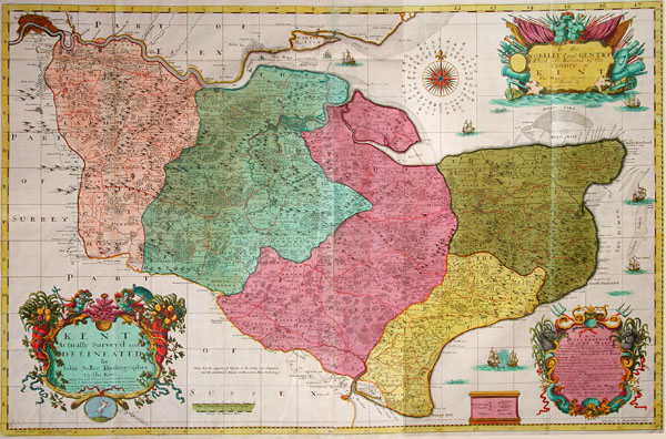
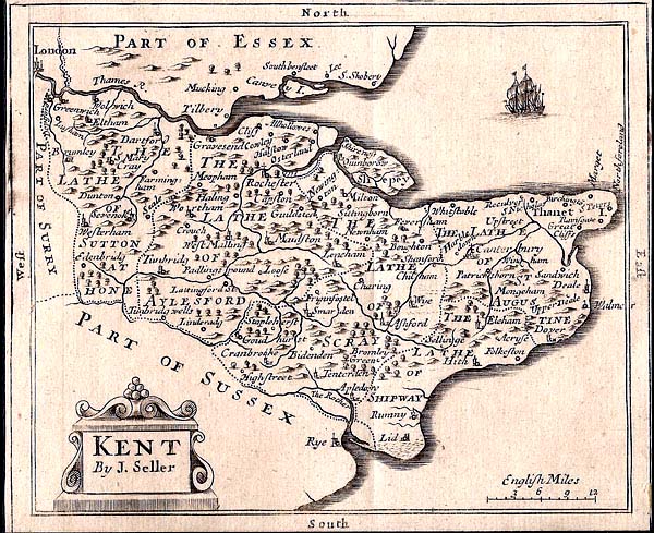
The largest is the Lathe and is best illustrated on the two maps below.
The 5 Lathes are coloured
on the map above
The 5 Lathes are named on
this map
The smaller administrative area is the Hundred and is illustrated in
the map below.
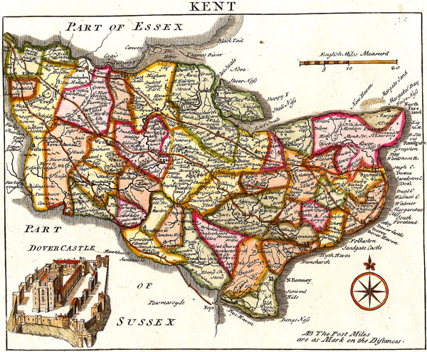
Hundreds do not overlap Lathes, they can be imagined as sub-divisions
of Lathes.
Parishes are further sub-divisions of Hundreds.
Some maps may show a small portion of Kent residing on the northern
shores of the Thames in Essex. This dates back to ancient times
when 400 acres of Essex were granted to Kent for the benefit of running
a ferry at Woolwich. Click for
examples.
Colour printing did not get going until the mid to late 1800s, so all
earlier maps were hand coloured. Some were coloured at the time of
publication, some later. Variations in colouring styles will make the
same basic map look completely different. The newcomer studying antique
maps is sometimes confused when comparing similar maps with changing
decorative colour styles.
Follow this link for an example of map
colouring.
For the novice contemplating old maps one of the first tasks is to
track down one's own hometown or family settlement. These maps do not
show all centres of civilisation. If a village is not shown on a map it
is not an indication that it did not exist at that time, it only
indicates that it does not appear on that map. Many of Kent's
towns and villages date back to Saxon times and earlier. Some,
like Tudeley are probably no larger now than they were 1000 years
ago. Some like Pembury increased in size with the expansion of
coach traffic in the mid 1700s. Some expanded with the coming of
the railways and some, like Paddock Wood, sprang out of nowhere with
the coming of the railways. A few towns, like Pembury moved their
centre of gravity to suit changes in life style. In this case the
village businesses developed on the main Hastings road, a mile from the
old church community to take advantage of the increased road traffic
and mail transportation. To the untrained eye it would appear that
on old maps Pembury is located a mile east of its true position.
In truth the older maps indicate the original heart of the village and
the later maps indicate the migrated settlement that later became the
centre of the village.
Click for full
demonstration of village migration.
To fully
appreciate old maps it is necessary to investigate the history of an
area.
Names on old maps will carry wild variations in spelling. These
variations settled to their current state in the 19th century, not by a
formal standardisation, but by an evolution that gradually ironed out
the differences. Local historians have noted something like 11
variations of 'Pembury' over the centuries. These are largely due to a
lack of importance for a standard spelling - there were no correct
versions and no references. Originally, names were passed verbally and
it was the writer's interpretation of how he heard the name that was
transcribed to the document. Different writers - different spellings.
In later years publishers simply copied what others had previously
printed.
While on the subject of copying it is worthwhile mentioning that
cartographic piracy was rife in olden times. Many claimed '... from new
and accurate surveys', but frequently 'new' maps were cobbled together
from previously published data. The inclusion of turnpikes, halfway
houses, milestones and other features sometimes give an insight into
fresh surveys when comparing a range of similar maps. The coming of the
railways, mail coaches and the penny post drove a demand for up to date
maps from recent surveys.
There are several interesting aspects of antique maps as well as the
county
maps shown above. There are local, regional maps, road maps,
maps of the Hundreds, and folding maps for travelers. Maps of all
vintages were produced for specific purposes. Some for indicating
roads, railways, market towns, geology, battles, land ownership, land
usage, political divisions and many more. Features of little
interest to the mapmaker were not included. If some other features are
included it is for reference purposes only. A map indicating
roads is of no use unless it makes a reference to towns and villages,
but it need not indicate land ownership or parish boundaries. It may
not refer to railways unless the mapmaker considered rail interfaces
with roads worthy of mention. Very few railway maps indicate roads or
agricultural land divisions. Old maps are not like modern Ordnance
Survey maps - they do not show everything.
Antique printed maps are not museum pieces. They are readily available
on the open market and there are many collectors and dealers of these
fascinating items.
Web site designed by Tony
Nicholls www.pastpages.co.uk
|
|