Localities - Henwood Green Road
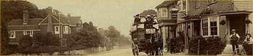
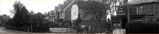
Henwood Green Road – Bo Peep end, junction with Hastings Road
The upper part of Henwood Green Road is better served on the Lower Green page.
All maps have a unique reference number in their bottom-right corner. Please quote this number when commenting.
The maps aim to cover roughly the same area, but they are not of equal scale relative to each other.
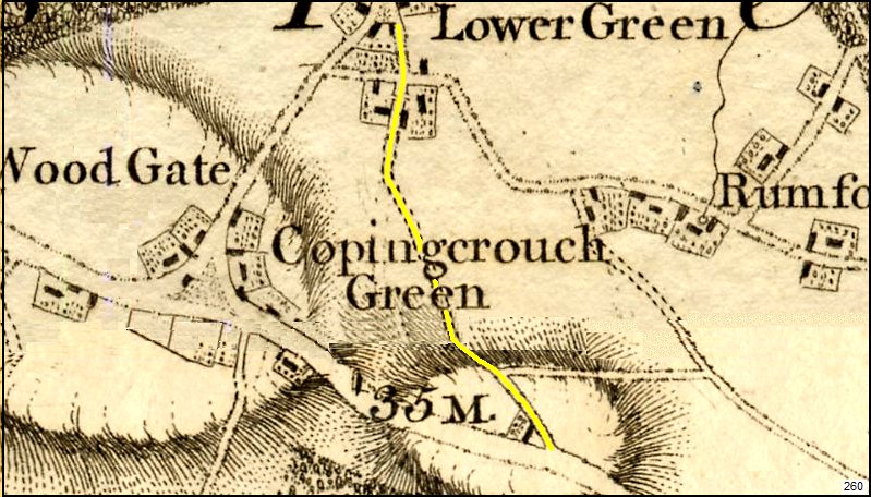
Above: Andrews & Drury map (1796) of Pembury with Henwood Green Road highlighted in yellow.
It was the route from Hastings & Rye to Maidstone and the Lower Green area of Pembury, avoiding the village green.
Note the mapping error in what would later be Woodside Road –
the tracks between Henwood Green Road and Romford Road are clearly incorrect, probably due to poor surveying.
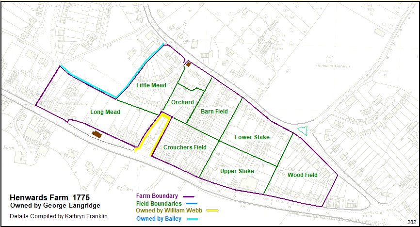
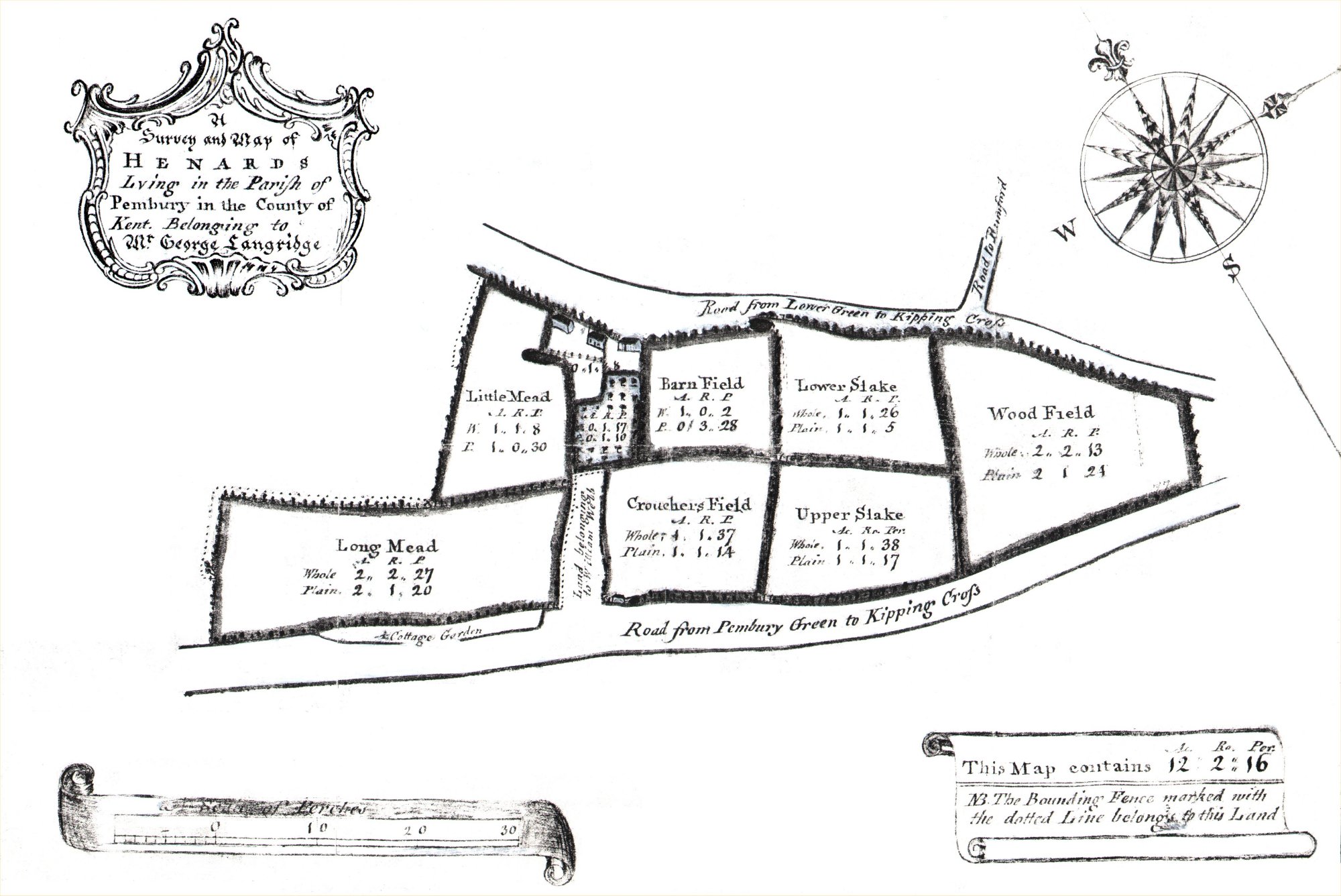
Above: a map created from data
obtained by Kathryn Franklin showing Henward’s Farm in 1775.
Original map below.
It is layered over a modern map to give an indication of location relative to today’s roads and features.
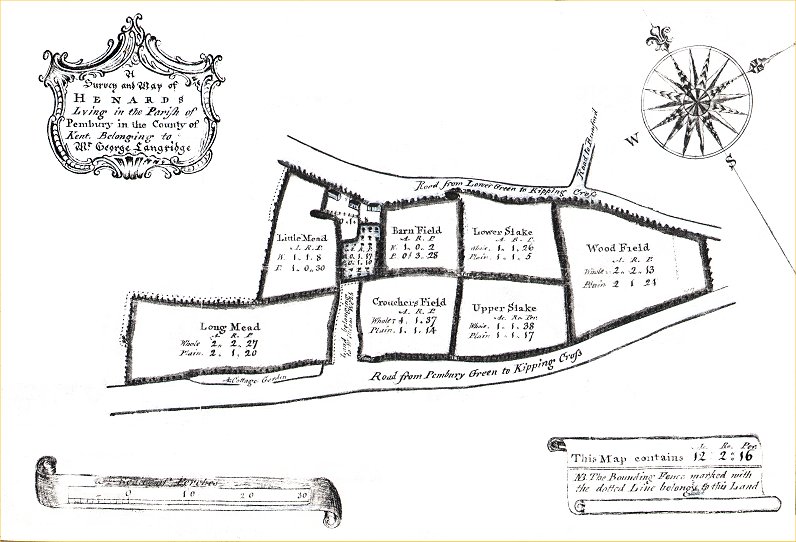
Above: The original 1775 map of Henards Farm. (Larger Image)
Each division is measured in Acres, Roods (4 per acre) and Perches (40 per rood).
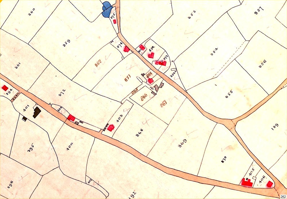
Above: 1840 Tithe map showing Henwood Green Road and Hastings Road junction. Plot usage below.
Buildings marked red were inhabited. Grey, shaded or black – uninhabited : barns, outhouses, etc.
| Plot |
Description |
| 189 |
“Romford Wood” woodland Owner- Camden, Tenant- J & T Stevenson |
| 403 |
Shop & house
(later King William IV pub) Owner &
Tenant- Edward Gower |
| 404 |
House & garden Owner- Thomas Martin, Tenant- Richard Homewood |
| 405 |
House & garden Owner- Edward Gower, Tenants- Chapman, Tester, Boorman, Faggot, Smith. |
| 406 |
House & garden Owner- Stephen Hickmott, Tenant- Stephen Hickmott |
| 852 |
“Bayley Farm House” (Baileys Farmhouse) Owner- Thomas Smith, Tenant- William Fry |
| 853 |
arable Owner- Thomas Smith, Tenant- Edward Gower |
| 854 |
hops Owner- Thomas Smith, Tenant- Edward Gower |
| 855 |
arable Owner- Thomas Smith, Tenant- Edward Gower |
| 859 |
meadow Owner- Thomas Smith, Tenant- Edward Gower |
| 861 |
hops Owner- Thomas Smith, Tenant- Edward Gower |
| 862 |
“Barn Field”
meadow Owner- Thomas
Smith, Tenant- Edward Gower |
| 863 |
Porters lodge & garden Owner- Daniel Fowler, Tenant- John Slaughter |
| 864 |
“Pitts Farm” Houses &
Buildings Owner-
Elizabeth Boorman, Tenant- Elizabeth Boorman |
| 865 |
“Droveway” Owner- Elizabeth Boorman, Tenant- Elizabeth Boorman. see various notes scattered about this page.
Droveway was an ancient term for a track specifically for driving cattle, sheep, pigs, etc. |
| 866 |
orchard Owner- Elizabeth Boorman, Tenant- Elizabeth Boorman |
| 867 |
orchard Owner- Elizabeth Boorman, Tenant- unlet.
Building close to Henwood Gn Rd with circular feature identified as an oast house. |
| 868 |
“Square Field” meadow
Owner- Elizabeth
Boorman, Tenant- unlet |
| 869 |
“Slate Field”
meadow Owner- Elizabeth
Boorman, Tenant- unlet
The boundary between 869 and 867+868 would later become Canterbury Road.
The boundary between 869 and 870 might be the later location of Stanham Road, but –
the division of these fields is not shown on later maps between 1868 – 1913.
Map 265 does indicate a row of trees on this line. |
| 870 |
“Upper Hop Field”
hops Owner- Elizabeth
Boorman, Tenant- unlet |
| 871 |
“Faggot Field” arable Owner- Elizabeth Boorman, Tenant- unlet |
| 872 |
“Long Hop Field” hops Owner- Elizabeth Boorman, Tenant- unlet |
| 873 |
“4 x House & Garden” Bayleys Farm
cottages Owner- Samuel Dickenson, Tenants- Sam Dickenson, John Ellis,
John Birch, Richard Kemp. |
| 874 |
barn, yard, & buildings Owner- Thomas Smith, Tenant- Edward Gower |
| 875 |
Parish of Pembury cottage & garden |
Above: plot descriptions from Tithe Schedule.
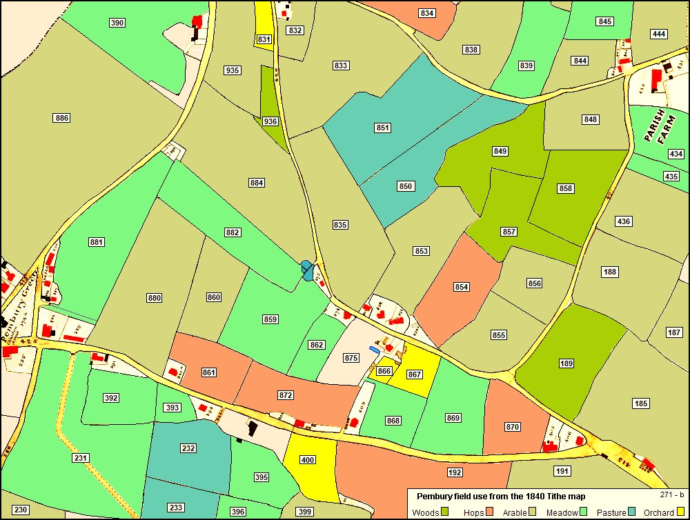
Above: a doctored rendition of the 1840 Tithe Map showing the field use at the time.
The use of the fields is taken from the 1840 Tithe Schedule.
Note that the use may change from year to year, decade to decade.
Smaller plots close to houses are rated as gardens or grounds.
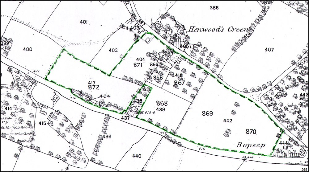
Above: a OS map of 1865 that has been amended to include a specific group of field & plots (highlighted here in green).
This must have been done to indicate a sale, a purchase or just ownership of land.
The enclosed parcel of land shows the modern field numbers (4xx) and the plot numbers (8xx) from the Tithe map of 1840.
Fields outside this enclosure do not have the 1840 Tithe plot numbers.
Most of this enclosed land appears to be owned by Elizabeth Boorman in 1840.
The footpath between fields 400 and 417 would eventually become Belfield Road.
The enclosure does not include plot 438 – the King William IV public house.
Plots 871 (404), 864 and 866 can be identified as ‘Pitt’s Farm’ a few
years later. Later still to become Sturgeon’s haulage depot.
Fields 867 (418) and 868 (439) would later be bisected by Canterbury Road.
The division between fields 868 (439) + 867 (418) and 869 (442) is shown
as a footpath between Hastings Road and Henwood Green Road.
This footpath exists today (2021) on modern maps mid way between Canterbury Road and Stanam Road.
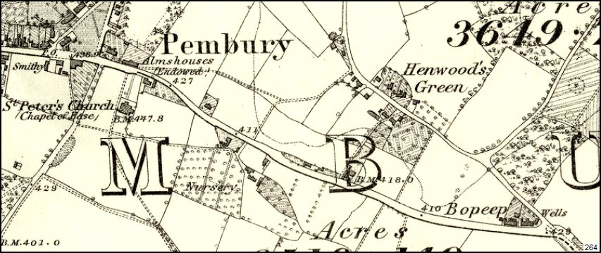
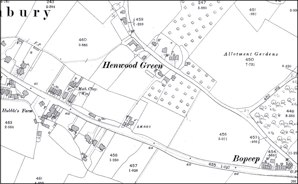
Above: OS map 1864 showing Henwood Green Road and Hastings Road junction.
Subsequent maps dated 1873, 1896 show very little change in Henwood Green Road or this end of Hastings Road.
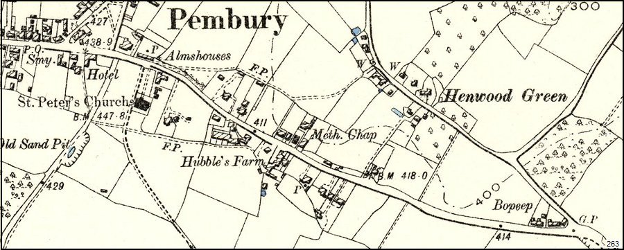
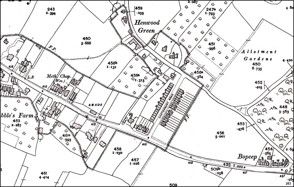
Above: OS map (1888 – 1913) showing Henwood Green Road and Hastings Road junction.
Two wells (W) noted in Henwood Green Road, several ponds, and Guide Post at Bo Peep corner.
Above: OS map of 1897 with greater detail and precision than earlier maps.
More wells (W) are marked and now pumps (P) for the easier extraction of ground water.
This appears to be the last map to show the continuous path – the
‘droveway’ from Hastings Road (King William iV pub) to Henwood Green
Road.
Above: 1909 map showing the devlopment of Canterbury Road and the division of fields.
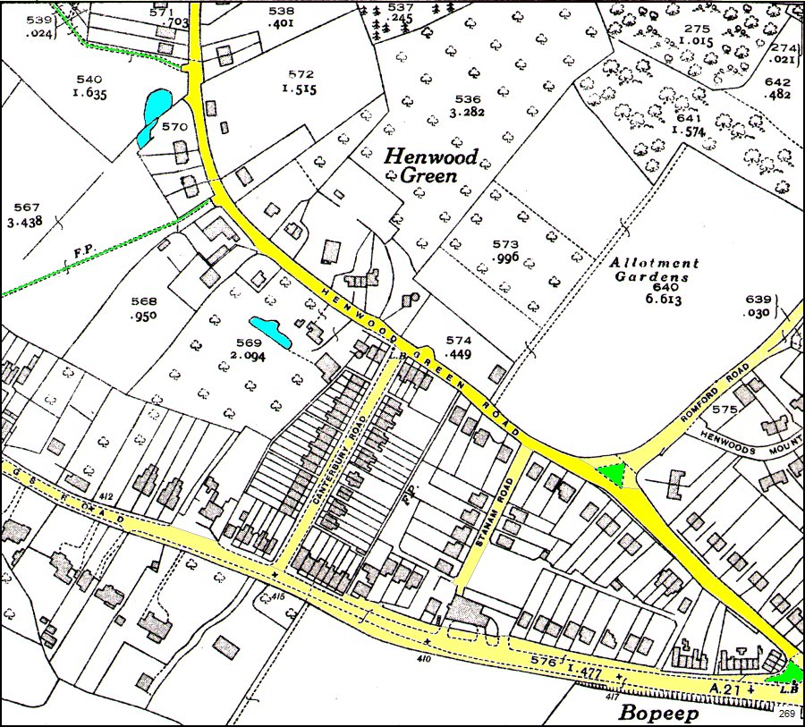
Above: OS map of c1938 of the Bo Peep, Henwood Green Road area. Colour enhanced key features.
Various versions of this map appear below to highlight certain aspects of the history and development of Henwood Green Road.
Note the incorrect naming of Woodside Road as Romford Road.
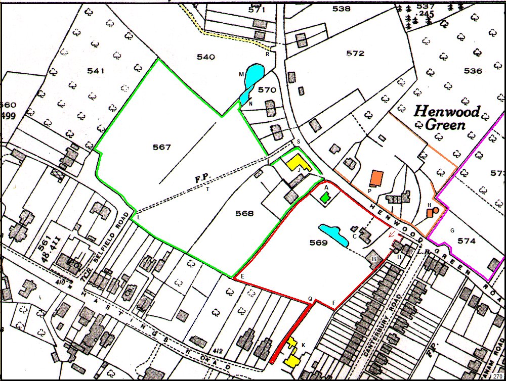
Above: a more detailed section of map 269 with many features described by Barry Sturgeon below –
| Red |
Red boundary indicates Pitt’s Farm – Sturgeon Haulage depot.
Access via Henwood Gren Road and Hastings Road (King William IV pub) |
| Magenta |
Magenta boundary indicates Sturgeon Coal & Coke & depot |
| Green |
Green boundary indicates Smitherson’s Farm.
Barry Sturgeon remembers a travelling circus at plot 567 on several occasions (c1946-47). |
| A |
Pitt’s Farm Cottage. The home of Alice Legg (dressmaker) for many years. |
| B |
Garage & Workshop |
| C |
Pitt’s Farm House |
| D |
House in Canterbury Rd – not a part of Pitt’s Farm. Circular feature identified as an oast house. |
| E |
Corner marker of plot 569 |
| F |
Corner marker of plot 569 |
| G |
G.S. Sturgeon’s depot for coal & coke |
| H |
The Oast House – shown here for landmark purposes. |
| J |
A building identified as a large pig stye by Barry Sturgeon – c19xx ??? |
| K |
King William IV pub – side track used as access to Pitt’s Farm depot. |
| L |
Footpath at Belfield Road. |
| M |
Pond in plot 540. This, in modern times, is the top junction of Henwood Crescent. |
| N |
Pond in plot 570. Same pond, extending across second field boundary. |
| P |
Bailey’s Farmhouse -opposite what will become Henwood Crescent.
Footprint of original farm yet to be established.
|
| Q |
c1938 – the track from the King William pub to Pitt’s Farm.
This track appears on the 1840 Tithe map as plot 865 – ‘Droveway’.
Droves were designated routes for driving cattle and wildstock. The
track was used in the 1940s by Sturgeons as their access to Pitt’s Farm
from Hastings Road and it is still preserved in 2021 as a narrow path –
c1970 – 2021 a very narrow path by the side of 9 Henwood Crescent
leading to Hastings Road, by the side of the King William IV pub. This
is not a designated footpath, but seems to maintain an old footway
between Hastings Rd. and Henwood Green Rd. See maps 281 and 295 lower
down this page. |
| R |
Start of footpath. This is still in use in 2021 at the top of Henwood Crescent to Belfield Rd. |
| S |
Footpath at Henwood Green Road. Still in use in 2021. |
| T |
Approximate location of later intersection of footpath with Henwood Crescent. |
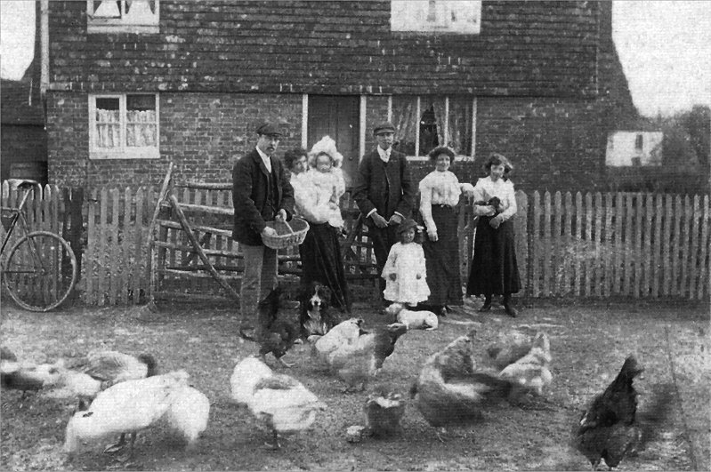
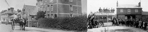
Above: Photo of the Russell family at Pitt’s Farm smallholding c1910
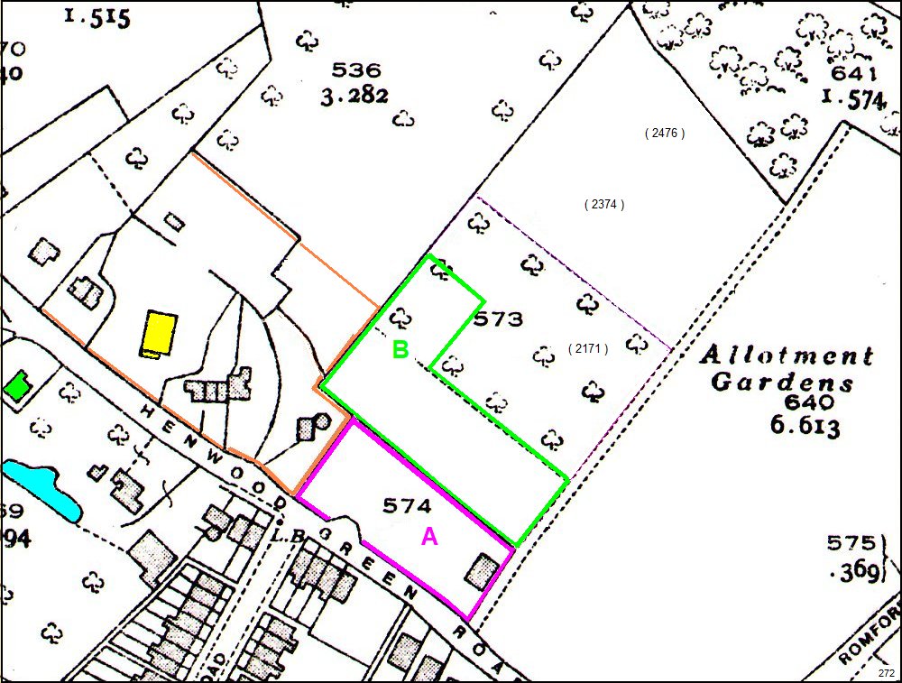
Above: detail of the c1938 map showing the footprint of the G.S. Sturgeon depot.
The original Sturgeon purchase was area A, followed by a later purchase of area B
To the left Bailey’s Farmhouse is coloured yellow. The footprint of
the farm has yet to be determined. This boundary is just a guess.
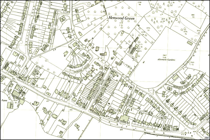
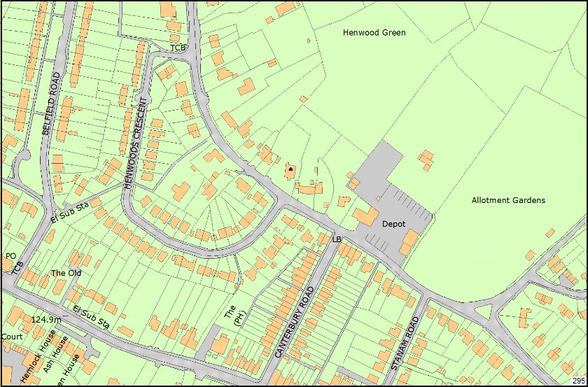
Above:
OS map of c1970 of the Henwood Green Road area. Below the
same map with colour enhancement of key features.
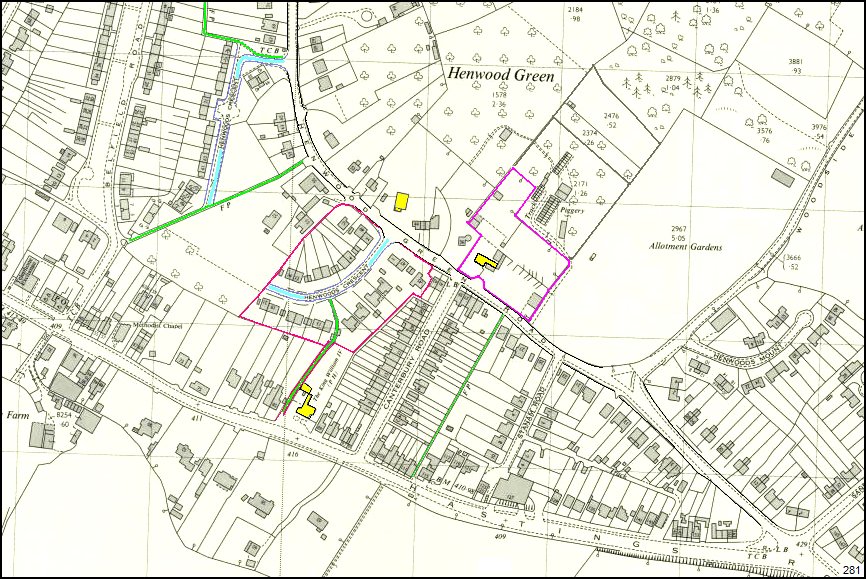
Above : map of c1970 showing later developments in Henwood Green Road.
Pitt’s Farm has now gone to housing development. Pitt’s Farm footprint still visible.
Sturgeon’s coal depot is shown and a piggery is in operation in the attached plot.
The house known as ‘Montrose’ on the Sturgeon site is shown in yellow.
Both ponds, from earlier maps, have now gone.
Henwood Crescent is seen as two ends, waiting for the central section, at Smitherson’s Farm, to become available.
The old droveway shown in 1840, and later footpaths linking Hastings Rd
& Henwood Green Rd are still shown in the maps above & below.
The footpath between Canterbury Rd and Stanam Rd, that was a field boundary, has also been highlighted in green.
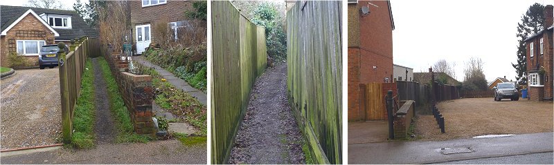
Above:
a 2021 photos of the ‘droveway’ path. Left from Henwood
Crescent. Right from Hastings Road (King William IV pub).
Above: the landscape in 2021
Note the kink in the central footpath to accommodate new housing.
The ‘droveway’ path between Henwood Crescent and the side of the King William IV pub is still recognisable on these modern maps.
Maps compiled in 2021 by Tony
Nicholls. Local historic content and
advice courtesy of Barry Sturgeon.
IMPORTANT !!! This needs your help. All contributions will be credited.
If you have any further information or corrections please contact me –
Tony Nicholls email: history@pembury.org