Past Pages
Antique Maps, Prints and Ephemera
Antique Maps - UK Rivers & Canals
Some maps are printed with another map on the reverse. Only one is illustrated on some descriptions.
Not all maps are oriented with North facing the top of the page.
River & Canal Maps |
|
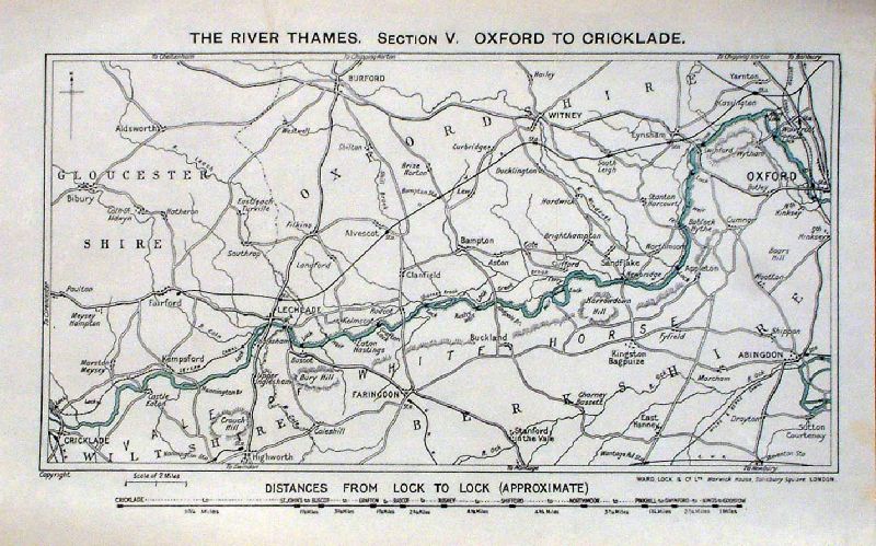 |
The River Thames. Section V. Oxford
to Cricklade Ward Lock c1900 The Thames from Cricklade to Oxford with distance chart of the 12 locks at Cricklade, St Johns, Buscot, Grafton, Radcot, Rushey, Shifford, Northmoor, Pinkhill, Swinford, Kings, Godstow size : 260 x 160 mm 2 folds. Ref JLM031 £18.00 (+P&P) click image for enlargement |
 |
Map of the
Canals
Stockdale 1796 The canals around London, along with major rivers around London size : 280 x 220 mm Detail Ref NLM004 £32.00 (+P&P) click image for enlargement |
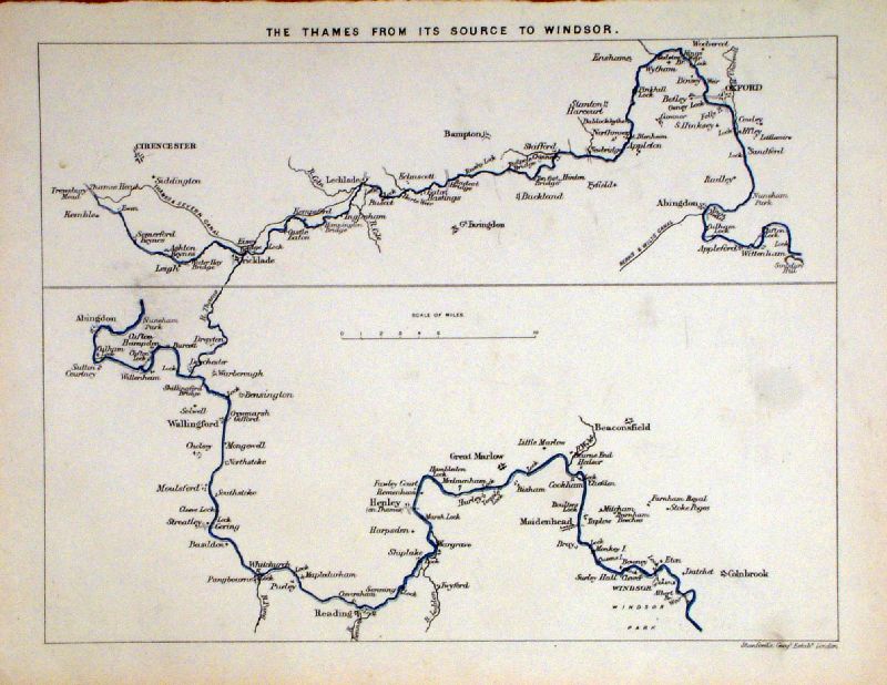 |
The Thames from its
Source to Windsor Stanford c1880 size : 280 x 220 mm 1 fold Detail Ref KFM019 £25.00 (+P&P) click image for enlargement |
 |
The River Dee from
its source to the Ocean
anon c1840 Features Aberdeen, Charlston, Ballater, Invergeldie, Castletown Vignette of Old Balmoral size : 420 x 140 mm 3 folds, damage to far right margin - 80mm missing. Ref EDM008 £25.00 (+P&P) Detail1 Detail2 click image for enlargement |
 |
The Thames through
Windsor. Windsor Park and Vicinage Wyld / Blackwood 1842 size : 130 x 230 mm Detail featuring Windsor, Staines, Egham, Thorpe, Dorney, Slough, Iver .... Ref LCM007 £28.00 (+P&P) click image for enlargement |
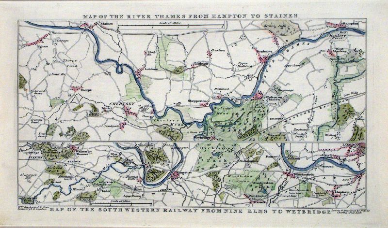 |
Map of the River
Thames from Hampton to Staines (top) Map of the South Western Railway from Nine Elms to Weybridge Wyld / Blackwood 1842 size : 230 x 130 mm Detail Detail featuring Walton on Thames, Shepperton, Chertsey, Kingston, Weybridge, Esher, Egham ..... Ref LCM008 £28.00 (+P&P) click image for enlargement |
|
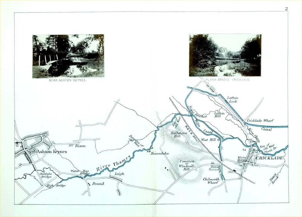
The Thames - Cricklade to Ashton Keynes Henry Taunt 1897 - from Taunt's Illustrated Map of the Thames Inset are 2 miniature photographs of local views size : 220 x 160 mm - centre fold - some discolouration from photograph offest or adhesive. Ref PLM010 £18.00 (+P&P) click image for enlargement |
|
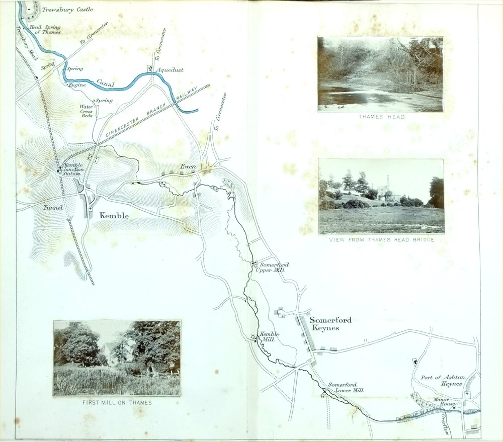
The Thames - Kemble, Somerford Keynes Henry Taunt 1897 - from Taunt's Illustrated Map of the Thames Inset are 3 miniature photographs of local views size : 220 x 160 mm - cropped top & bottom margins. centre fold - some discolouration from photograph offest or adhesive. Ref PLM011 £18.00 (+P&P) click image for enlargement |
|
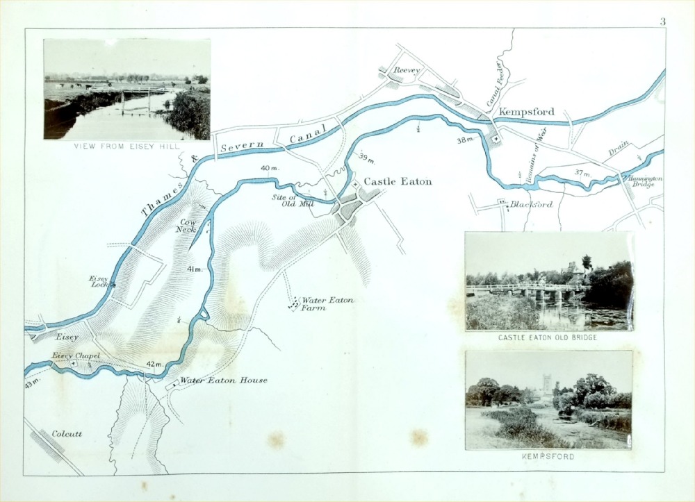
The Thames - Kempsford, Castle Eaton, Thames &
Severn Canal Henry Taunt 1897 - from Taunt's Illustrated Map of the Thames Inset are 3 miniature photographs of local views size : 220 x 160 mm - centre fold - some discolouration from photograph offest or adhesive. Ref PLM012 £18.00 (+P&P) click image for enlargement |
|
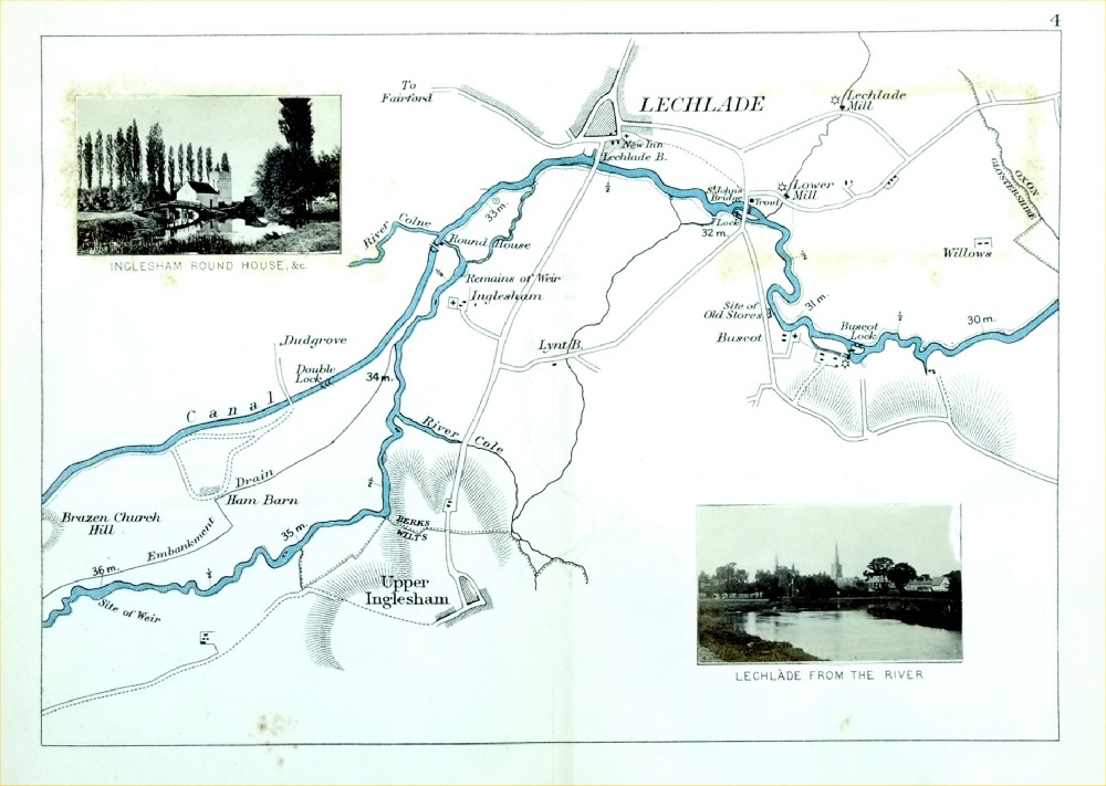
The Thames - Letchlade, Upper Inglesham, Thames
& Severn Canal Henry Taunt 1897 - from Taunt's Illustrated Map of the Thames Inset are 2 miniature photographs of local views size : 220 x 160 mm - centre fold - some discolouration from photograph offest or adhesive. Ref PLM013 £18.00 (+P&P) click image for enlargement |

|
The Thames - Kelmscott, Radcot Bridge, Thrup Henry Taunt 1897 - from Taunt's Illustrated Map of the Thames Inset are 3 miniature photographs of local views size : 220 x 160 mm - centre fold - some discolouration from photograph offest or adhesive. Ref PLM015 £18.00 (+P&P) click image for enlargement |
|
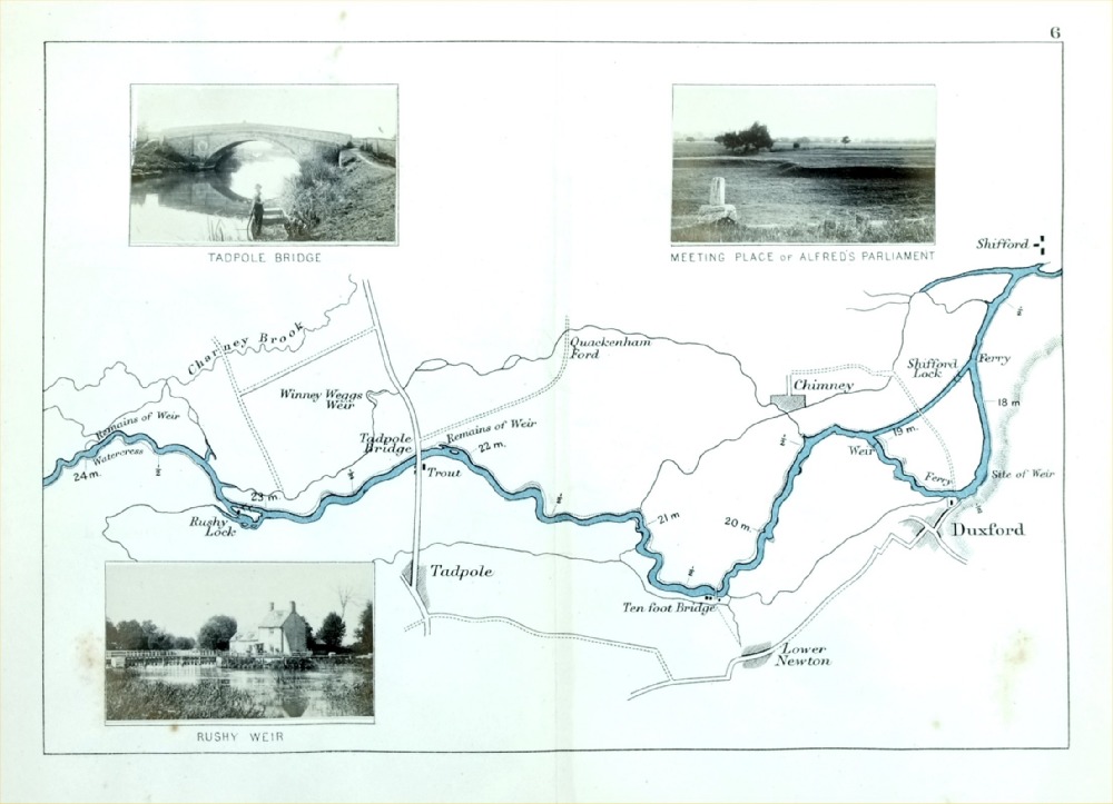
The Thames - Duxford, Tadpole, Shifford Henry Taunt 1897 - from Taunt's Illustrated Map of the Thames Inset are 3 miniature photographs of local views size : 220 x 160 mm - centre fold - some discolouration from photograph offest or adhesive. Ref PLM016 £18.00 (+P&P) click image for enlargement |
|
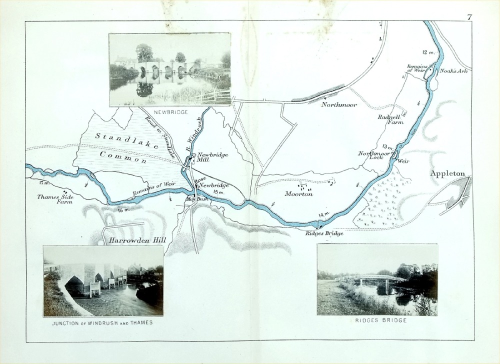
The Thames - Newbridge, Appleton, Northmoor,
Sandlake Common Henry Taunt 1897 - from Taunt's Illustrated Map of the Thames Inset are 3 miniature photographs of local views size : 220 x 160 mm - centre fold - some discolouration from photograph offest or adhesive. Ref PLM017 £18.00 (+P&P) click image for enlargement |

|
The Thames - Stanton Harcourt, Eynsham, Pinkhill Henry Taunt 1897 - from Taunt's Illustrated Map of the Thames Inset are 3 miniature photographs of local views size : 220 x 160 mm - centre fold - some discolouration from photograph offest or adhesive. Ref PLM018 £18.00 (+P&P) click image for enlargement |
|
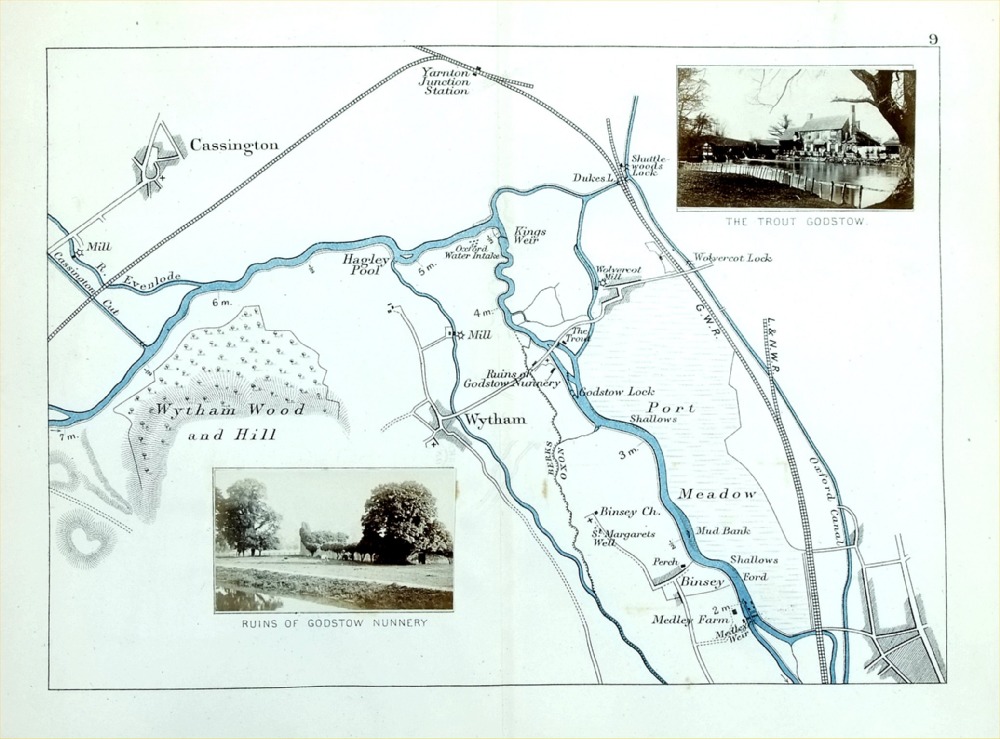
The Thames - Wytham, Cassington, Binsey, Oxford
Canal Henry Taunt 1897 - from Taunt's Illustrated Map of the Thames Inset are 2 miniature photographs of local views size : 220 x 160 mm - centre fold - some discolouration from photograph offest or adhesive. Ref PLM019 £18.00 (+P&P) click image for enlargement |
|
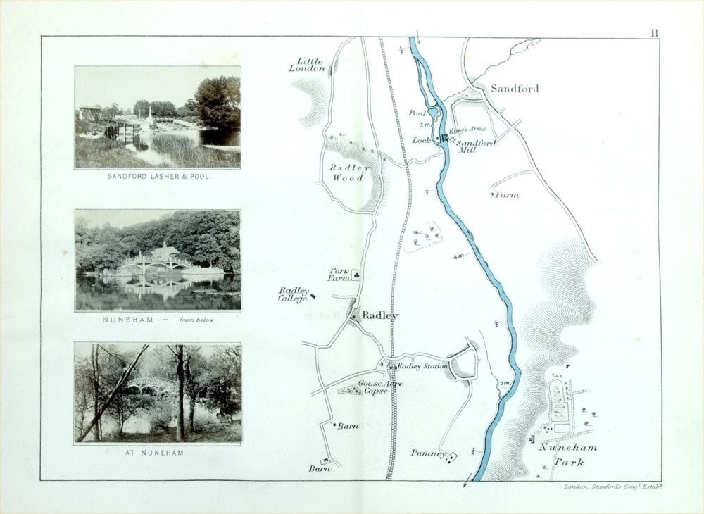
The Thames -Sandford, Radley, Nuneham Park Henry Taunt 1897 - from Taunt's Illustrated Map of the Thames Inset are 3 miniature photographs of local views size : 220 x 160 mm - centre fold - some discolouration from photograph offest or adhesive. Ref PLM021 £18.00 (+P&P) click image for enlargement |
|
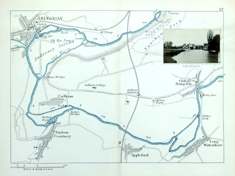
The Thames - Abingdon, Culham, Clifton Hampden,
Long Wittenham, Appleford, Sutton Courtney Henry Taunt 1897 - from Taunt's Illustrated Map of the Thames Inset are 1 miniature photograph of local view size : 220 x 160 mm - centre fold - some discolouration from photograph offest or adhesive. Ref PLM022 £18.00 (+P&P) click image for enlargement |
|
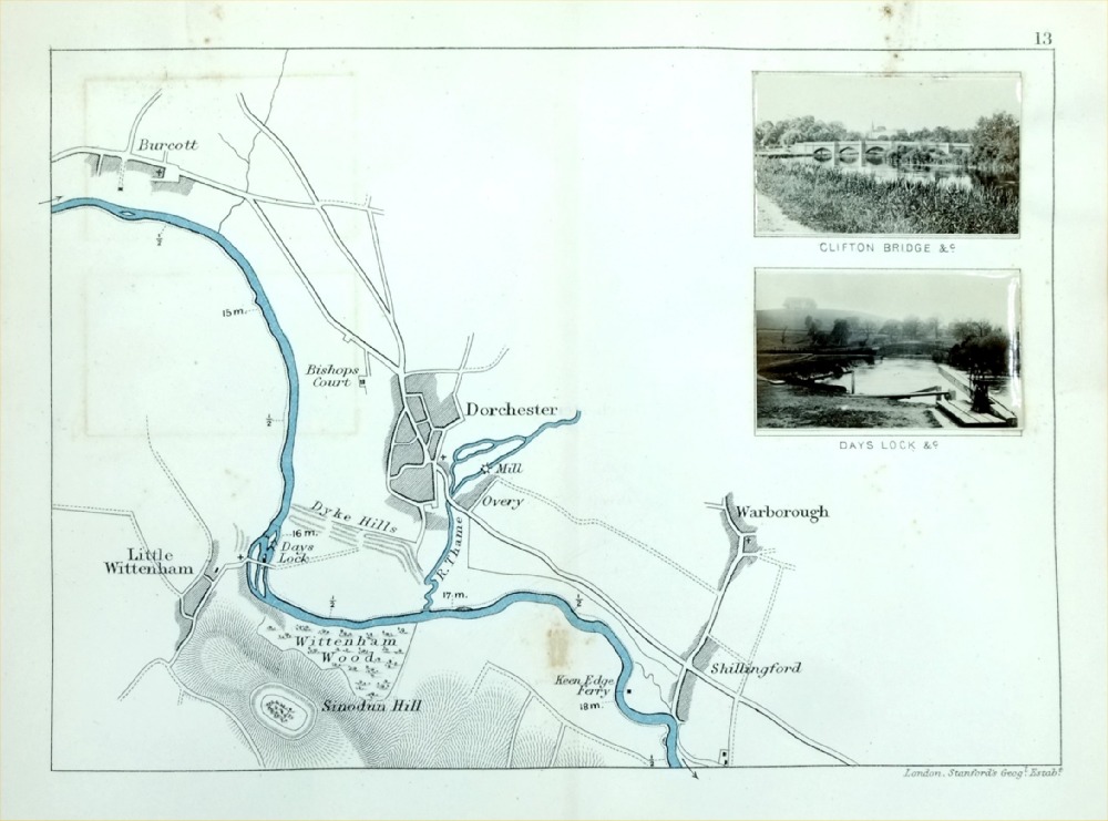
The Thames - Dorchester, Little Wittenham,
Warborough, Shillingford, Burcott Henry Taunt 1897 - from Taunt's Illustrated Map of the Thames Inset are 2 miniature photographs of local views size : 220 x 160 mm - centre fold - some discolouration from photograph offest or adhesive. Ref PLM023 £18.00 (+P&P) click image for enlargement |

|
The Thames - Wallingford, Benson, Shillingford
Bridge, Nuneham Murren Henry Taunt 1897 - from Taunt's Illustrated Map of the Thames Inset are 3 miniature photographs of local views size : 220 x 160 mm - centre fold - some discolouration from photograph offest or adhesive. Ref PLM024 £18.00 (+P&P) click image for enlargement |
|
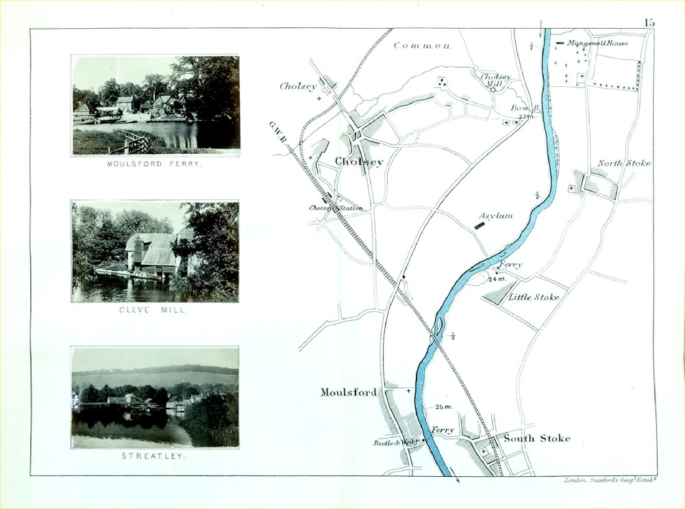
The Thames - Cholsey, Moulsford, South Stoke Henry Taunt 1897 - from Taunt's Illustrated Map of the Thames Inset are 3 miniature photographs of local views size : 220 x 160 mm - centre fold - some discolouration from photograph offest or adhesive. Ref PLM025 £18.00 (+P&P) click image for enlargement |
|
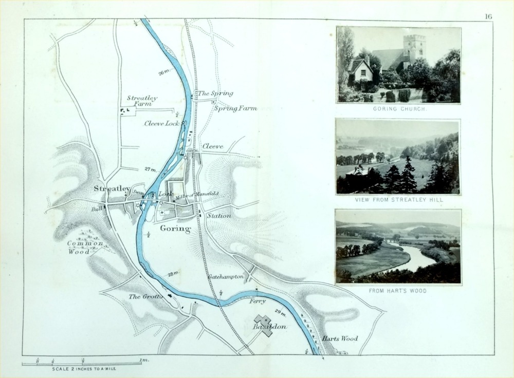
The Thames - Goring, Streatley, Hart's Wood Henry Taunt 1897 - from Taunt's Illustrated Map of the Thames Inset are 3 miniature photographs of local views size : 220 x 160 mm - centre fold - some discolouration from photograph offest or adhesive. Ref PLM026 £18.00 (+P&P) click image for enlargement |
|
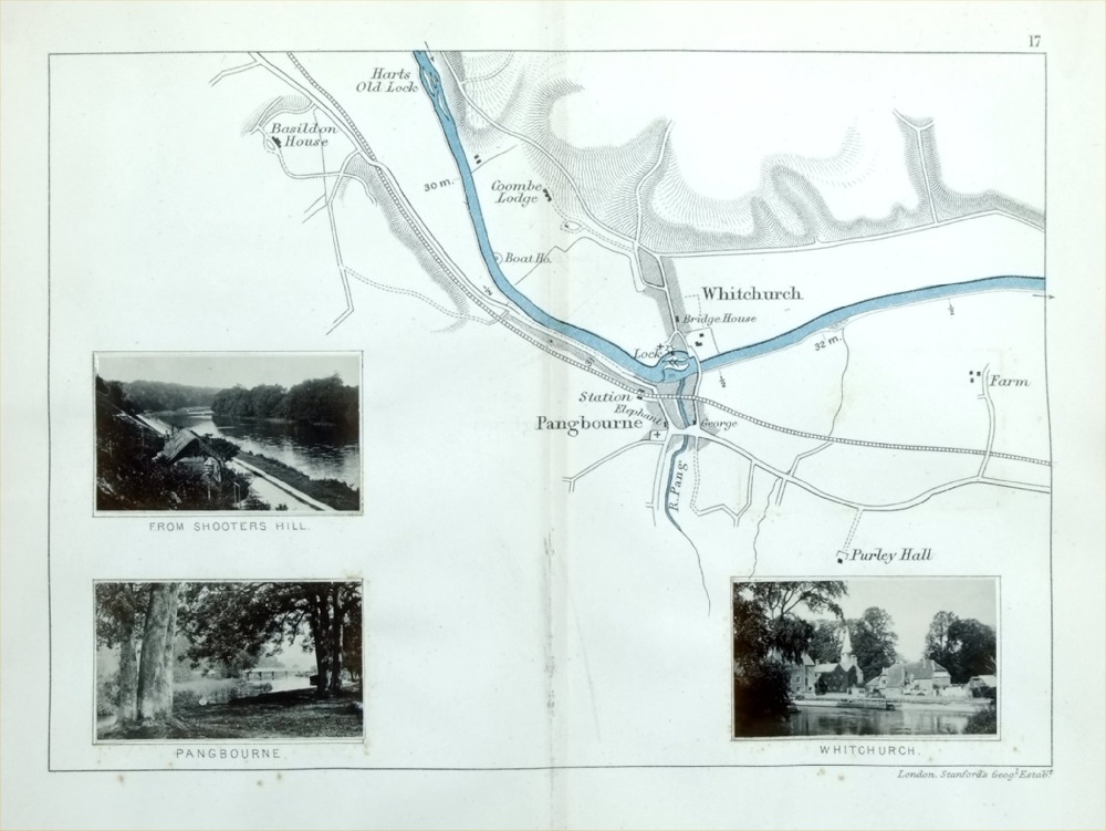
The Thames - Pangbourne, Whitchurch Henry Taunt 1897 - from Taunt's Illustrated Map of the Thames Inset are 3 miniature photographs of local views size : 220 x 160 mm - centre fold - some discolouration from photograph offest or adhesive. Ref PLM027 £18.00 (+P&P) click image for enlargement |
|
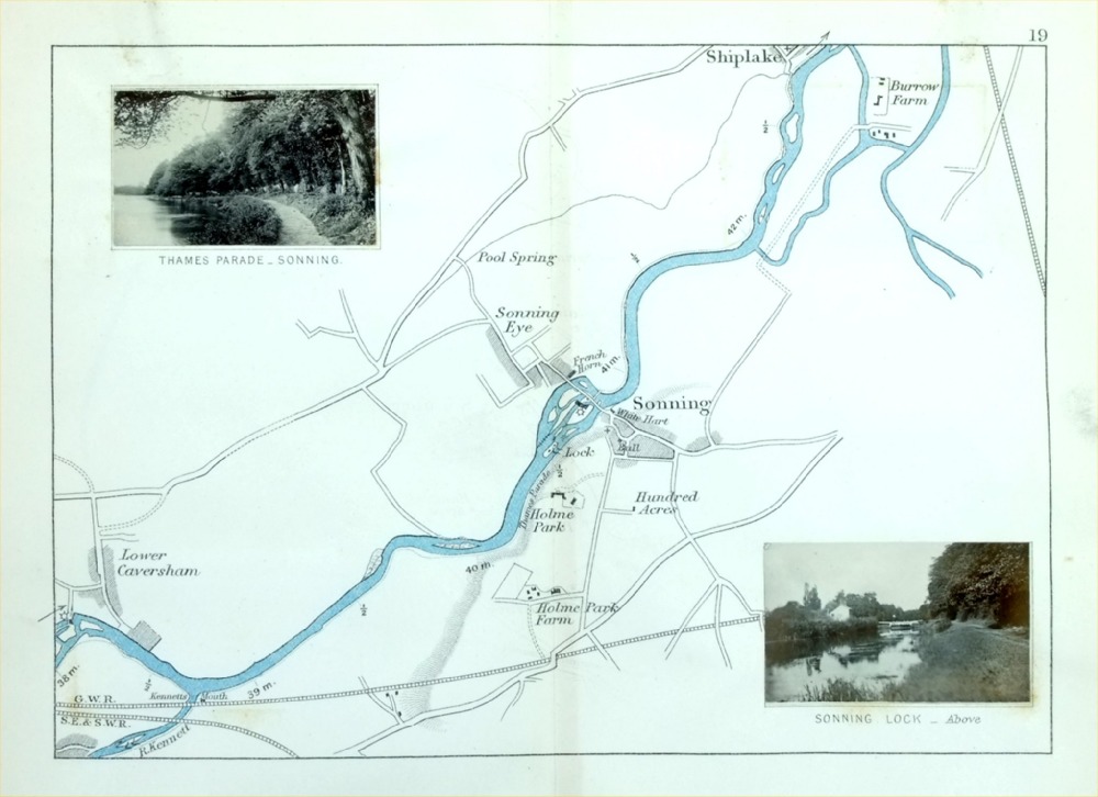
The Thames - Shiplake, Sonning, Lower Caversham Henry Taunt 1897 - from Taunt's Illustrated Map of the Thames Inset are 2 miniature photographs of local views size : 220 x 160 mm - centre fold - some discolouration from photograph offest or adhesive. Ref PLM029 £18.00 (+P&P) click image for enlargement |
|
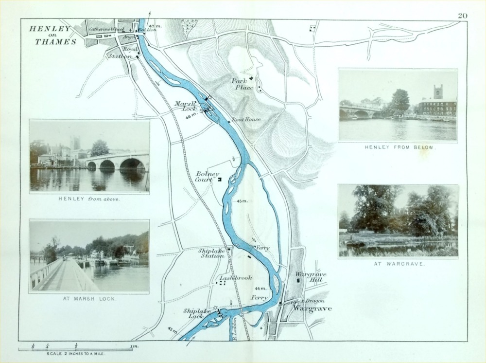
The Thames - Henley on Thames, Wargrave Henry Taunt 1897 - from Taunt's Illustrated Map of the Thames Inset are 4 miniature photographs of local views size : 220 x 160 mm - centre fold - some discolouration from photograph offest or adhesive. Ref PLM030 £18.00 (+P&P) click image for enlargement |
|
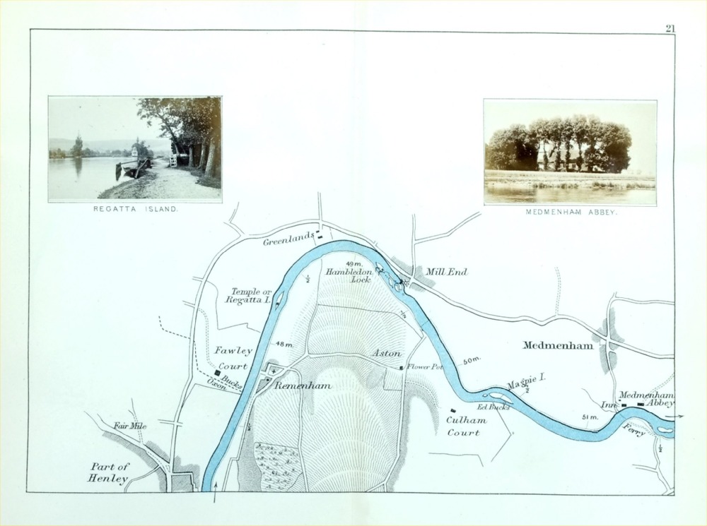
The Thames - Medmenham, Mill End, Regatta Island,
Part of Henley Henry Taunt 1897 - from Taunt's Illustrated Map of the Thames Inset are 2 miniature photographs of local views size : 220 x 160 mm - centre fold - some discolouration from photograph offest or adhesive. Ref PLM031 £18.00 (+P&P) click image for enlargement |

|
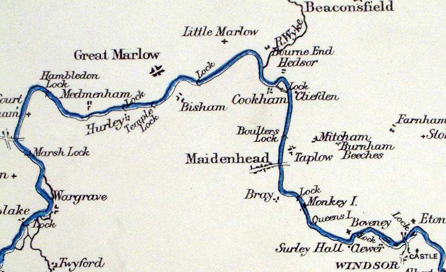
The Thames - Great Marlow, Hurley, Bisham, Cookham
Dean Henry Taunt 1897 - from Taunt's Illustrated Map of the Thames Inset are 2 miniature photographs of local views size : 220 x 160 mm - centre fold - some discolouration from photograph offest or adhesive. Ref PLM032 £18.00 (+P&P) click image for enlargement |
|
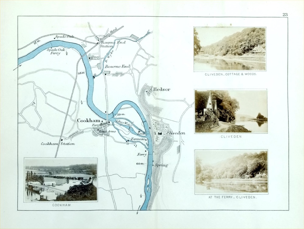
The Thames - Cookham, Hedsor, Bourne End, Cliveden Henry Taunt 1897 - from Taunt's Illustrated Map of the Thames Inset are 4 miniature photographs of local views size : 220 x 160 mm - centre fold - some discolouration from photograph offest or adhesive. Ref PLM033 £18.00 (+P&P) click image for enlargement |

|
The Thames - Bray, Taplow, Maidenhead Henry Taunt 1897 - from Taunt's Illustrated Map of the Thames Inset are 5 miniature photographs of local views size : 220 x 160 mm - centre fold - some discolouration from photograph offest or adhesive. Ref PLM034 £18.00 (+P&P) click image for enlargement |
|
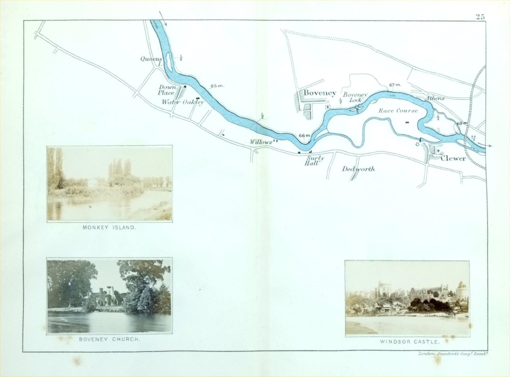
The Thames - Clewer, Boveney Henry Taunt 1897 - from Taunt's Illustrated Map of the Thames Inset are 3 miniature photographs of local views size : 220 x 160 mm - centre fold - some discolouration from photograph offest or adhesive. Ref PLM035 £18.00 (+P&P) click image for enlargement |

|
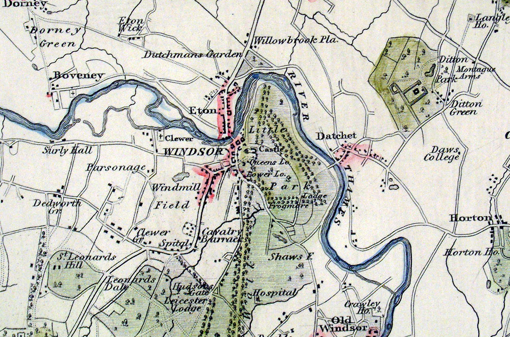
The Thames - Eton, Windsor, Datchet Henry Taunt 1897 - from Taunt's Illustrated Map of the Thames Inset are 3 miniature photographs of local views size : 220 x 160 mm - centre fold - some discolouration from photograph offest or adhesive. Ref PLM036 £18.00 (+P&P) click image for enlargement |
|
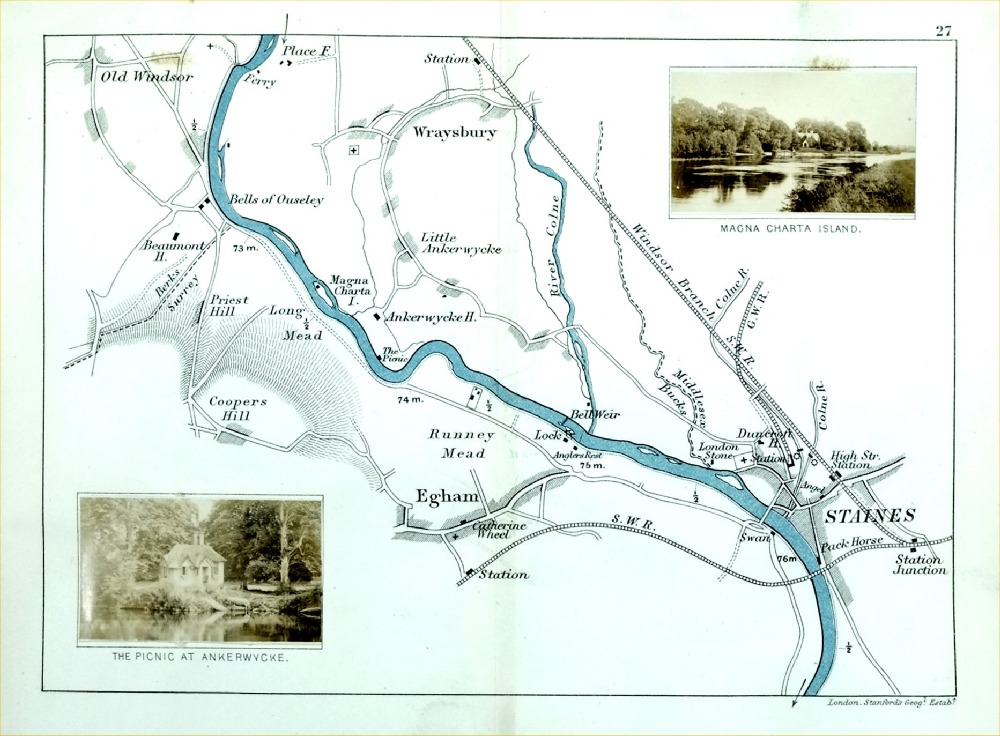
The Thames - Staines, Egham, Wraysbury, Magna
Charta Island Henry Taunt 1897 - from Taunt's Illustrated Map of the Thames Inset are 2 miniature photographs of local views size : 220 x 160 mm - centre fold - some discolouration from photograph offest or adhesive. Ref PLM037 £18.00 (+P&P) click image for enlargement |
|
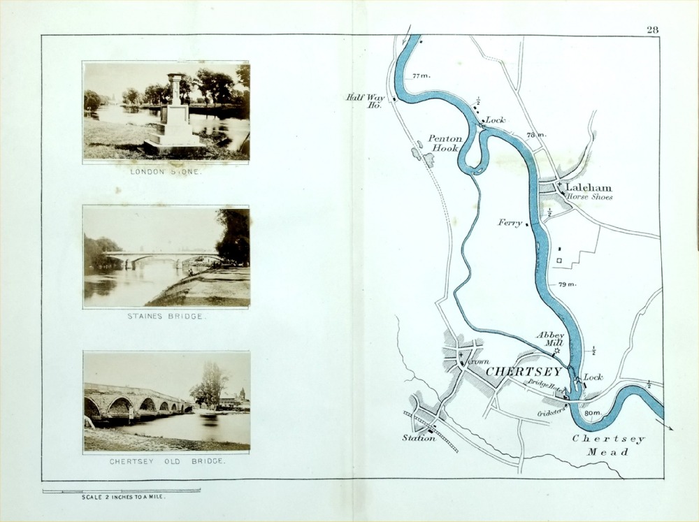
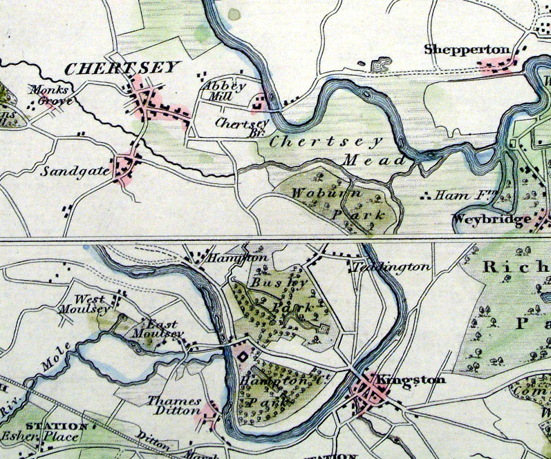
The Thames - Chertsey, Laleham Henry Taunt 1897 - from Taunt's Illustrated Map of the Thames Inset are 2 miniature photographs of local views size : 220 x 160 mm - centre fold - some discolouration from photograph offest or adhesive. Ref PLM038 £18.00 (+P&P) click image for enlargement |
|
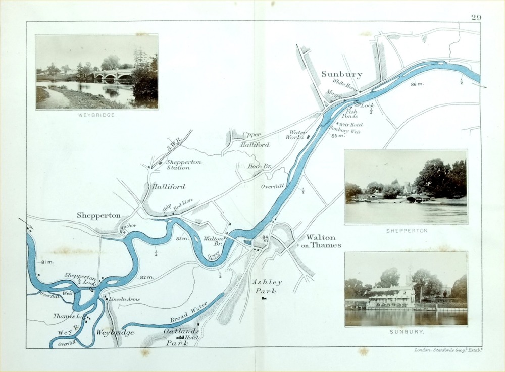
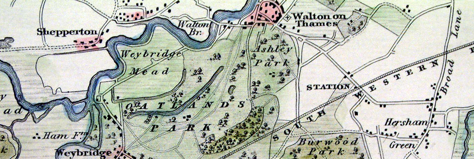
The Thames - Sunbury, Walton on Thames, Weybridge,
Shepperton Henry Taunt 1897 - from Taunt's Illustrated Map of the Thames Inset are 3 miniature photographs of local views size : 220 x 160 mm - centre fold - some discolouration from photograph offest or adhesive. Ref PLM039 £18.00 (+P&P) click image for enlargement |
|
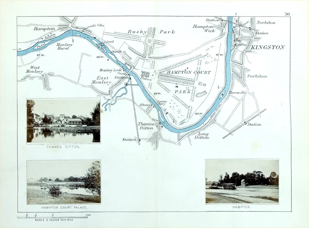
The Thames - Kingston, Hampton Court, Hampton,
East Moulesy Henry Taunt 1897 - from Taunt's Illustrated Map of the Thames Inset are 3 miniature photographs of local views size : 220 x 160 mm - centre fold - some discolouration from photograph offest or adhesive. Ref PLM040 £18.00 (+P&P) click image for enlargement |
|
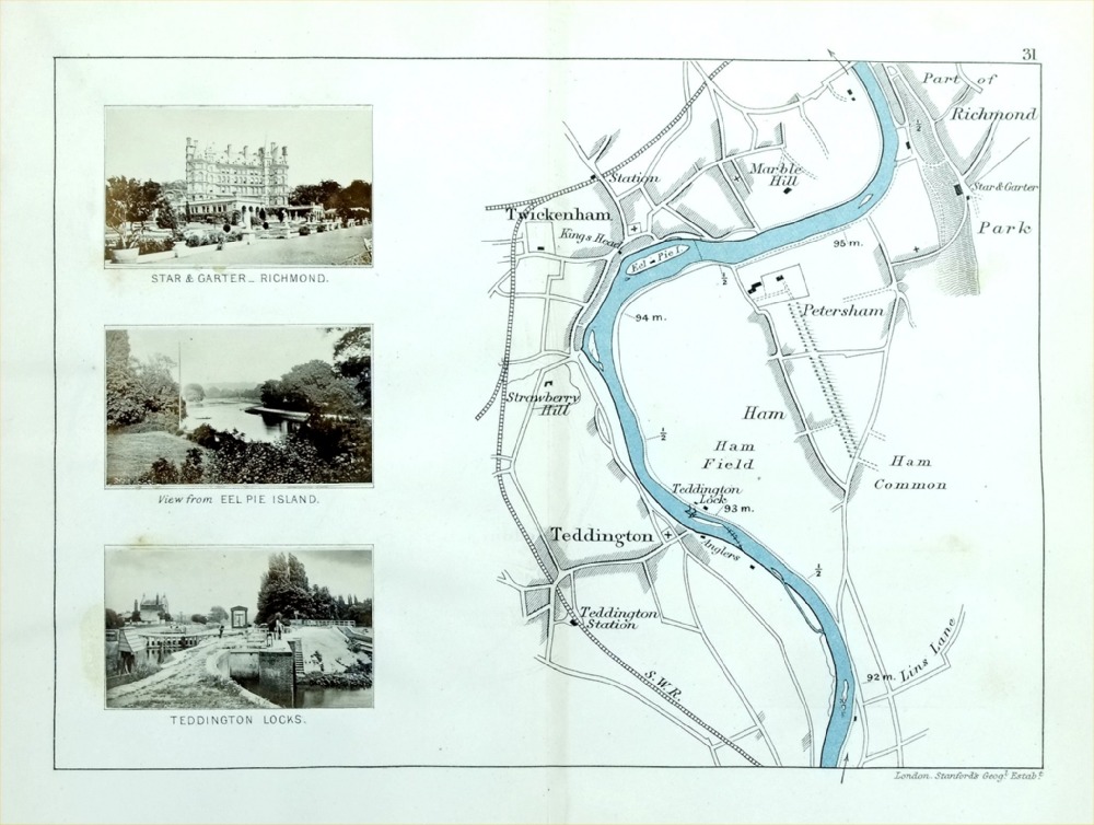
The Thames - Twickenham, Teddington, Petersham,
part of Richmond Henry Taunt 1897 - from Taunt's Illustrated Map of the Thames Inset are 3 miniature photographs of local views size : 220 x 160 mm - centre fold - some discolouration from photograph offest or adhesive. Ref PLM041 £18.00 (+P&P) click image for enlargement |
|
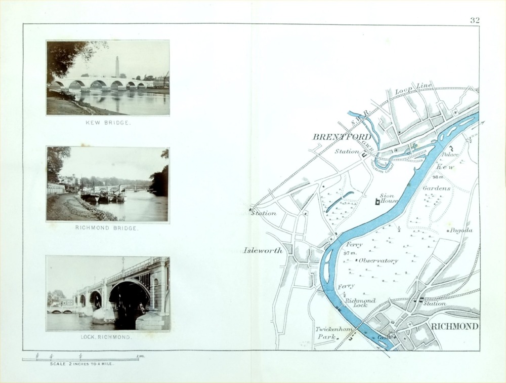
The Thames - Brentford, Richmond, Isleworth Henry Taunt 1897 - from Taunt's Illustrated Map of the Thames Inset are 3 miniature photographs of local views size : 220 x 160 mm - centre fold - some discolouration from photograph offest or adhesive. Ref PLM042 £18.00 (+P&P) click image for enlargement |
|
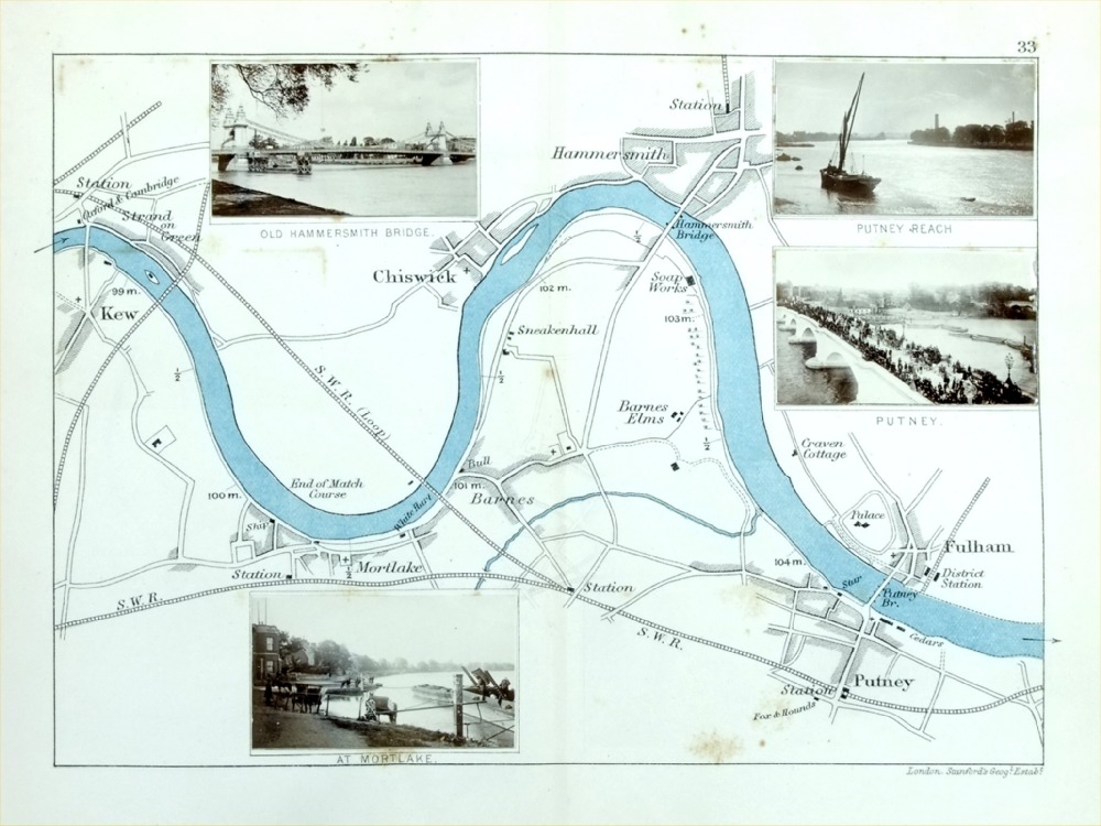
The Thames - Fulham, Putney, Chiswick,
Hammersmith, Mortlake, Kew Henry Taunt 1897 - from Taunt's Illustrated Map of the Thames Inset are 4 miniature photographs of local views size : 220 x 160 mm - centre fold - some discolouration from photograph offest or adhesive. Ref PLM043 £18.00 (+P&P) click image for enlargement |
| All Genuine Antiquarian Maps - No Reproductions or Modern Copies |
2023