Past Pages
Antique Maps, Prints and Ephemera
Charts, Tables, Statistics Chronology, Genealogy ....

 |
A Geographical and Statistical Table of England and Wales, Exhibiting in One View: The number of Cities, Market Towns and Parishes, with the extent of boundaries of each County,: the Population (in 1821 and 1831) ....... From James Duncan's 1833 atlas following the 1832 Reform Bill. 16 columns covering the counties of England & Wales. Detail 1 Detail 2 size: 400 x 470 mm, centre fold Ref LEE002 £22.00 (+P&P) click image for enlargement |
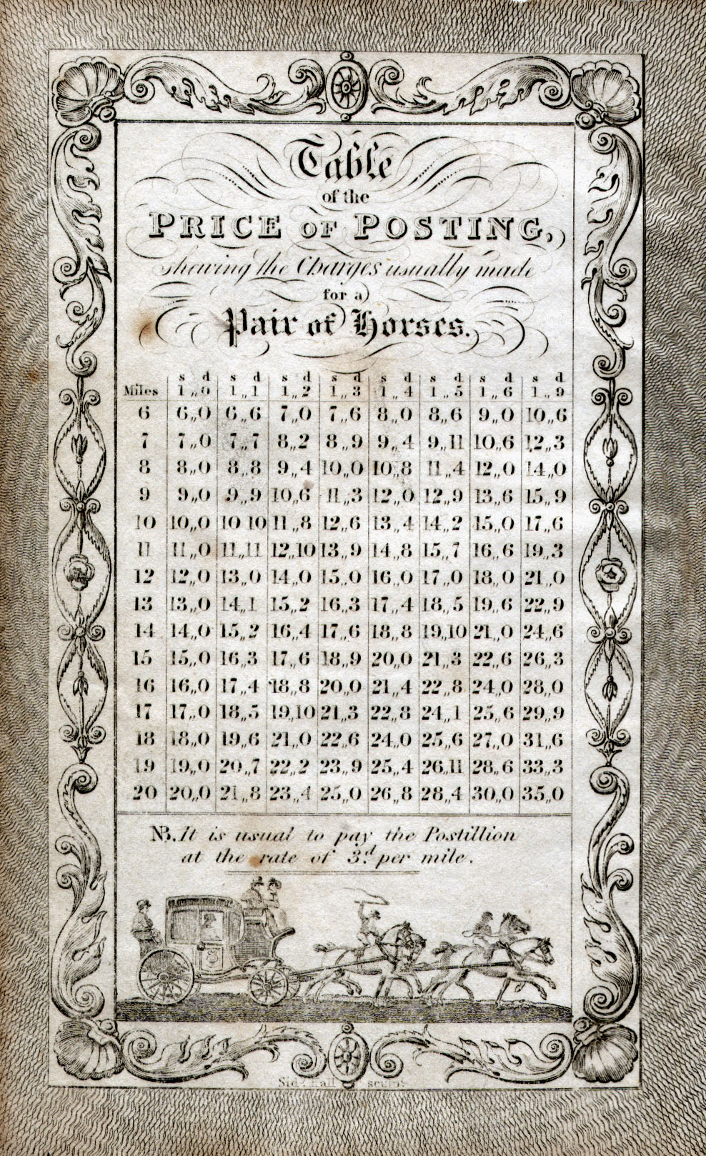 | Table of the Price of Posting, shewing the Charges
usually made for a Pair of Horses. Stage Coach fees in a simple table of rates from 1s0d to 1s9d per mile. Samuel Leigh / Sidney Hall 1837 size: 80 x130 mm a few spots of discolouration.. Ref GGE002 £38.00 (+P&P) click image for enlargement |
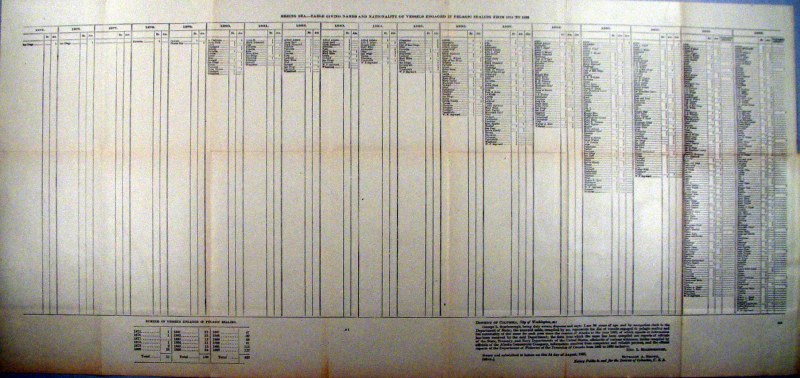 |
Table of ships engaged in Seal Hunting in the Bering
Sea between 1875 - 1892 Set of 3 charts. Detail 1 Detail 2 Table indicates ship's nationality and name United States Coast and Geodetic Survey 1892 Litho size: 790 x 350 mm Ref HLE002 £20.00 (+P&P) click image for enlargement |
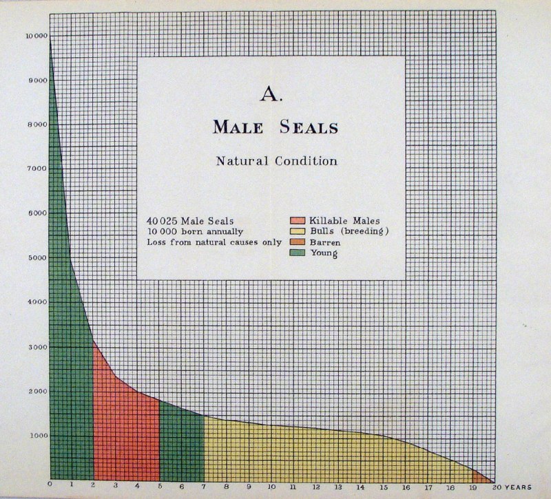 |
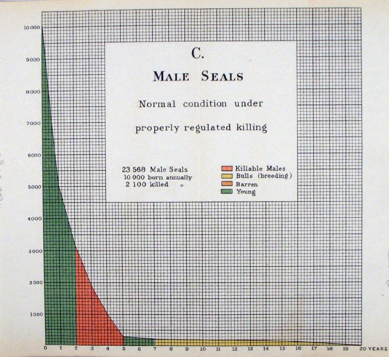
Statistical graph for the maintenance of seal colonies
after hunting. Set of 3 charts. Chart B Chart C United States Coast and Geodetic Survey 1895 X axis - size of seal colony or herd, Y axis - Age of seals. Litho size: 240 x 230 mm Ref HLE001 ( all 3 charts) £20.00 (+P&P) click image for enlargement |
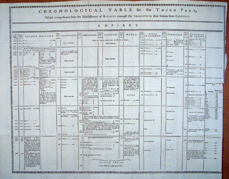 |
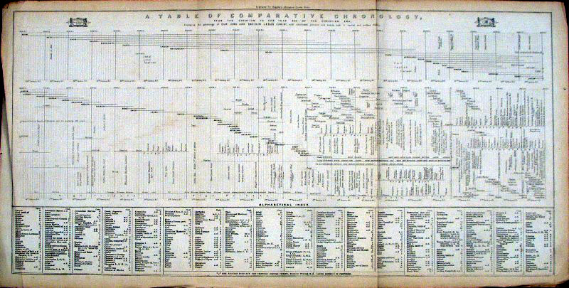
Biblical / Israelite Chronology Table
Donaldson 1761 size: 500 x 400 mm, several folds, tight right margin Ref HBE001 £28.00 (+P&P) Detail 1 Detail 2 Detail 3 click image for enlargement |
 |
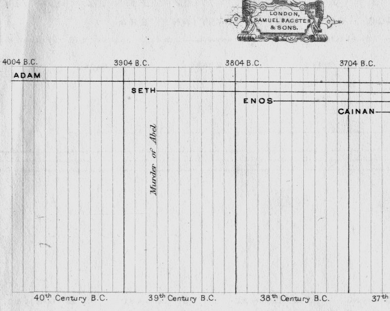
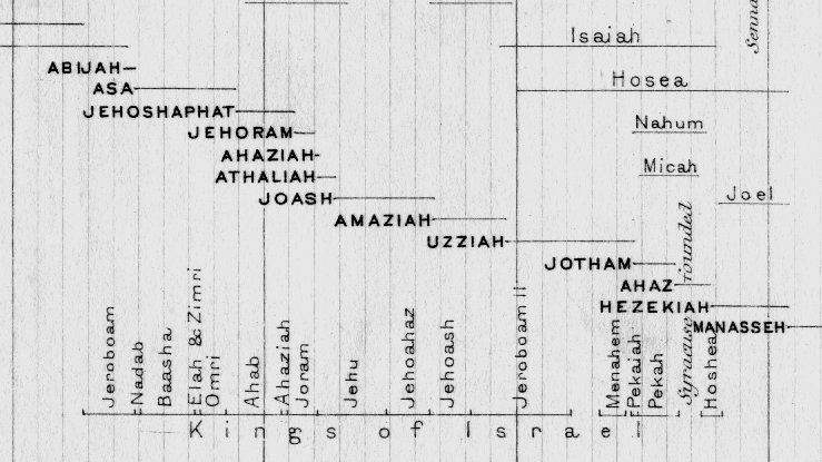
Biblical Chronology Table
Bagster 1847 size: 450 x 220 mm, 2 folds, creased margins Ref GDE001 £32.00 (+P&P) Detail 1 Detail 2 Detail 3 click image for enlargement |
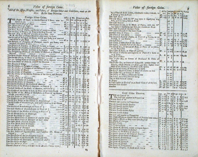 |
Table
of Value of Foreign Coins for the year 1753
(Gentlemans Magazine) size: 120 x 200 mm per page ' Table of the Assays, Weights and Values of Foreign Silver and Gold Coins made at the Mint. By Sir Isaac Newton.' Detail 1 Detail 2 Ref HEE003 £16.00 for all 3 pages (+P&P) click image for enlargement |
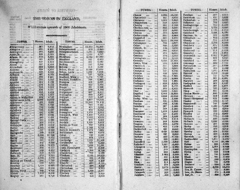 |
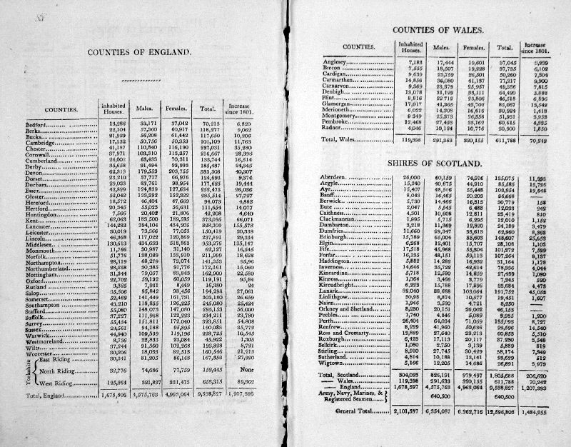
Population Returns of 1811 Capper 1813 8 pages of census returns for London, the Counties of England & Wales, the Shires of Scotland and all towns in England with over 2000 inhabitants. page size: 120 x 200 mm (illustration shows double page) Ref GDE002 £16.00 (+P&P) Another Page click image for enlargement |
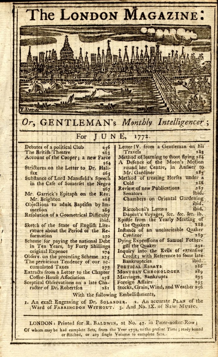
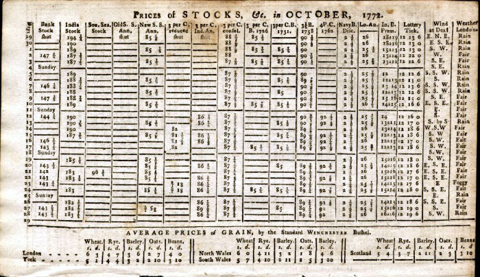 | Prices of Stocks for the year 1772
(London Magazine) size: 120 x 200 mm 12 pages of Stocks listings, Lottery winnings, Wind direction at Deal (Kent) and London Weather conditions for all of the year 1772. Illustration shows one typical month. This package of 12 sheets covers every day of 1772. Ref FGE001 £30.00 for all 12 pages (+P&P) click image for enlargement Typical Reverse Side |
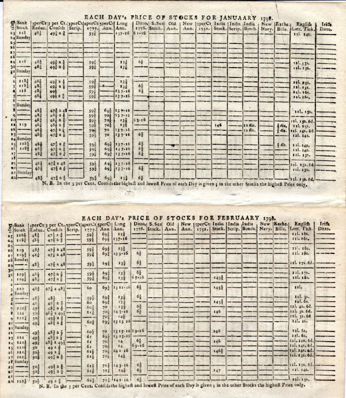 | Prices
of Stocks for the year 1798 (European Magazine
and London Review) size: 210 x 120 mm 6 pages of Stocks listings, County Court Sessions, Bills of Mortality, and Lottery winnings for the first half of the year 1798 Covers Jan 1798 to June 1798 Two pages shown Ref FLE002 £18.00 for all 6 pages (+P&P) click image for enlargement |
 | Table
of Corn Prices for the year 1798 (European
Magazine and London Review) size: 120 x 200 mm 6 pages of average corn prices in English counties (split into coastal and inland counties). The corn table lists Wheat, Rye, Barley , Oats and Beans for each county. The table of weather conditions for each day of the month lists air pressure, temperature and wind direction. Covers Jan 1798 to June 1798 Ref FLE001 £18.00 for all 6 pages (+P&P) click image for enlargement |
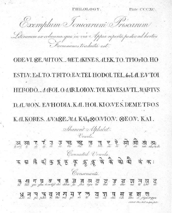 |
Philology
Andrew Bell c1780 Copper engraving size: 200 x 240 mm Ref GAP156 £24.00 (+P&P) click image for enlargement |
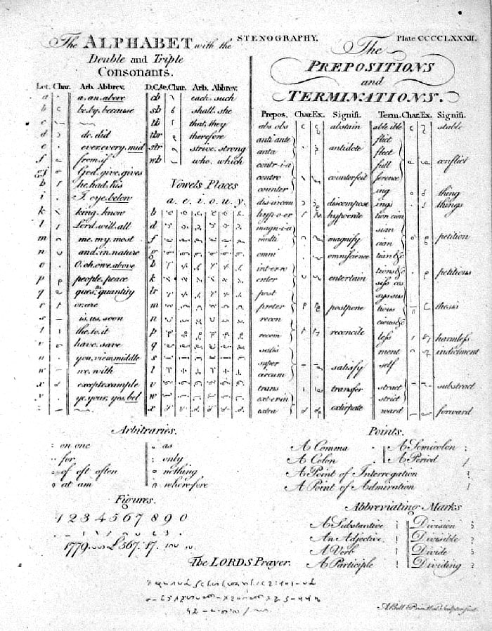 |
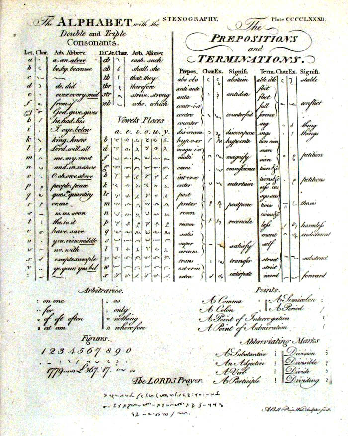
Stenography
Andrew Bell c1780 Copper engraving size: 200 x 240 mm Ref GAP206 £20.00 (+P&P) [ JCP032 ] click image for enlargement |
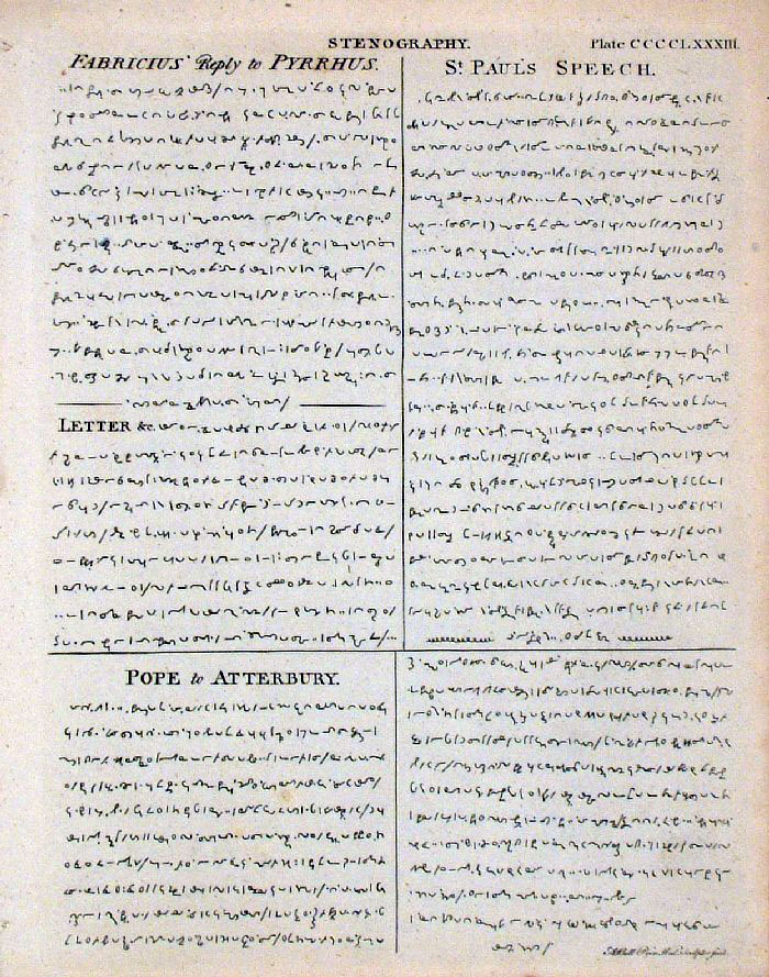 |
Stenography
Andrew Bell c1780 Copper engraving size: 200 x 240 mm Ref GAP207 £18.00 (+P&P) click image for enlargement |
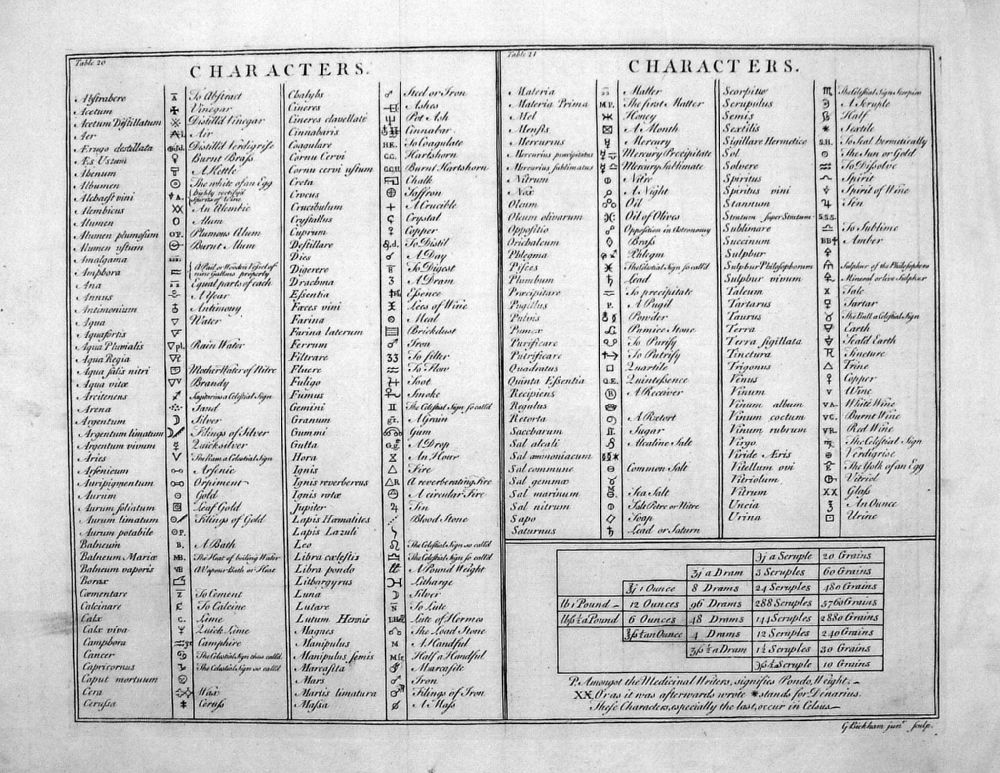 |
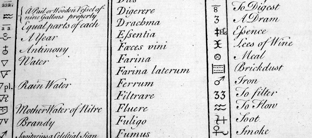
Table of Characters
Robert James 1743 Engraved by George Bickham for Robert James' "Medicinal Dictionary" - see Title Page Copper Engraving size: 410 x 340 mm, 3 folds, a few minor creases Ref LEP041 £25.00 (+P&P) Detail click image for enlargement- apologies for distortion in photography |
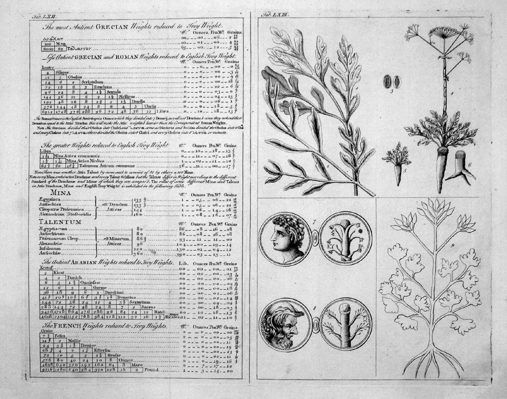 |
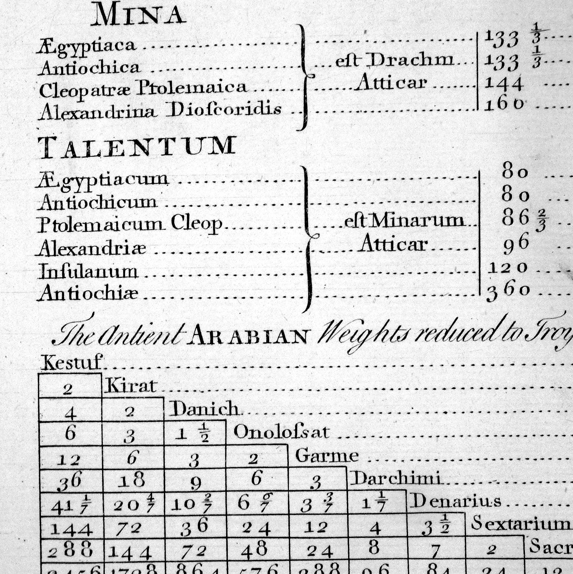
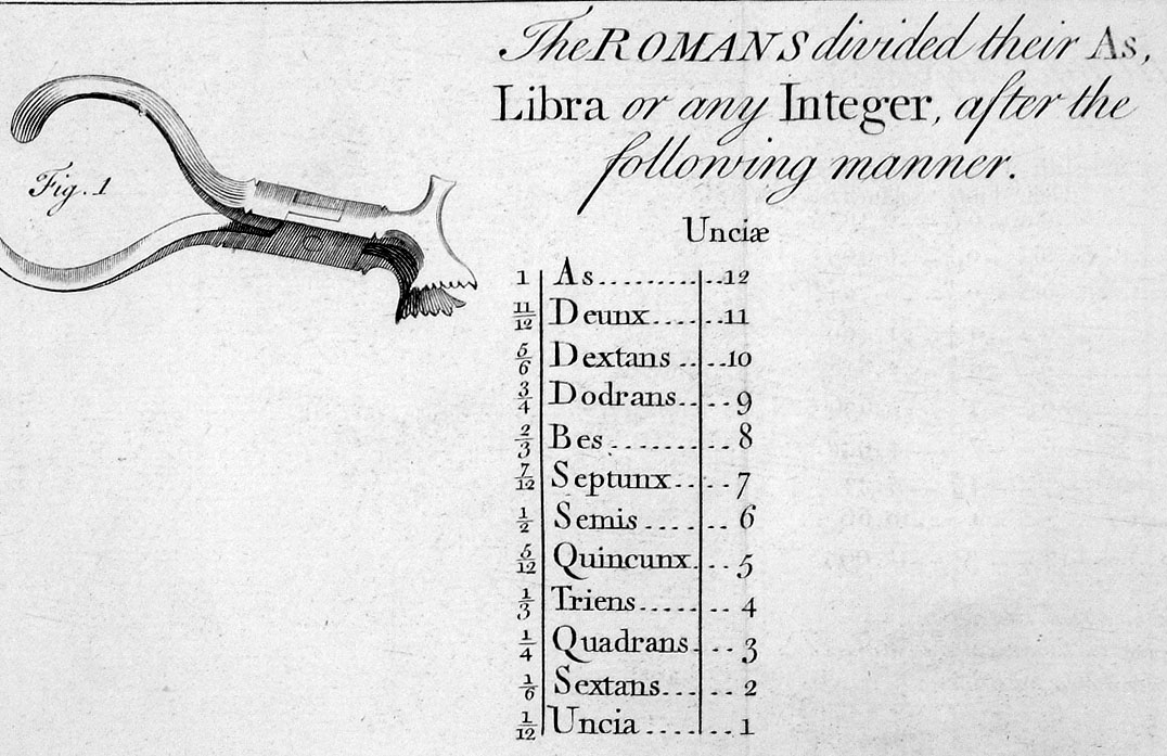
Table of Weights and Measures
Robert James 1743 Engraved by George Bickham for Robert James' "Medicinal Dictionary" - see Title Page Copper Engraving size: 410 x 340 mm, 3 folds, a few minor creases Ref LEP042 £25.00 (+P&P) Detail Detail click image for enlargement- apologies for distortion in photography |
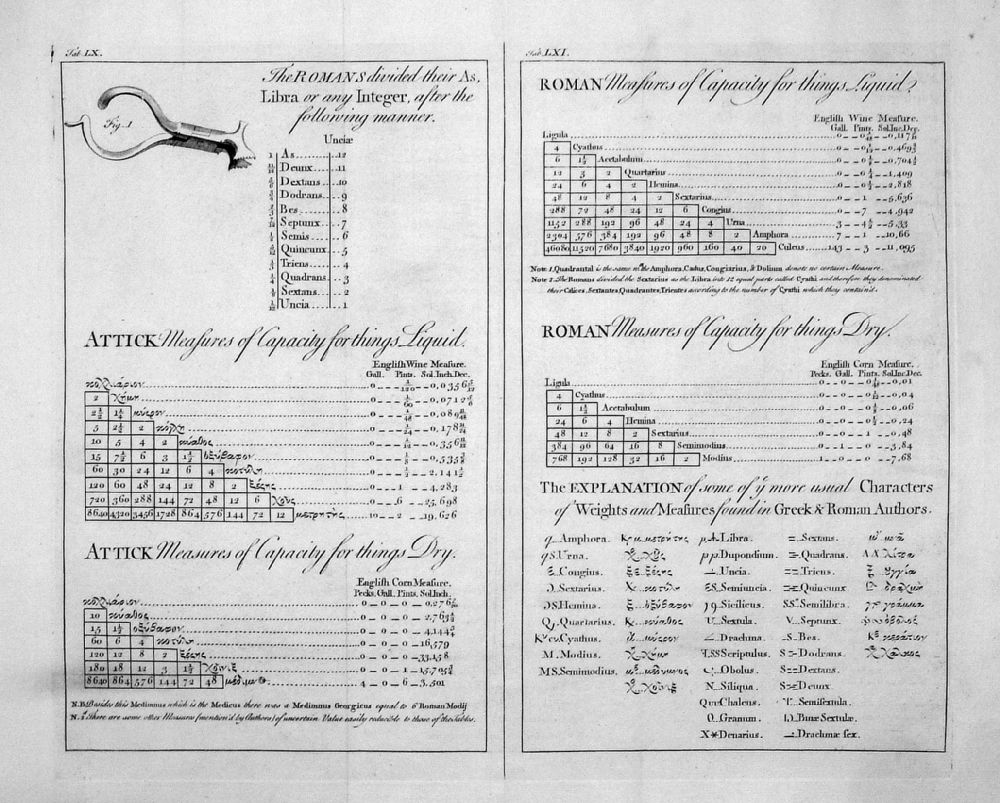 |
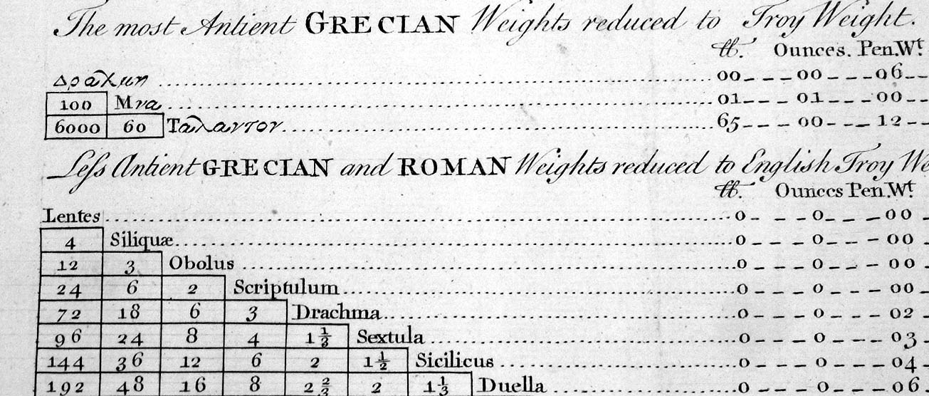
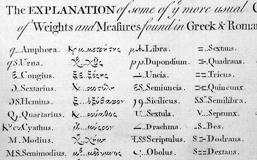
Table of Weights and Measures
Robert James 1743 Engraved by George Bickham for Robert James' "Medicinal Dictionary" - see Title Page Copper Engraving size: 410 x 340 mm, 3 folds, repair to split fold Ref LEP043 £25.00 (+P&P) Detail Detail Detail click image for enlargement- apologies for distortion in photography |
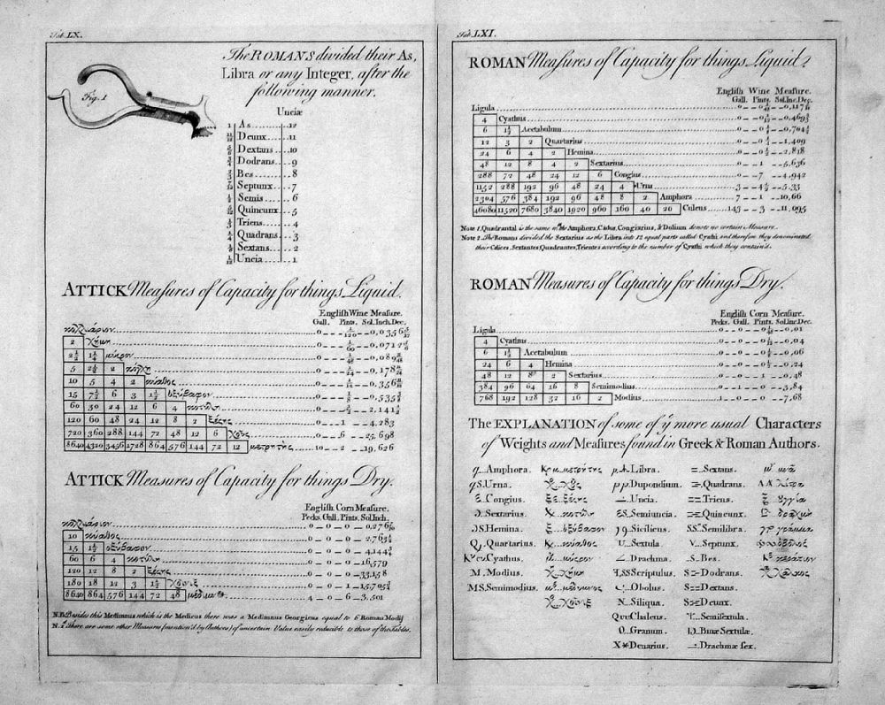 |
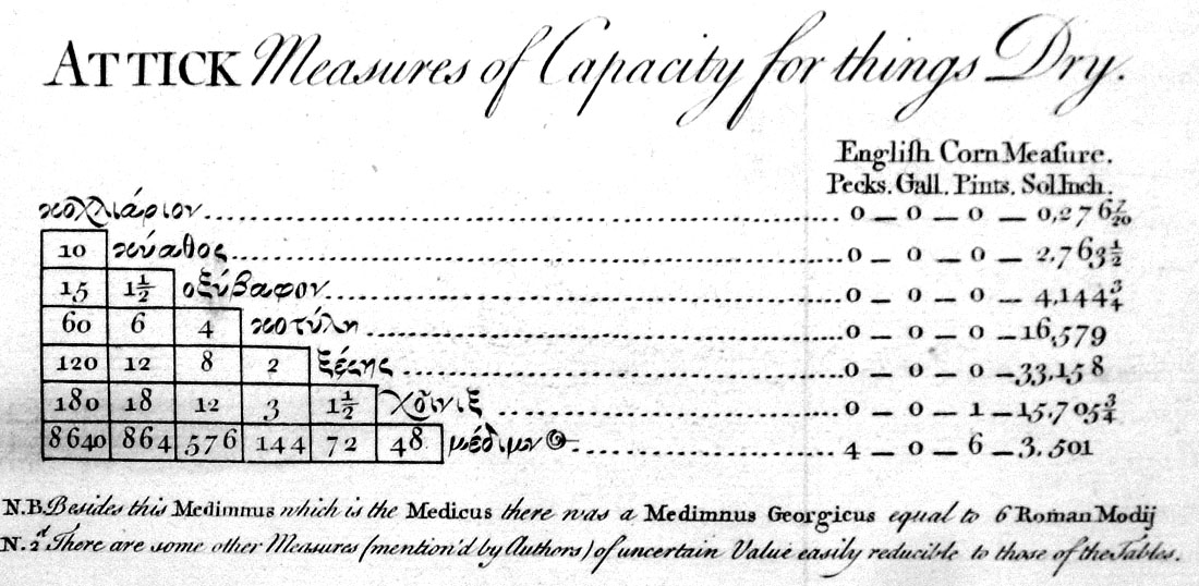
Table of Weights and Measures
Robert James 1743 Engraved by George Bickham for Robert James' "Medicinal Dictionary" - see Title Page Copper Engraving size: 410 x 340 mm, centre fold, minor creases Ref LEP044 £25.00 (+P&P) Detail Detail click image for enlargement- apologies for distortion in photography |
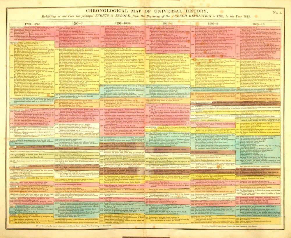 |
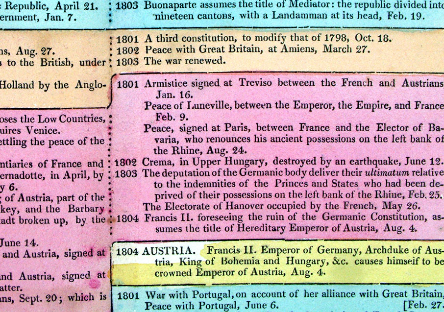
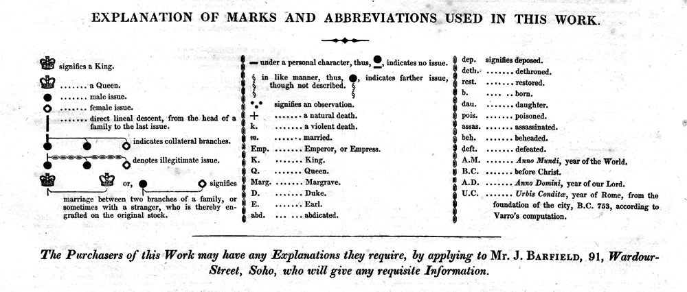
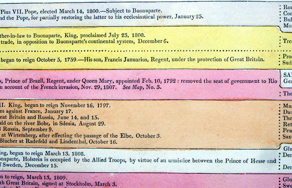
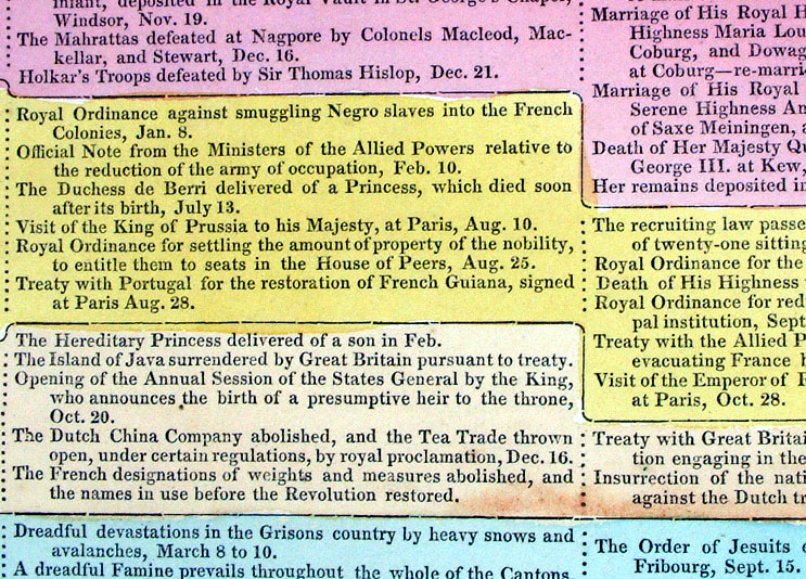
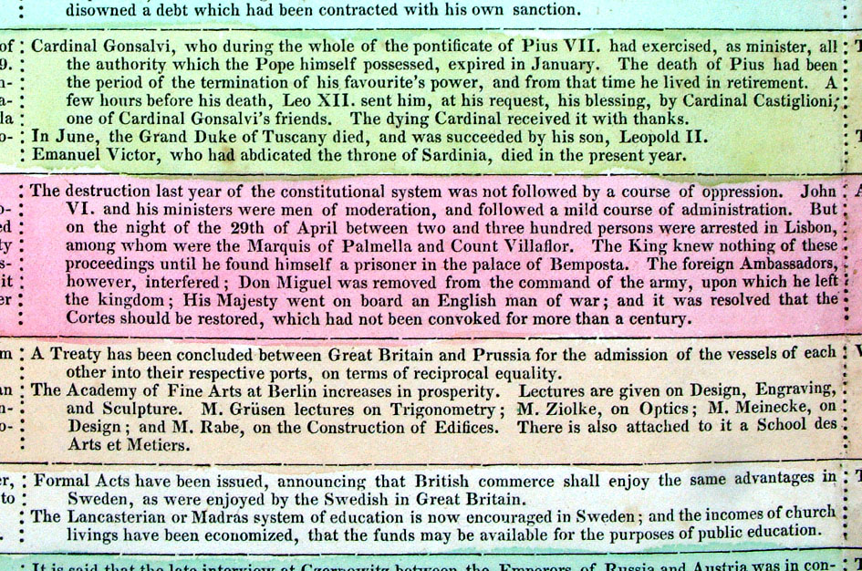
Chronological Map of Universal History Exhibiting at one View The principal Events in Europe from the beginning of the French Revolution in 1789 to the year 1813. From Lavoisne's Genealogical, Historical, Chronological and Geographical Atlas 1827 - Title Page Hand coloured at time of publication. Page size: 530 x 420 mm, centre fold. Some foxing spots. Ref LHM003 £24.00 (+P&P) Detail Key to Symbols in Chart click image for enlargement |
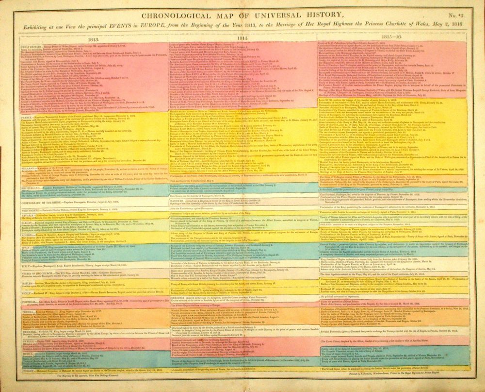 |
Chronological Map of Universal History Exhibiting at one View The principal Events in Europe from the beginning of the year 1813 to 1816 . From Lavoisne's Genealogical, Historical, Chronological and Geographical Atlas 1827 - Title Page Hand coloured at time of publication. Page size: 530 x 420 mm, centre fold. Ref LHM004 £24.00 (+P&P) Detail Key to Symbols in Chart click image for enlargement |
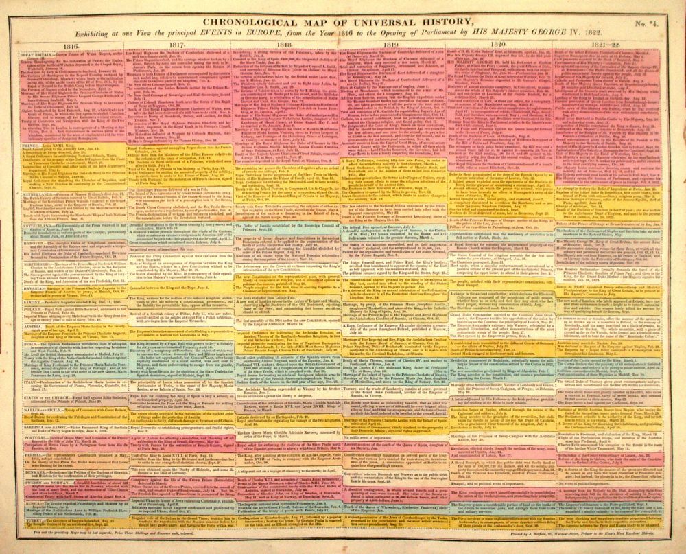 |
Chronological Map of Universal History Exhibiting at one View The principal Events in Europe from the beginning of the year 1816 to 1822 . From Lavoisne's Genealogical, Historical, Chronological and Geographical Atlas 1827 - Title Page Hand coloured at time of publication. Page size: 530 x 420 mm, centre fold. Ref LHM005 £24.00 (+P&P) Detail Key to Symbols in Chart click image for enlargement |
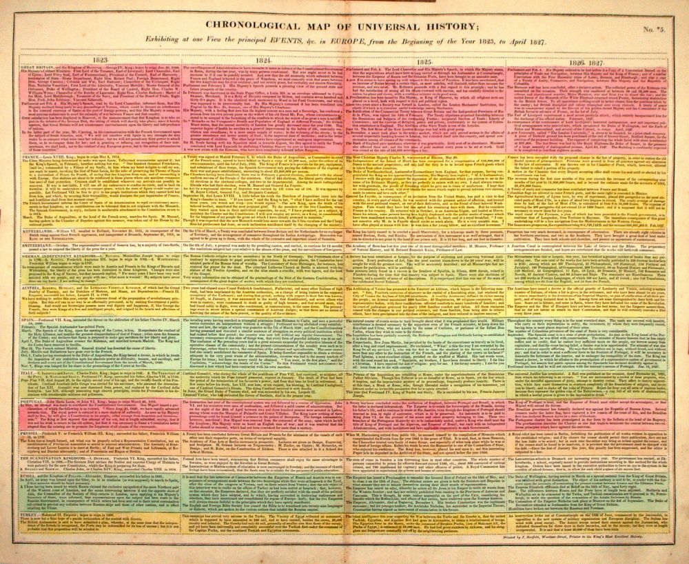 |
Chronological Map of Universal History Exhibiting at one View The principal Events in Europe from the beginning of the year 1823 to 1827 . From Lavoisne's Genealogical, Historical, Chronological and Geographical Atlas 1827 - Title Page Hand coloured at time of publication. Page size: 530 x 420 mm, centre fold. Ref LHM006 £24.00 (+P&P) Detail Key to Symbols in Chart click image for enlargement |
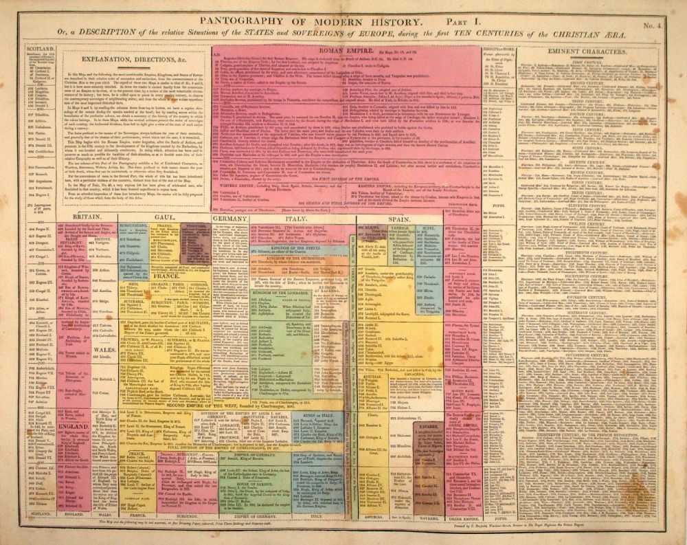 |
Pantography of Modern History - Part I or a Description of the Relative Situations of the States and Sovereigns of Europe during the First Ten Centuries of the Christian Era. From Lavoisne's Genealogical, Historical, Chronological and Geographical Atlas 1827 - Title Page Hand coloured at time of publication. Page size: 530 x 420 mm, centre fold. A few foxing spots. Ref LHM007 £24.00 (+P&P) Detail Key to Symbols in Chart click image for enlargement |
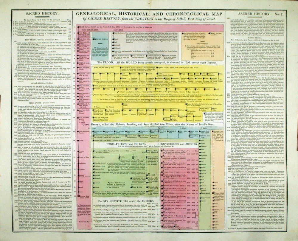 |
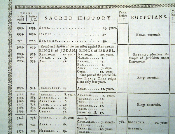
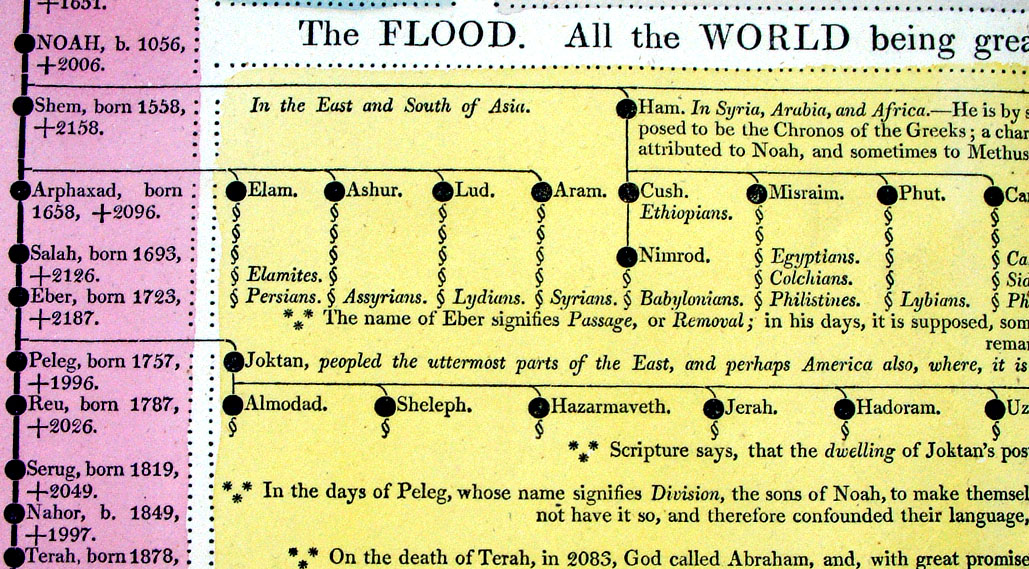
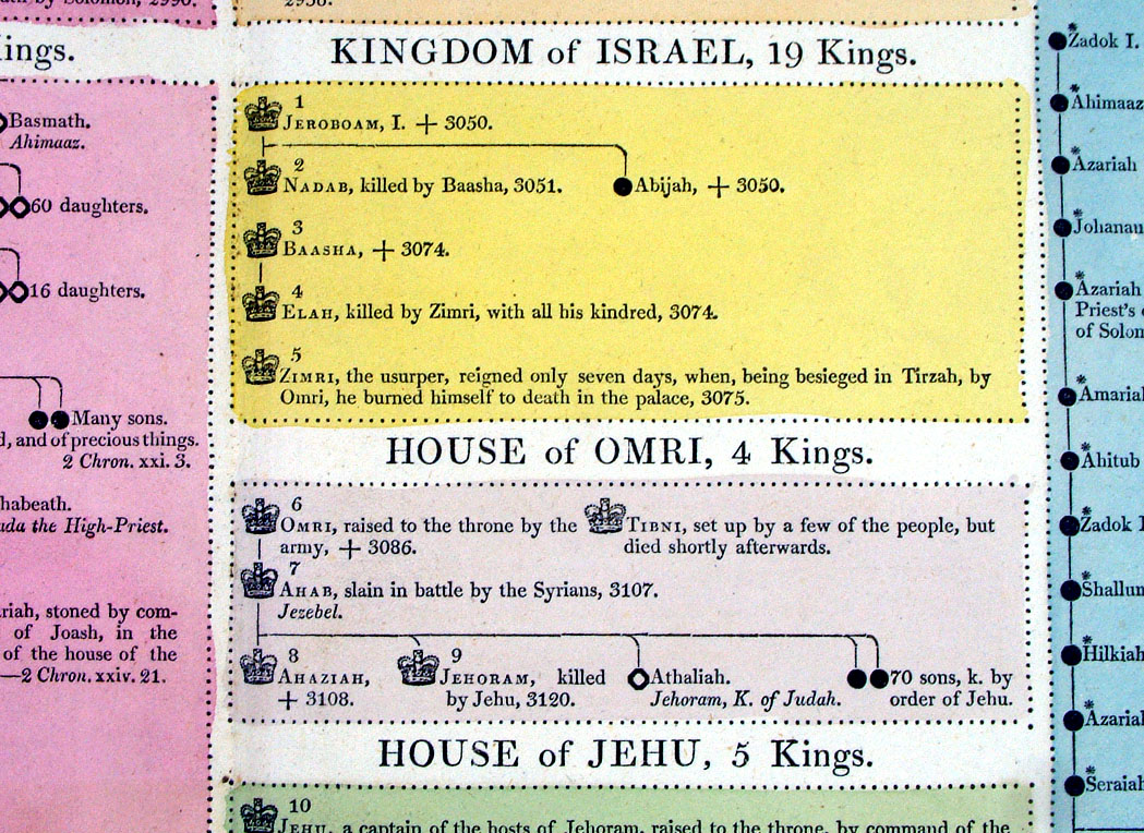
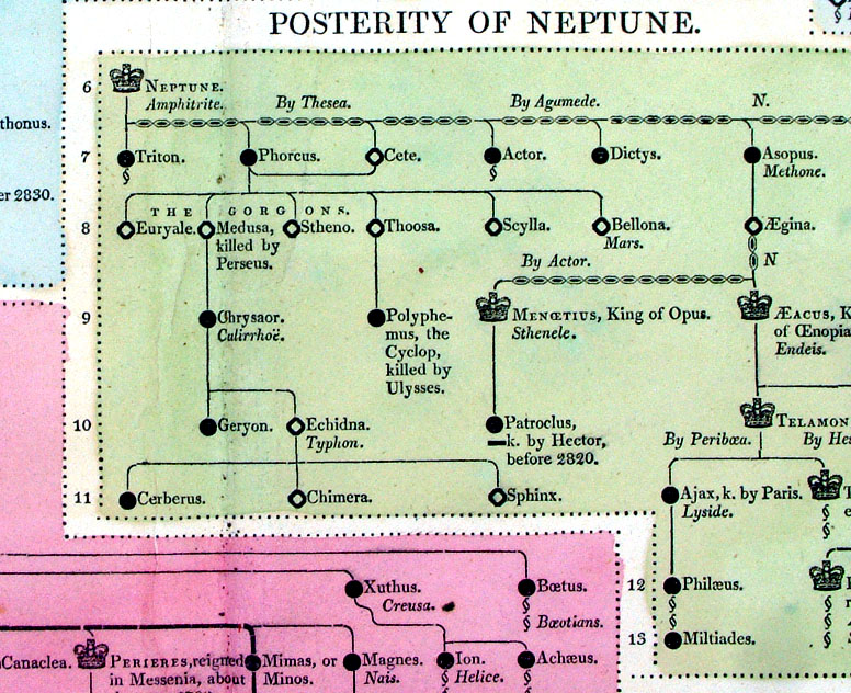
Genealogical, Historical and Chronological Map of Sacred History, From the Creation to the Reign of Saul, First King of Israel From Lavoisne's Genealogical, Historical, Chronological and Geographical Atlas 1827 - Title Page Hand coloured at time of publication. Page size: 530 x 420 mm, centre fold. Ref LHM010 £24.00 (+P&P) Detail Key to Symbols in Chart click image for enlargement |
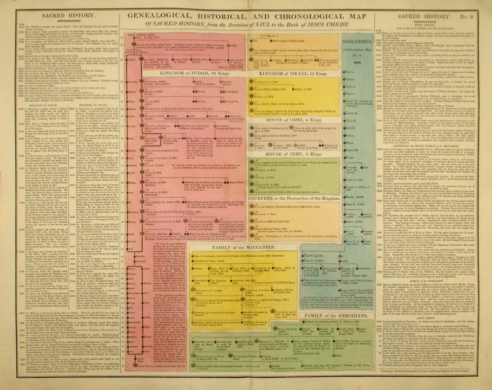 |
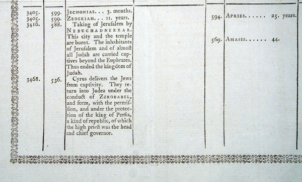
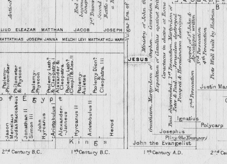
Genealogical, Historical and Chronological Map of Sacred History, From the Accession of Saul, to the Birth of Jesus Christ. From Lavoisne's Genealogical, Historical, Chronological and Geographical Atlas 1827 - Title Page Hand coloured at time of publication. Page size: 530 x 420 mm, centre fold. Ref LHM012 £24.00 (+P&P) Detail Key to Symbols in Chart click image for enlargement |
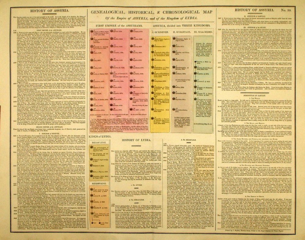 |
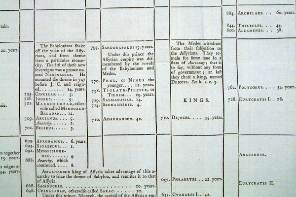
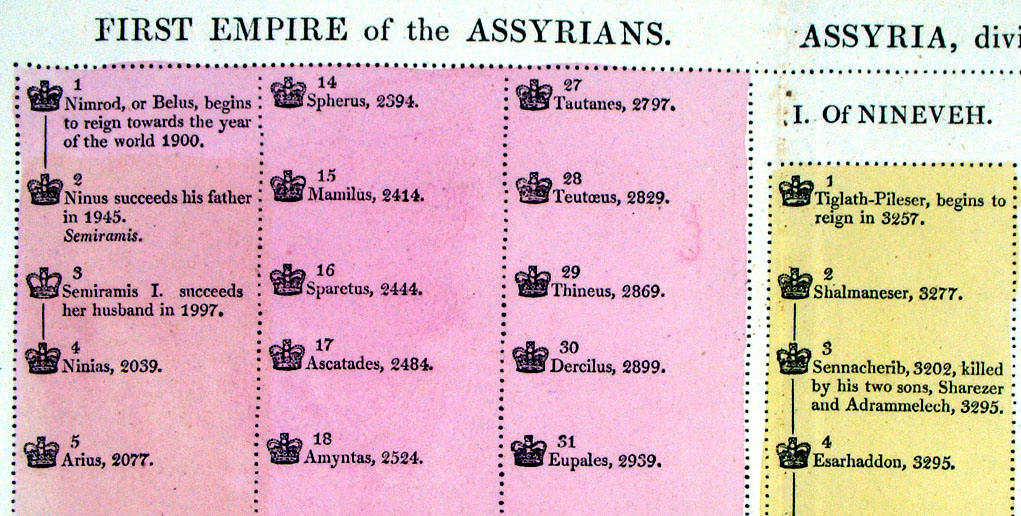
Genealogical, Historical and Chronological Map of the Empire of Assyria and of the Kingdom of Lydia. From Lavoisne's Genealogical, Historical, Chronological and Geographical Atlas 1827 - Title Page Hand coloured at time of publication. Page size: 530 x 420 mm, centre fold. Ref LHM013 £24.00 (+P&P) Detail Key to Symbols in Chart click image for enlargement |
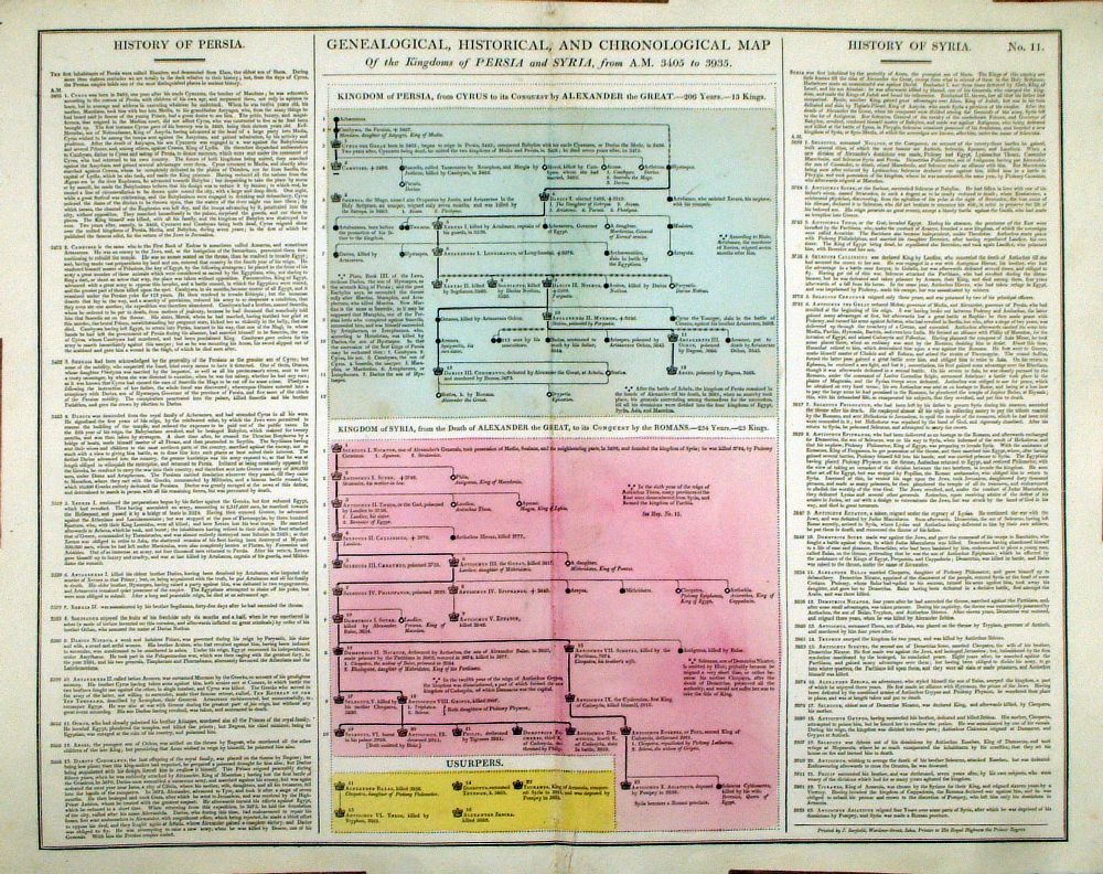 |
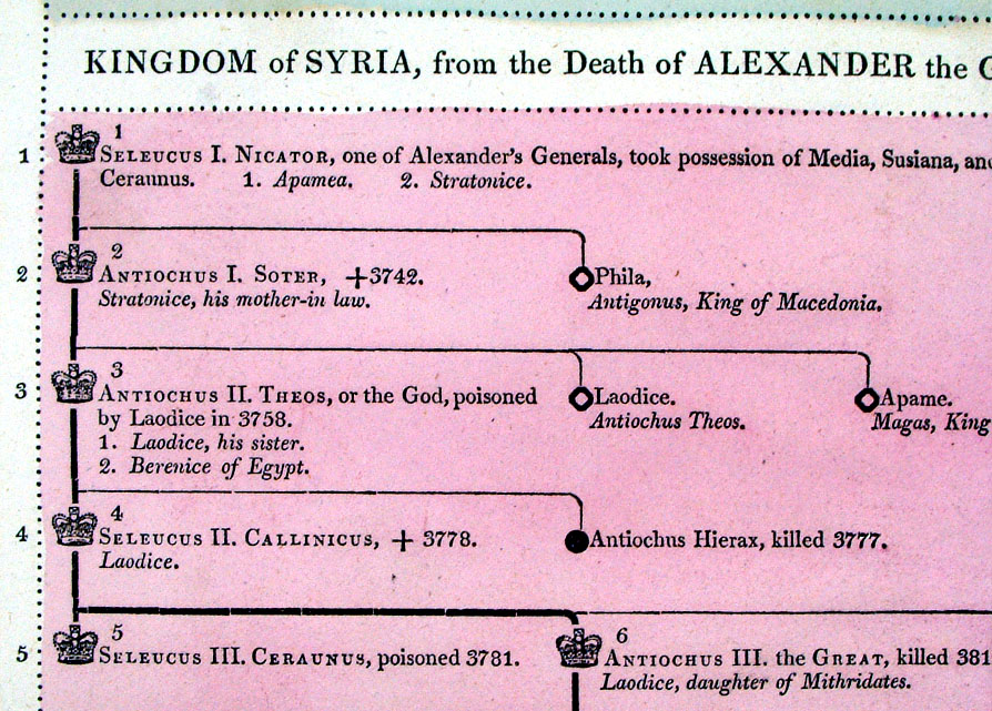
Genealogical, Historical and Chronological Map of the Kindoms of Persia and Syria from AM 3405 to 3935 From Lavoisne's Genealogical, Historical, Chronological and Geographical Atlas 1827 - Title Page Hand coloured at time of publication. Page size: 530 x 420 mm, centre fold. Ref LHM014 £24.00 (+P&P) Detail Key to Symbols in Chart click image for enlargement |
 |
Genealogical, Historical and Chronological Map of the Kindoms of Persia and Syria from AM 3405 to 3935 From Lavoisne's Genealogical, Historical, Chronological and Geographical Atlas 1827 - Title Page Hand coloured at time of publication. Page size: 530 x 420 mm, centre fold. Ref LHM015 £24.00 (+P&P) Detail Key to Symbols in Chart click image for enlargement |
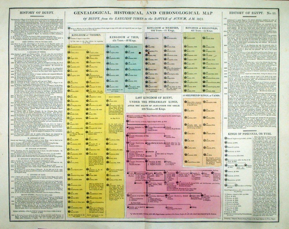 |
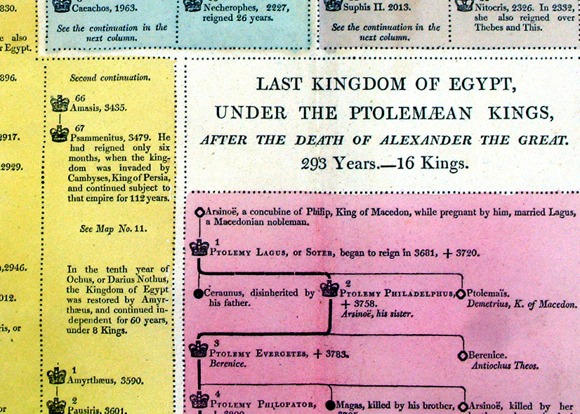
Genealogical, Historical and Chronological Map of Egypt from the earliest times to the Battle of Actium AM 3973 From Lavoisne's Genealogical, Historical, Chronological and Geographical Atlas 1827 - Title Page Hand coloured at time of publication. Page size: 530 x 420 mm, centre fold. Ref LHM016 £24.00 (+P&P) Detail Key to Symbols in Chart click image for enlargement |
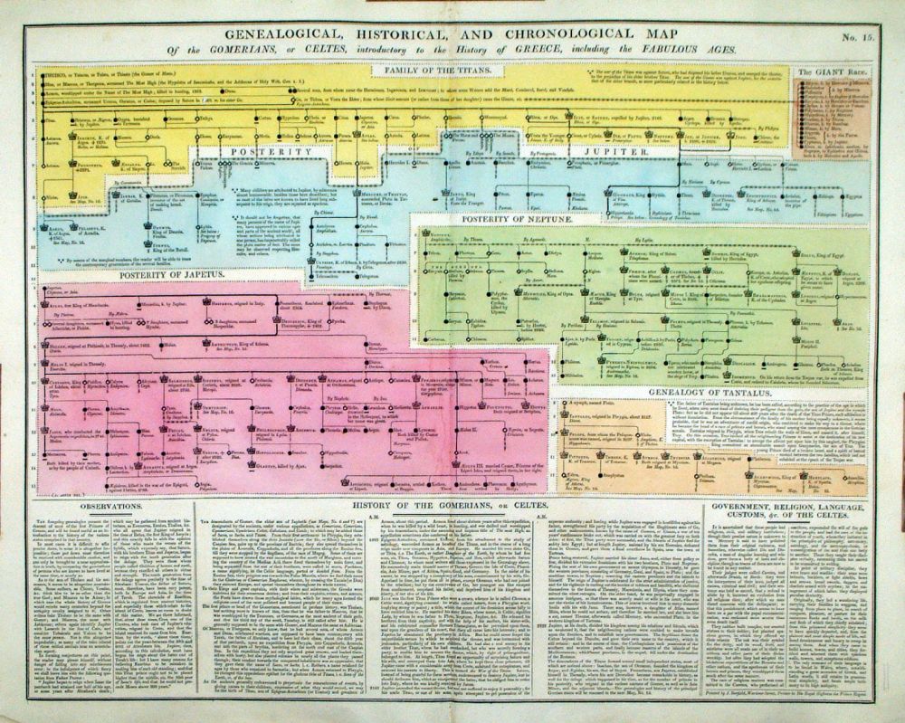 |
Genealogical, Historical and Chronological Map of the Gomerians or Celtes, introductory to the History of Greece From Lavoisne's Genealogical, Historical, Chronological and Geographical Atlas 1827 - Title Page Hand coloured at time of publication. Page size: 530 x 420 mm, centre fold. Ref LHM018 £24.00 (+P&P) Detail Key to Symbols in Chart click image for enlargement |
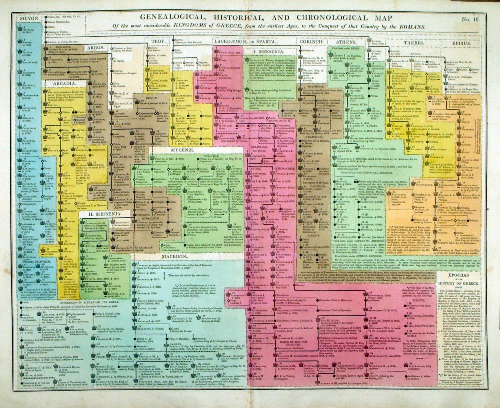 |
Genealogical, Historical and Chronological Map of the considerable Kingdoms of Greece to the Conquest by the Romans From Lavoisne's Genealogical, Historical, Chronological and Geographical Atlas 1827 - Title Page Hand coloured at time of publication. Page size: 530 x 420 mm, centre fold. Ref LHM019 £24.00 (+P&P) Detail Key to Symbols in Chart click image for enlargement |
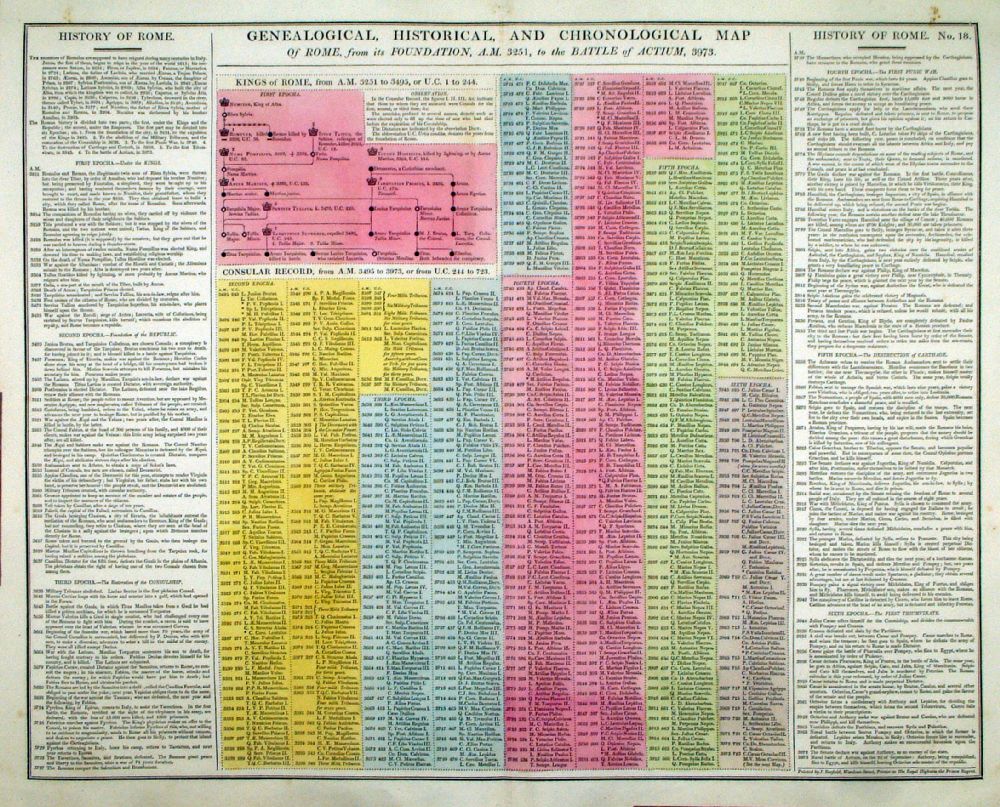 |
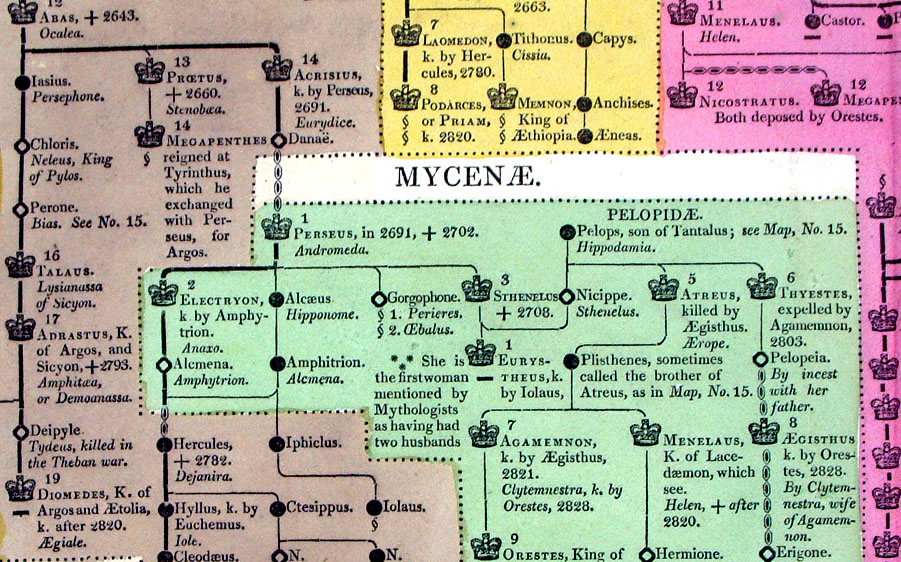
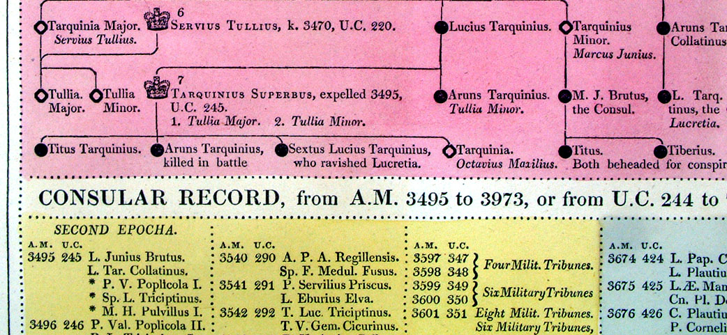
Genealogical, Historical and Chronological Map of Rome from its Foundations, AM 3251, to the Battle of Actium, AM3973 From Lavoisne's Genealogical, Historical, Chronological and Geographical Atlas 1827 - Title Page Hand coloured at time of publication. Page size: 530 x 420 mm, centre fold. Ref LHM021 £24.00 (+P&P) Detail Key to Symbols in Chart click image for enlargement |
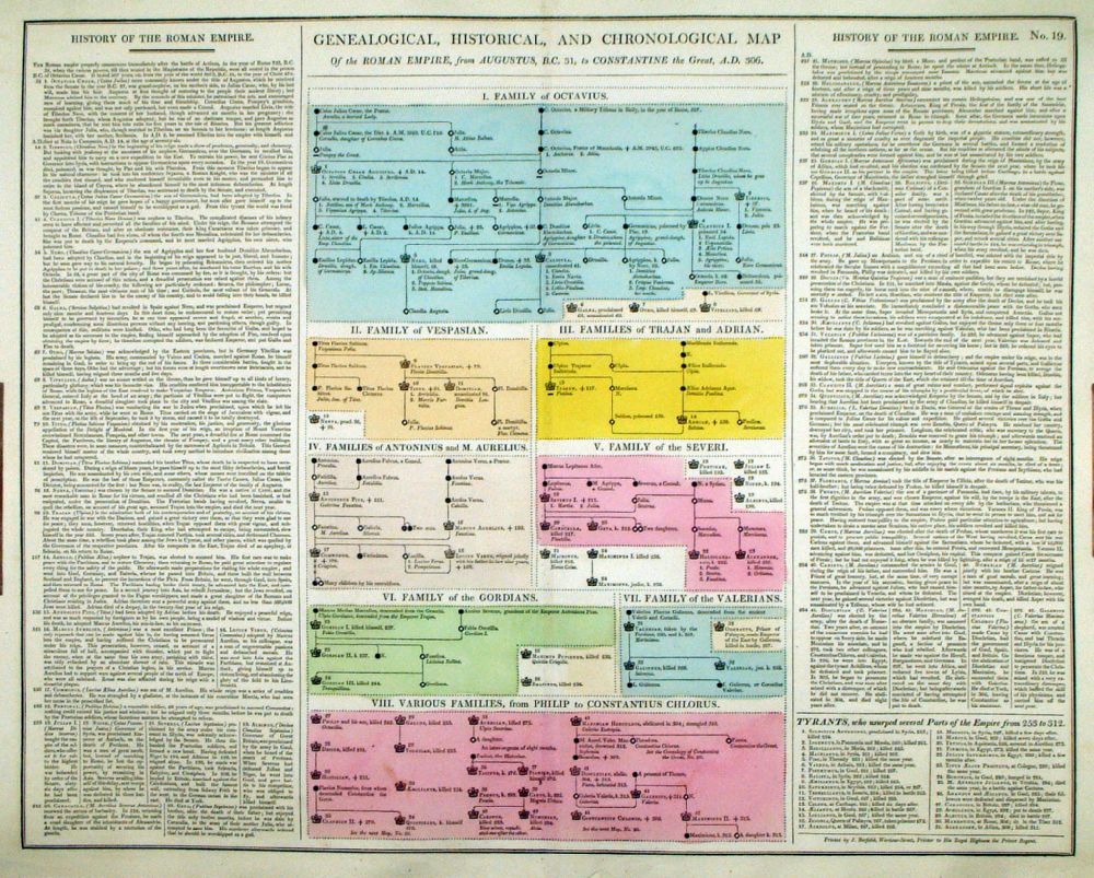 |
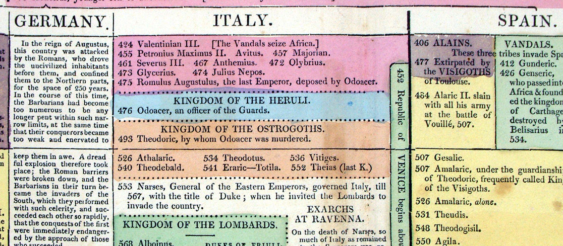
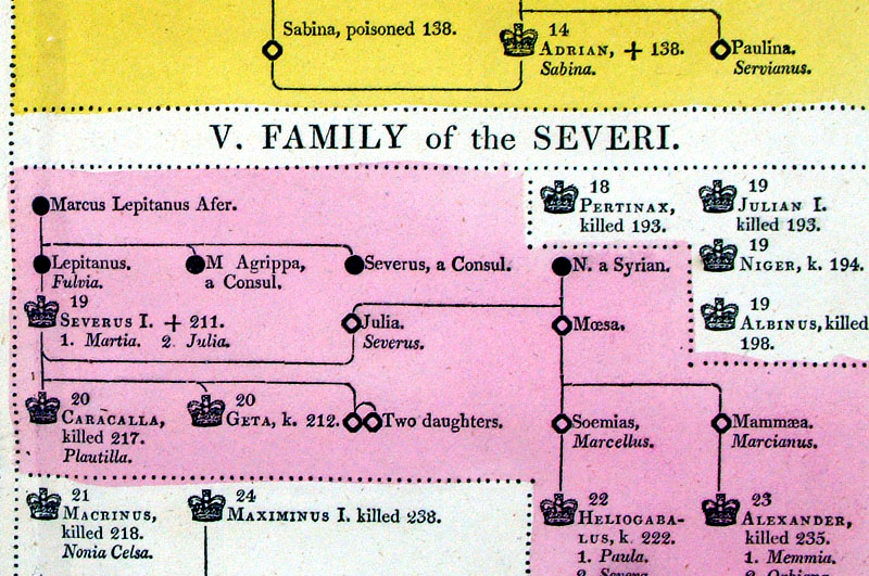
Genealogical, Historical and Chronological Map of Roman Empire from Augustus, BC 31, to Constantine the Great, AD 306 From Lavoisne's Genealogical, Historical, Chronological and Geographical Atlas 1827 - Title Page Hand coloured at time of publication. Page size: 530 x 420 mm, centre fold. Ref LHM022 £24.00 (+P&P) Detail Key to Symbols in Chart click image for enlargement |
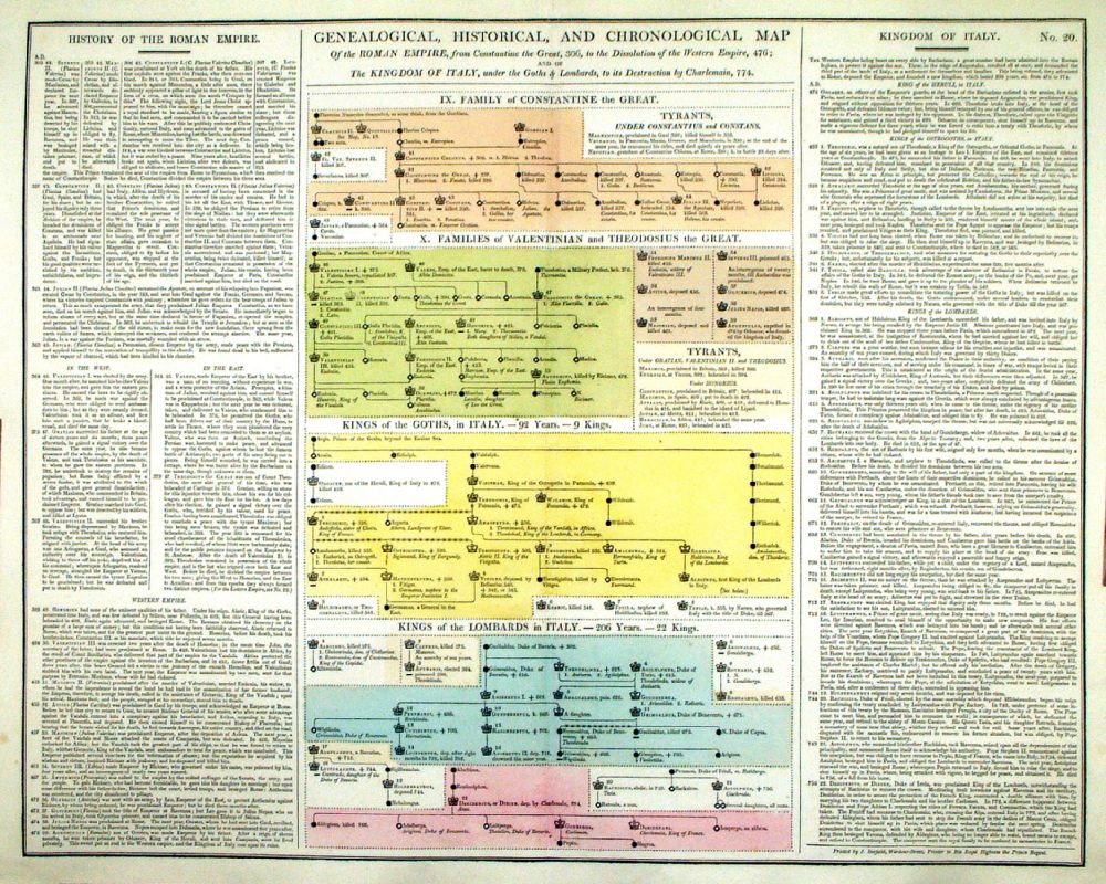 |
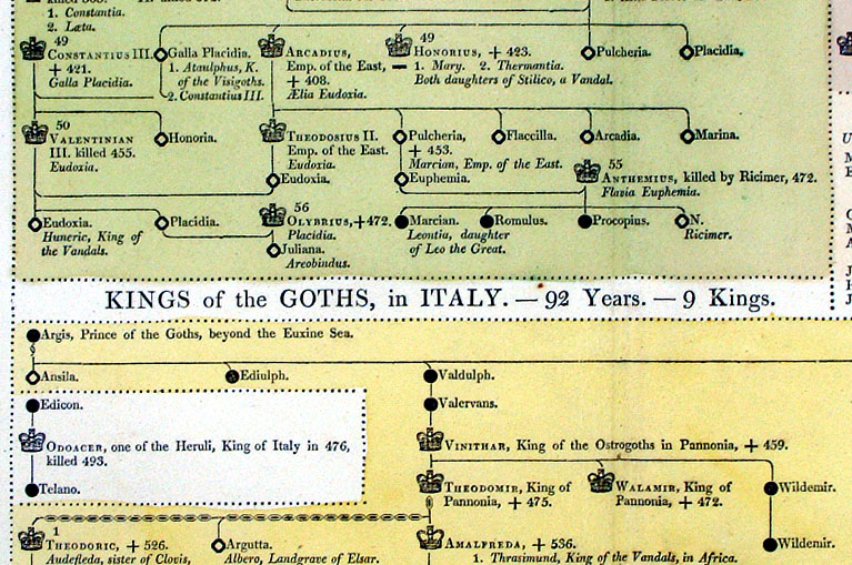
Genealogical, Historical and
Chronological Map of Roman Empire from Constantine the Great, AD 306, to
the Dissolution of the Western Empire. The Kingdom of Italy under the Goths and Lombards to its destruction by Charlemain, 774 From Lavoisne's Genealogical, Historical, Chronological and Geographical Atlas 1827 - Title Page Hand coloured at time of publication. Page size: 530 x 420 mm, centre fold. Ref LHM023 £24.00 (+P&P) Detail Key to Symbols in Chart click image for enlargement |
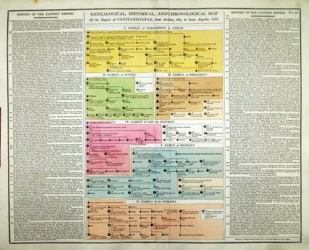 |
Genealogical, Historical and Chronological Map of the Empire of Constantinople from Arcadius, 395, to Isaac Angelus, 1185. From Lavoisne's Genealogical, Historical, Chronological and Geographical Atlas 1827 - Title Page Hand coloured at time of publication. Page size: 530 x 420 mm, centre fold - crease on right side. Ref LHM025 £24.00 (+P&P) Detail Key to Symbols in Chart click image for enlargement |
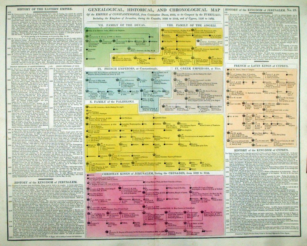 |
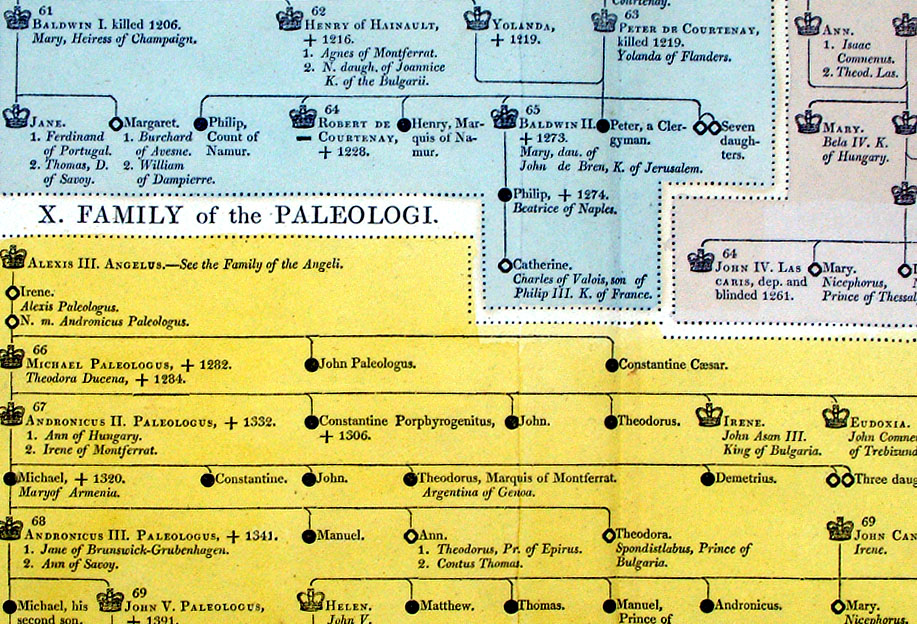
Genealogical, Historical and
Chronological Map of the Empire of Constantinople from Constantine
Ducas, 1059, to its conquest by the Turks. Including the Kingdoms of Jerusalem during the Crusades, 1099 to 1244, and of Cyprus, 1192 to 1489. From Lavoisne's Genealogical, Historical, Chronological and Geographical Atlas 1827 - Title Page Hand coloured at time of publication. Page size: 530 x 420 mm, centre fold. Ref LHM026 £24.00 (+P&P) Detail Key to Symbols in Chart click image for enlargement |
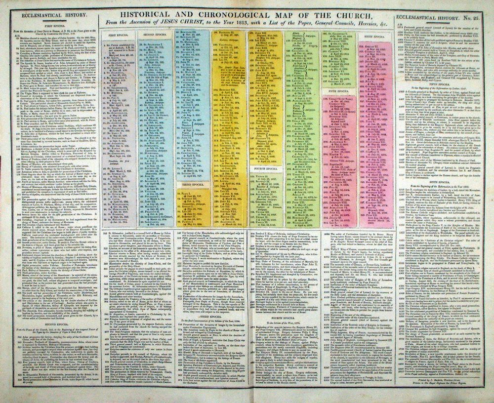 |
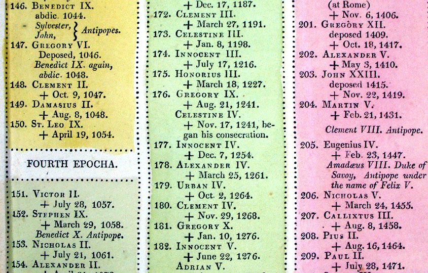
Genealogical, Historical and
Chronological Map of the Church from the Accession of Jesus Christ to
the year 1813 with the List of Popes .... From Lavoisne's Genealogical, Historical, Chronological and Geographical Atlas 1827 - Title Page Hand coloured at time of publication. Page size: 530 x 420 mm, centre fold. Ref LHM028 £24.00 (+P&P) Detail Key to Symbols in Chart click image for enlargement |
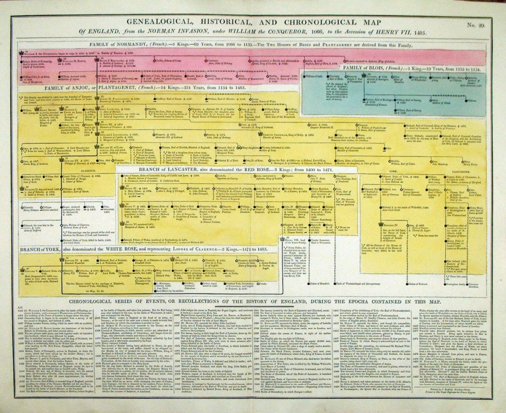 |
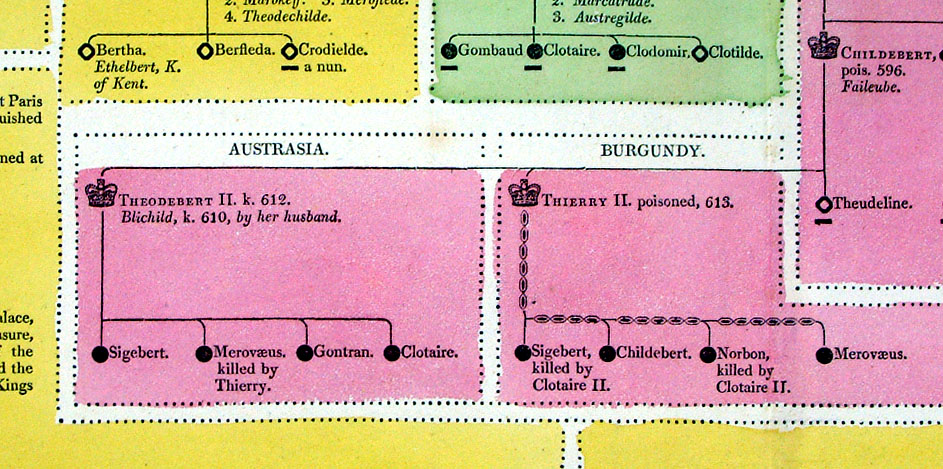
Genealogical, Historical and Chronological Map of England from the Norman Invasion to the Accession of Henry VII, 1485 From Lavoisne's Genealogical, Historical, Chronological and Geographical Atlas 1827 - Title Page Hand coloured at time of publication. Page size: 530 x 420 mm, centre fold. Ref LHM032 £24.00 (+P&P) Detail Key to Symbols in Chart click image for enlargement |
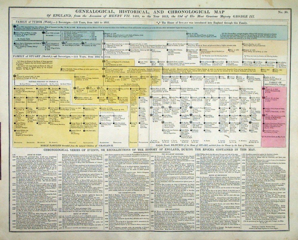 |
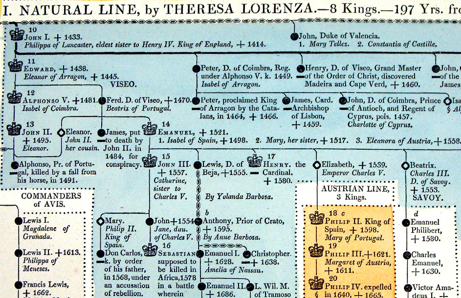
Genealogical, Historical and Chronological Map of England from the Accession of Henry VII, 1485, to the year 1813 From Lavoisne's Genealogical, Historical, Chronological and Geographical Atlas 1827 - Title Page Hand coloured at time of publication. Page size: 530 x 420 mm, centre fold. Ref LHM033 £24.00 (+P&P) Detail Key to Symbols in Chart click image for enlargement |
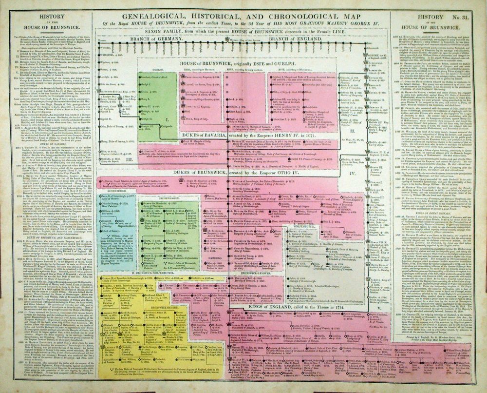 |
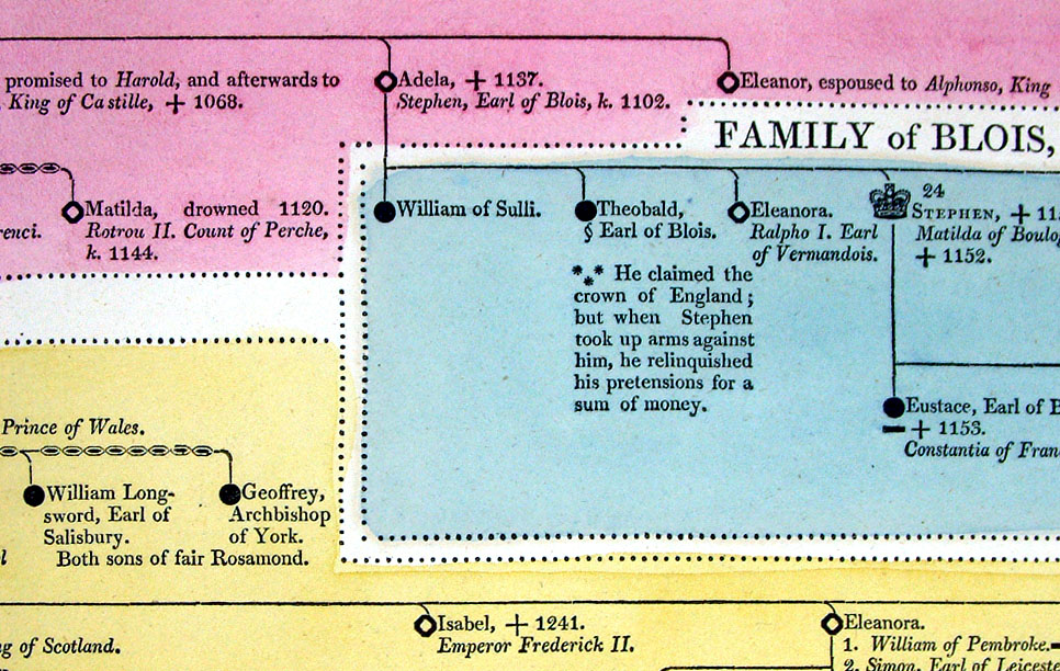
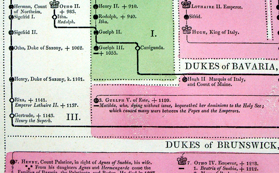
Genealogical, Historical and Chronological Map of the House of Brunswick, from the earliest times to the 3rd year of George IV From Lavoisne's Genealogical, Historical, Chronological and Geographical Atlas 1827 - Title Page Hand coloured at time of publication. Page size: 530 x 420 mm, centre fold, a few minor spots.. Ref LHM034 £24.00 (+P&P) Detail Key to Symbols in Chart click image for enlargement |
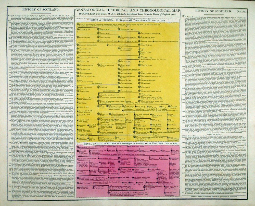 |
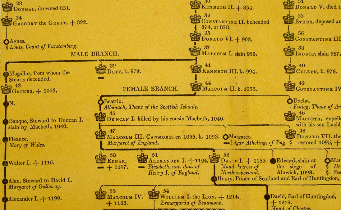
Genealogical, Historical and Chronological Map of Scotland from Fergus II, AD 404, to 1603 Top Table - House of Fergus. Bottom Table - House of Stewart. From Lavoisne's Genealogical, Historical, Chronological and Geographical Atlas 1827 - Title Page Hand coloured at time of publication. Page size: 530 x 420 mm, centre fold. Ref LHM036 £24.00 (+P&P) Detail Key to Symbols in Chart click image for enlargement |
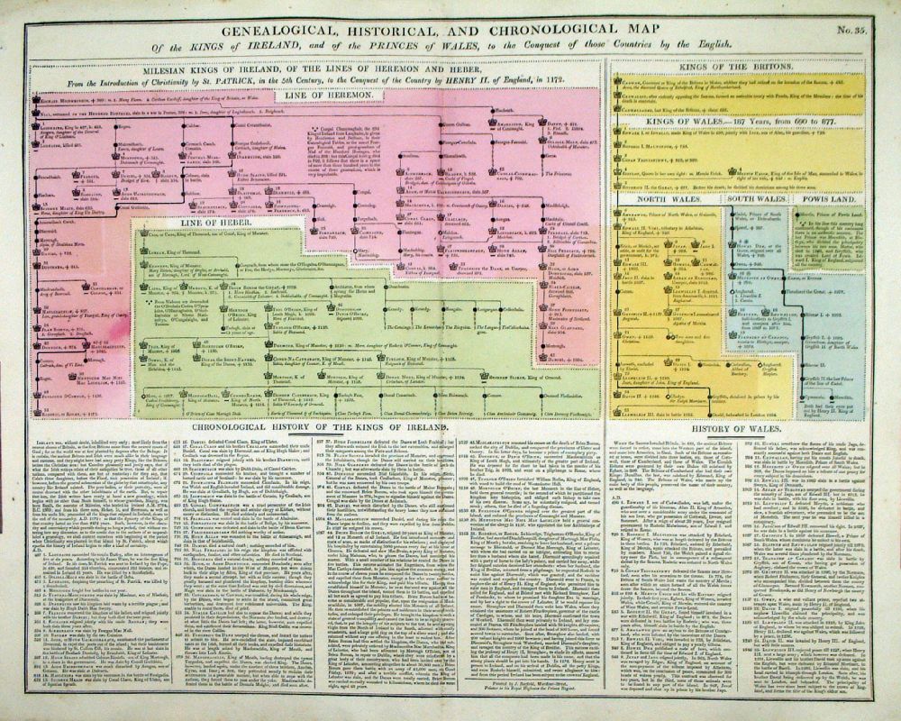 |
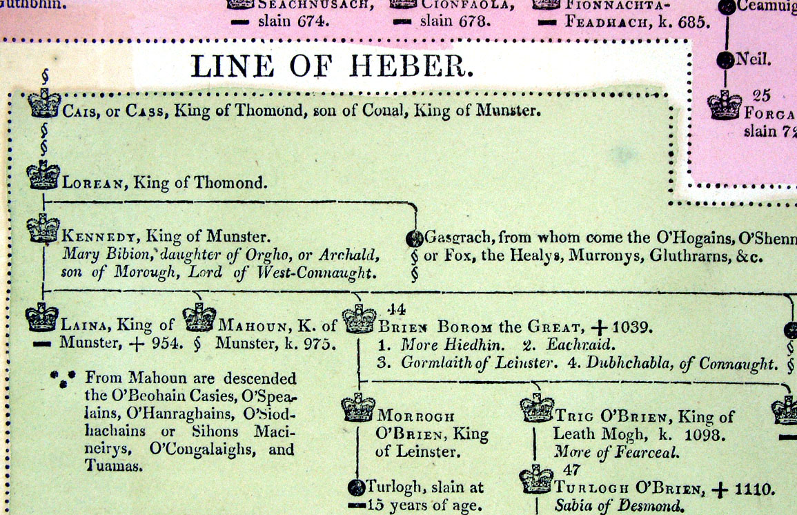
Genealogical, Historical and
Chronological Map of the Kings of Ireland and the Princes of Wales to
the Conquest of those countries by England. From Lavoisne's Genealogical, Historical, Chronological and Geographical Atlas 1827 - Title Page Hand coloured at time of publication. Page size: 530 x 420 mm, centre fold. Ref LHM038 £24.00 (+P&P) Detail Key to Symbols in Chart click image for enlargement |
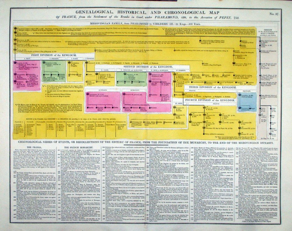 |
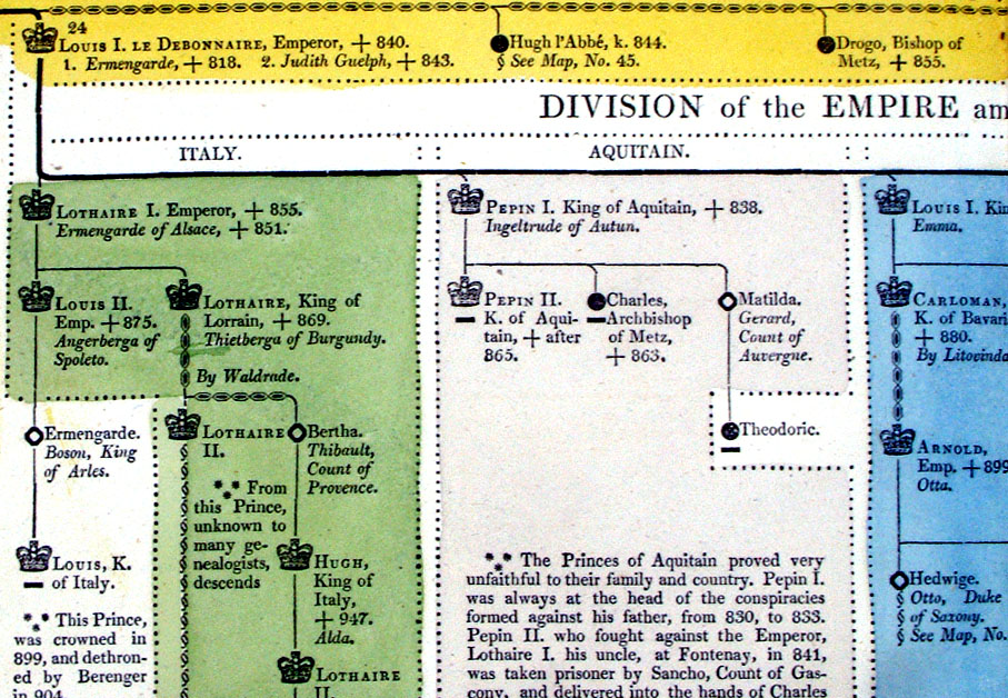
Genealogical, Historical and
Chronological Map of France, from the settlement of the Franks in Gaul,
under Pharamond, 420, to 752 From Lavoisne's Genealogical, Historical, Chronological and Geographical Atlas 1827 - Title Page Hand coloured at time of publication. Page size: 530 x 420 mm, centre fold. Ref LHM041 £24.00 (+P&P) Detail Key to Symbols in Chart click image for enlargement |
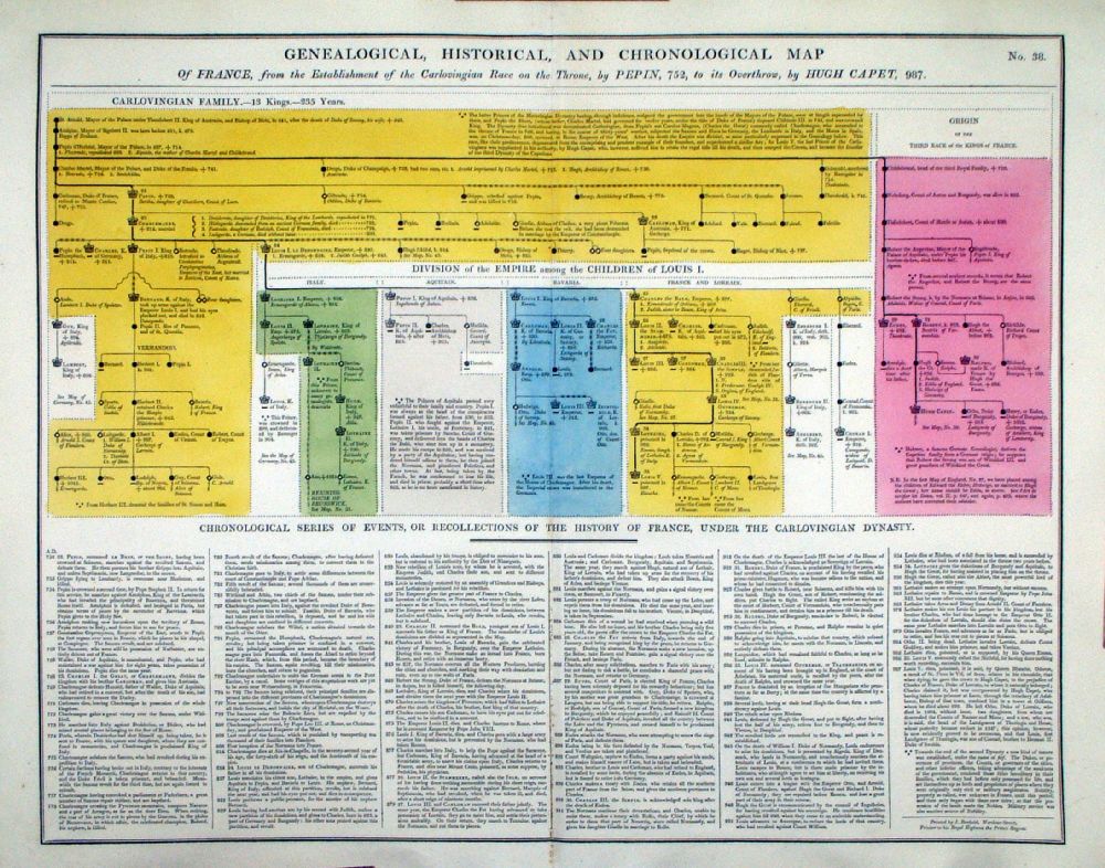 |
Genealogical, Historical and Chronological Map of France, from Pepin, 752 to Capet, 987. From Lavoisne's Genealogical, Historical, Chronological and Geographical Atlas 1827 - Title Page Hand coloured at time of publication. Page size: 530 x 420 mm, centre fold. Ref LHM042 £24.00 (+P&P) Detail Key to Symbols in Chart click image for enlargement |
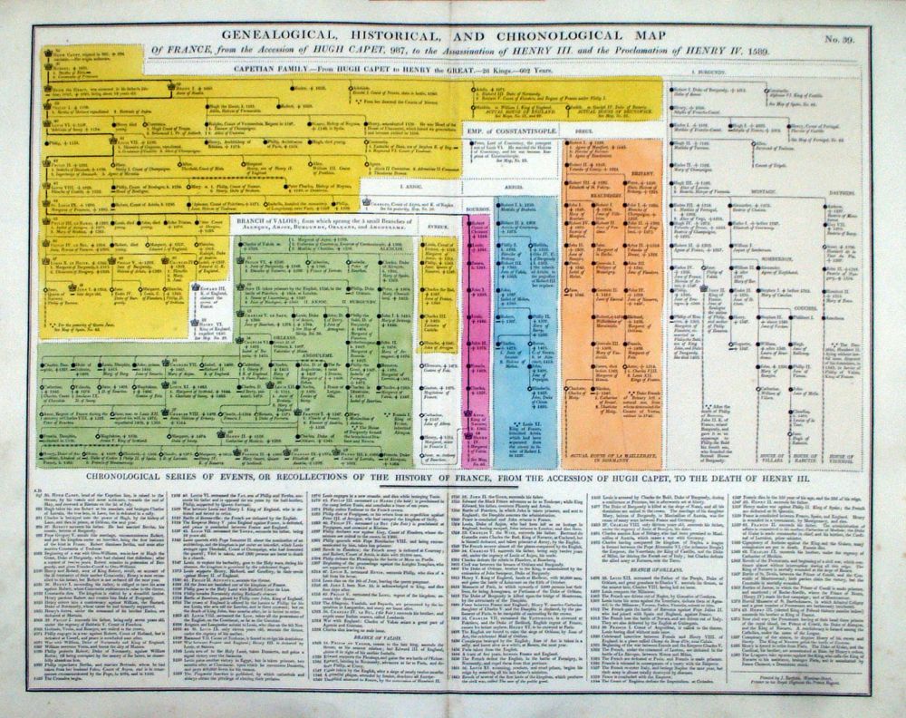 |
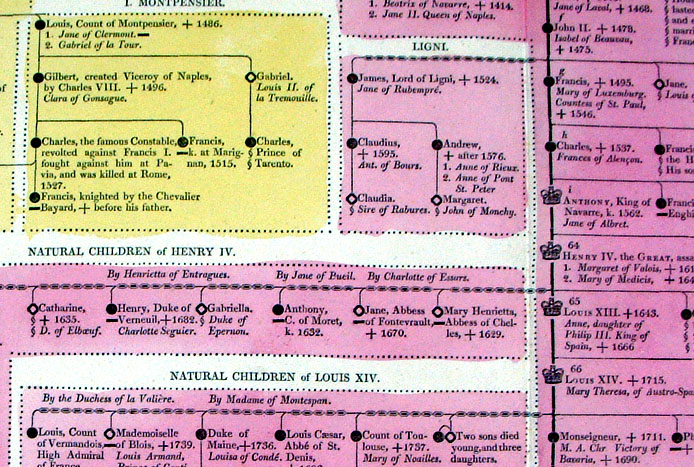
Genealogical, Historical and Chronological Map of France, from Capet, 987, to Henry IV, 1589. From Lavoisne's Genealogical, Historical, Chronological and Geographical Atlas 1827 - Title Page Hand coloured at time of publication. Page size: 530 x 420 mm, centre fold. Ref LHM043 £24.00 (+P&P) Detail Key to Symbols in Chart click image for enlargement |
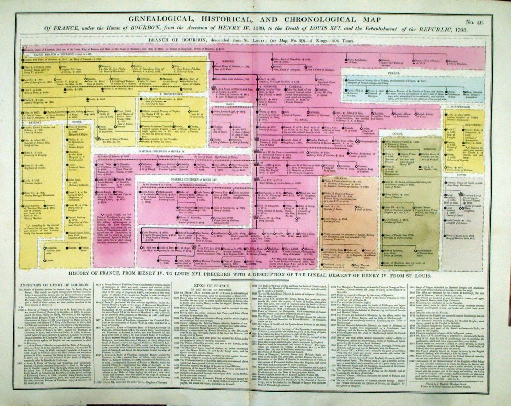 |
Genealogical, Historical and Chronological Map of France, under the House of Bourbon, 1589, to the Death of Louis XVI, 1793 From Lavoisne's Genealogical, Historical, Chronological and Geographical Atlas 1827 - Title Page Hand coloured at time of publication. Page size: 530 x 420 mm, centre fold. Ref LHM044 £24.00 (+P&P) Detail Key to Symbols in Chart click image for enlargement |
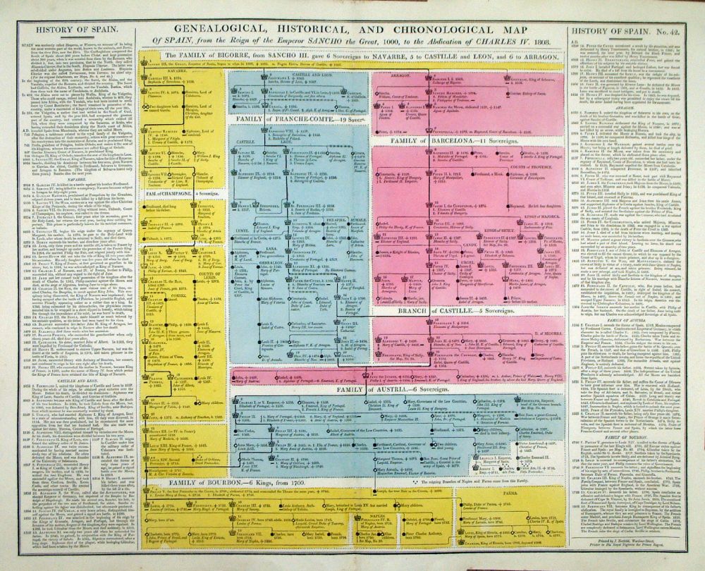 |
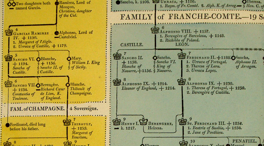
Genealogical, Historical and Chronological Map of Spain from the Reign of Emperor Sancho the Great, 1000, to 1808 From Lavoisne's Genealogical, Historical, Chronological and Geographical Atlas 1827 - Title Page Hand coloured at time of publication. Page size: 530 x 420 mm, centre fold. Ref LHM046 £24.00 (+P&P) Detail Key to Symbols in Chart click image for enlargement |
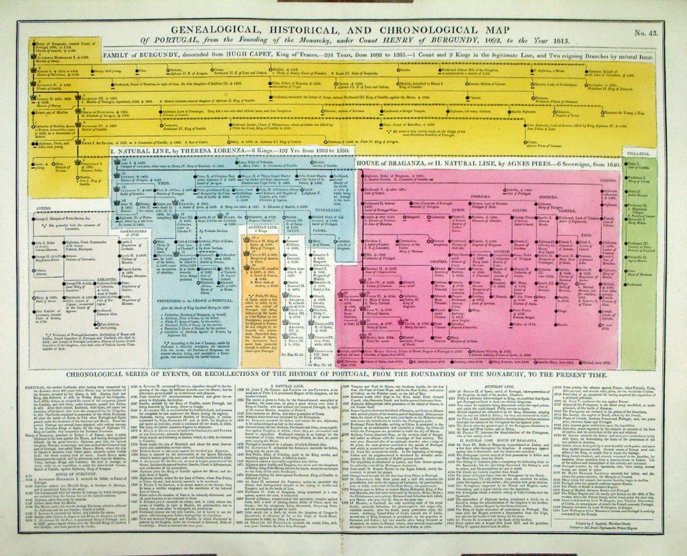 |
Genealogical, Historical and
Chronological Map of Portugal from the Founding of the Monarchy under
Count Henry of Burgundy, 1092, to 1813 From Lavoisne's Genealogical, Historical, Chronological and Geographical Atlas 1827 - Title Page Hand coloured at time of publication. Page size: 530 x 420 mm, centre fold. Ref LHM047 £24.00 (+P&P) Detail Key to Symbols in Chart click image for enlargement |
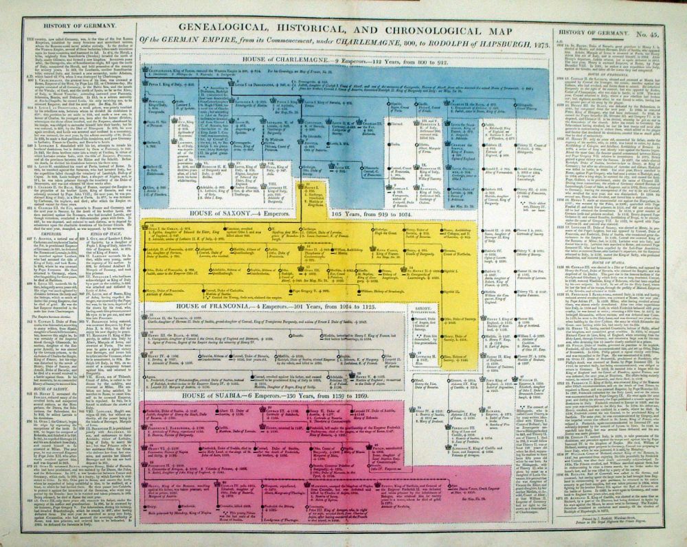 |
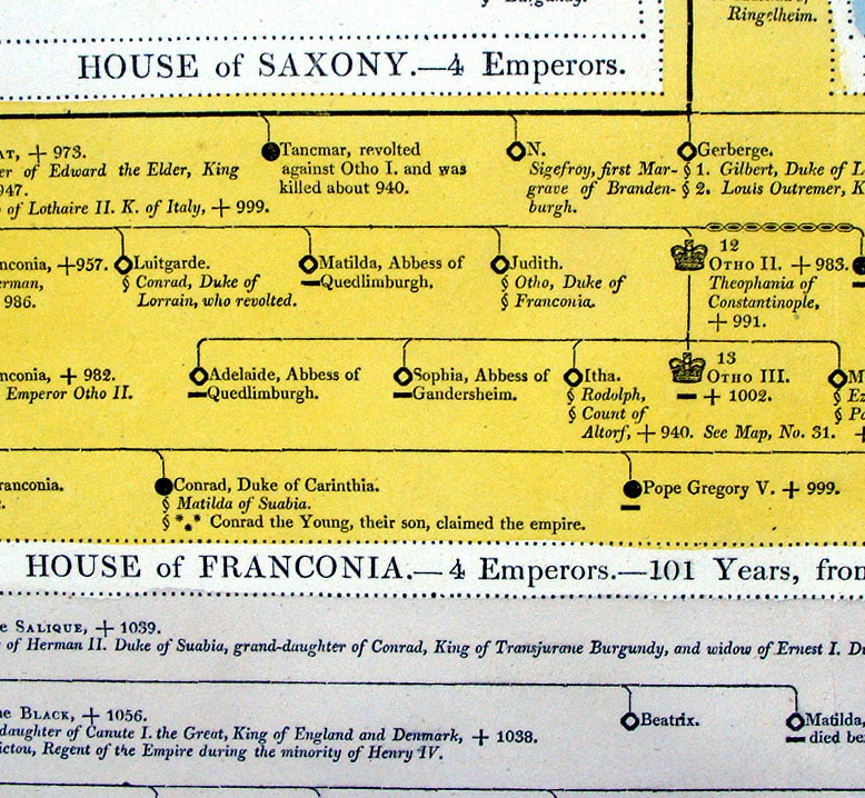
Genealogical, Historical and Chronological Map of the German Empire, under Charlemagne, 800, to 1273 From Lavoisne's Genealogical, Historical, Chronological and Geographical Atlas 1827 - Title Page Hand coloured at time of publication. Page size: 530 x 420 mm, centre fold. Ref LHM049 £24.00 (+P&P) Detail Key to Symbols in Chart click image for enlargement |
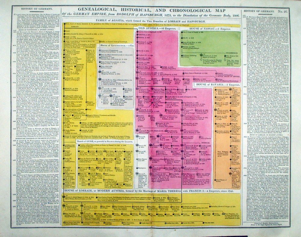 |
Genealogical, Historical and Chronological Map of the German Empire, from Rudolph of Haspburgh, 1273, to 1806 From Lavoisne's Genealogical, Historical, Chronological and Geographical Atlas 1827 - Title Page Hand coloured at time of publication. Page size: 530 x 420 mm, centre fold. Ref LHM050 £24.00 (+P&P) Detail 1 Detail 2 Key to Symbols in Chart click image for enlargement |
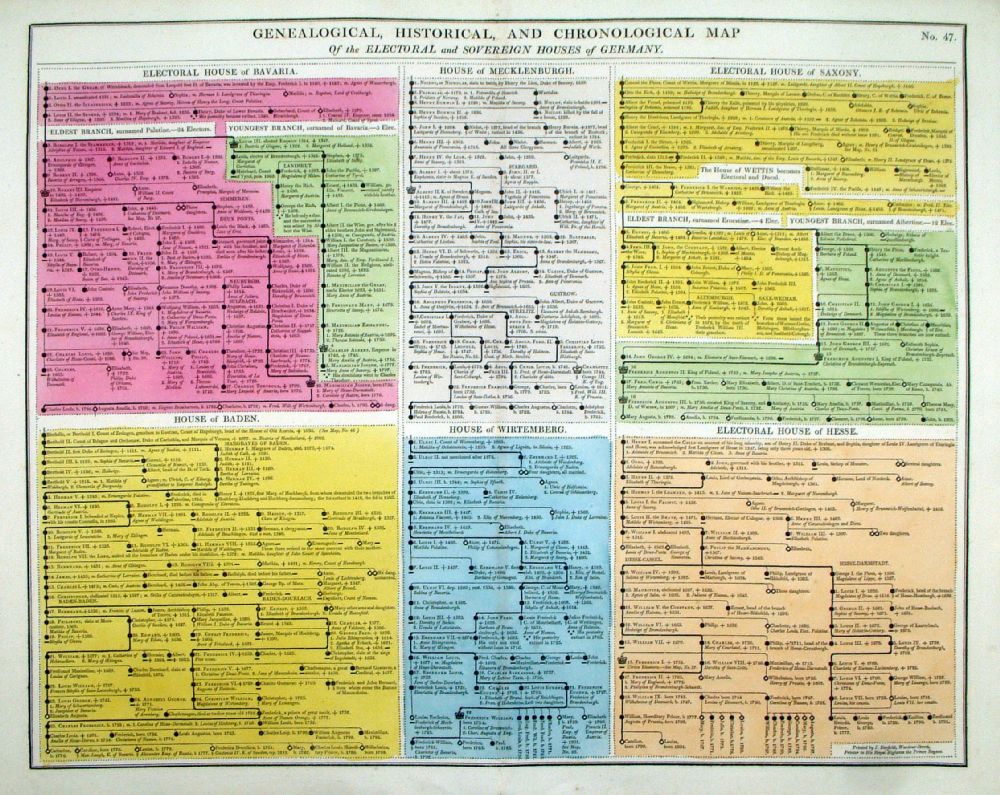 |
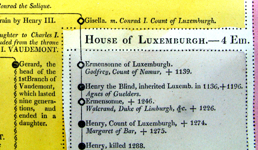
Genealogical, Historical and Chronological Map of the Electoral and Sovereign Houses of Germany. From Lavoisne's Genealogical, Historical, Chronological and Geographical Atlas 1827 - Title Page Hand coloured at time of publication. Page size: 530 x 420 mm, centre fold. Ref LHM051 £24.00 (+P&P) Detail Key to Symbols in Chart click image for enlargement |
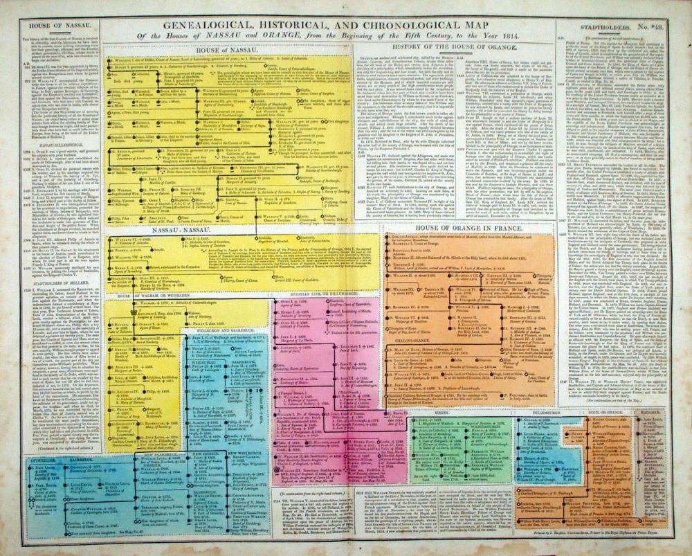 |
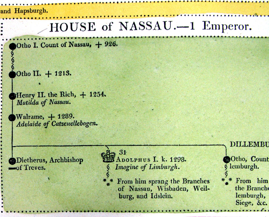
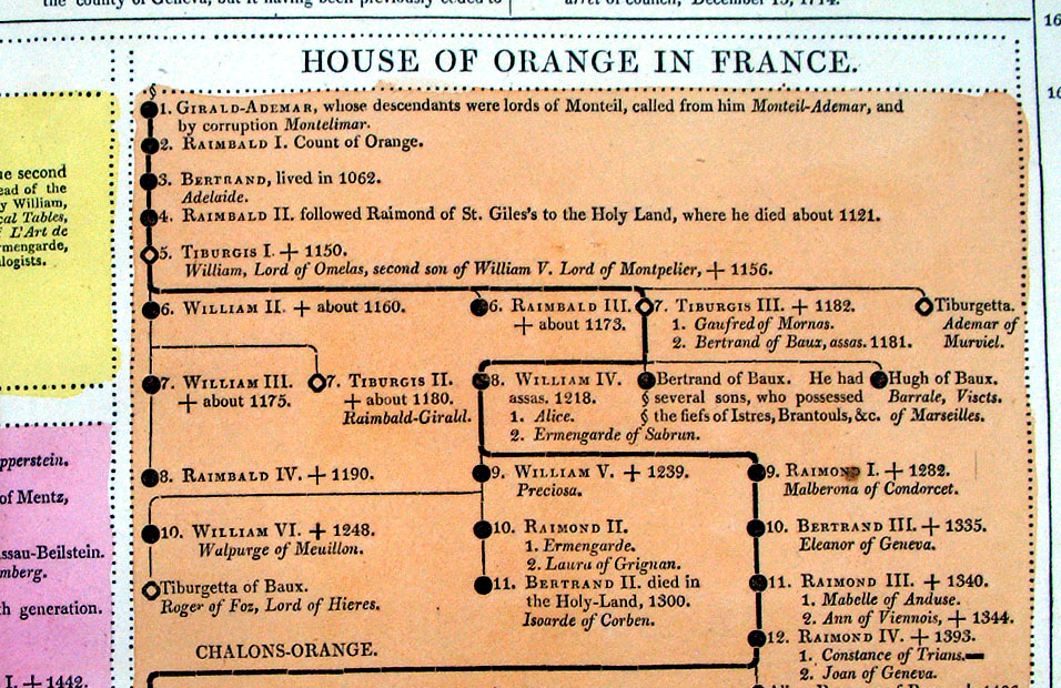
Genealogical, Historical and Chronological Map of the Houses of Nassau and Orange from the beginning of the 5th Century to 1814. From Lavoisne's Genealogical, Historical, Chronological and Geographical Atlas 1827 - Title Page Hand coloured at time of publication. Page size: 530 x 420 mm, centre fold. Ref LHM053 £24.00 (+P&P) Detail Key to Symbols in Chart click image for enlargement |
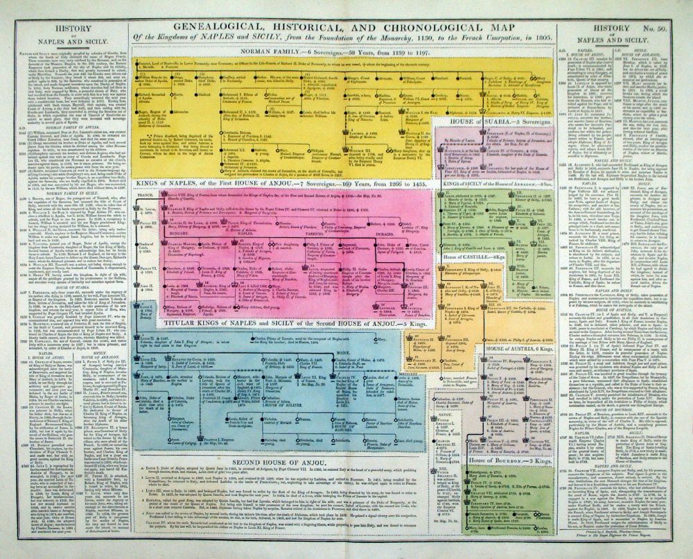 |
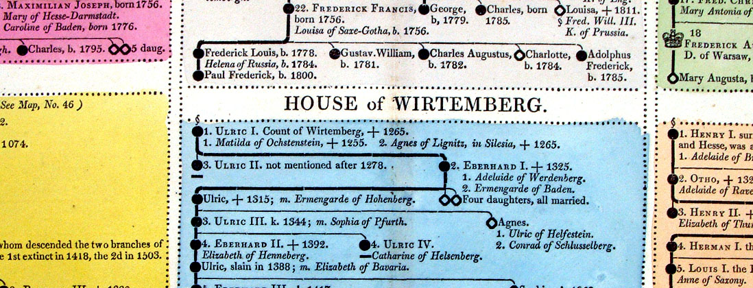
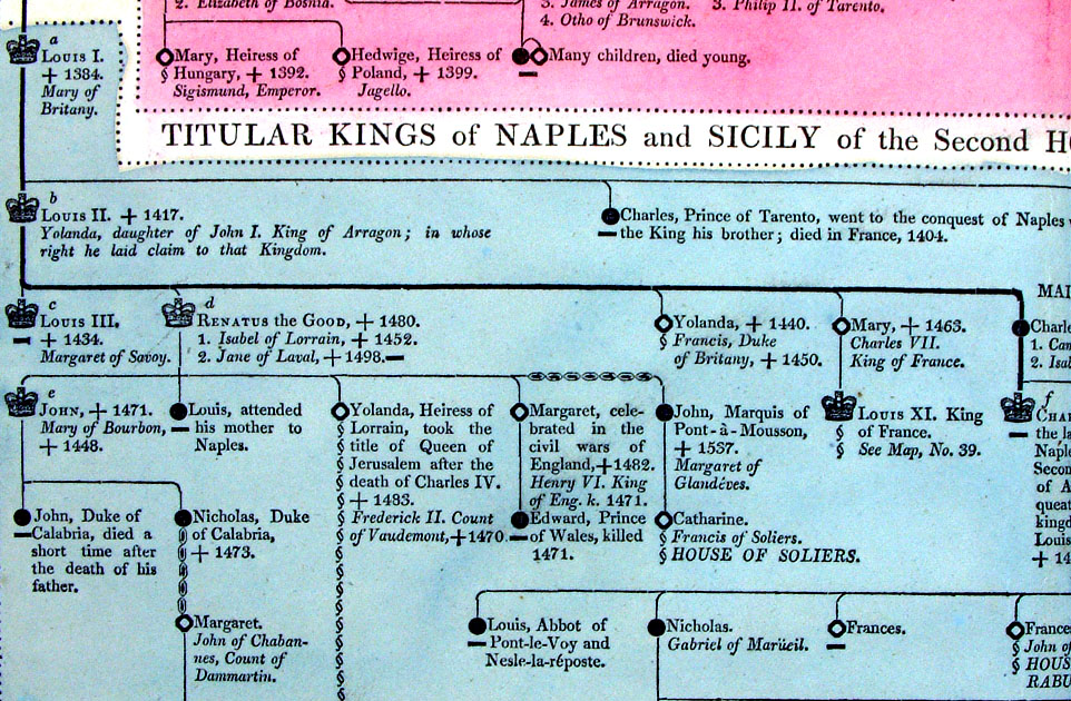
Genealogical, Historical and Chronological Map of the Kingdoms of Naples and Sicily from 1130 to 1805 From Lavoisne's Genealogical, Historical, Chronological and Geographical Atlas 1827 - Title Page Hand coloured at time of publication. Page size: 530 x 420 mm, centre fold. Ref LHM055 £24.00 (+P&P) Detail Key to Symbols in Chart click image for enlargement |
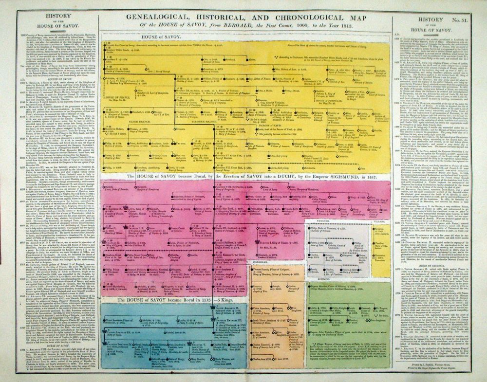 |
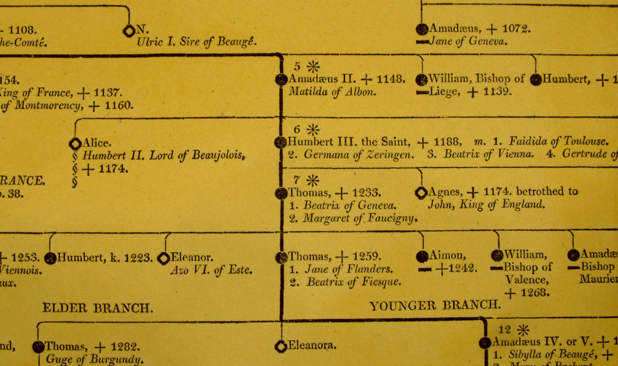
Genealogical, Historical and Chronological Map of the House of Savoy, from Beroald, 1000, to the year 1813 From Lavoisne's Genealogical, Historical, Chronological and Geographical Atlas 1827 - Title Page Hand coloured at time of publication. Page size: 530 x 420 mm, centre fold. Ref LHM056 £24.00 (+P&P) Detail Key to Symbols in Chart click image for enlargement |
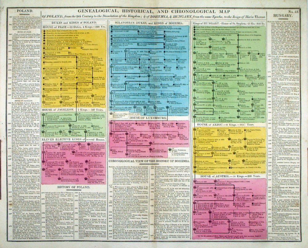 |
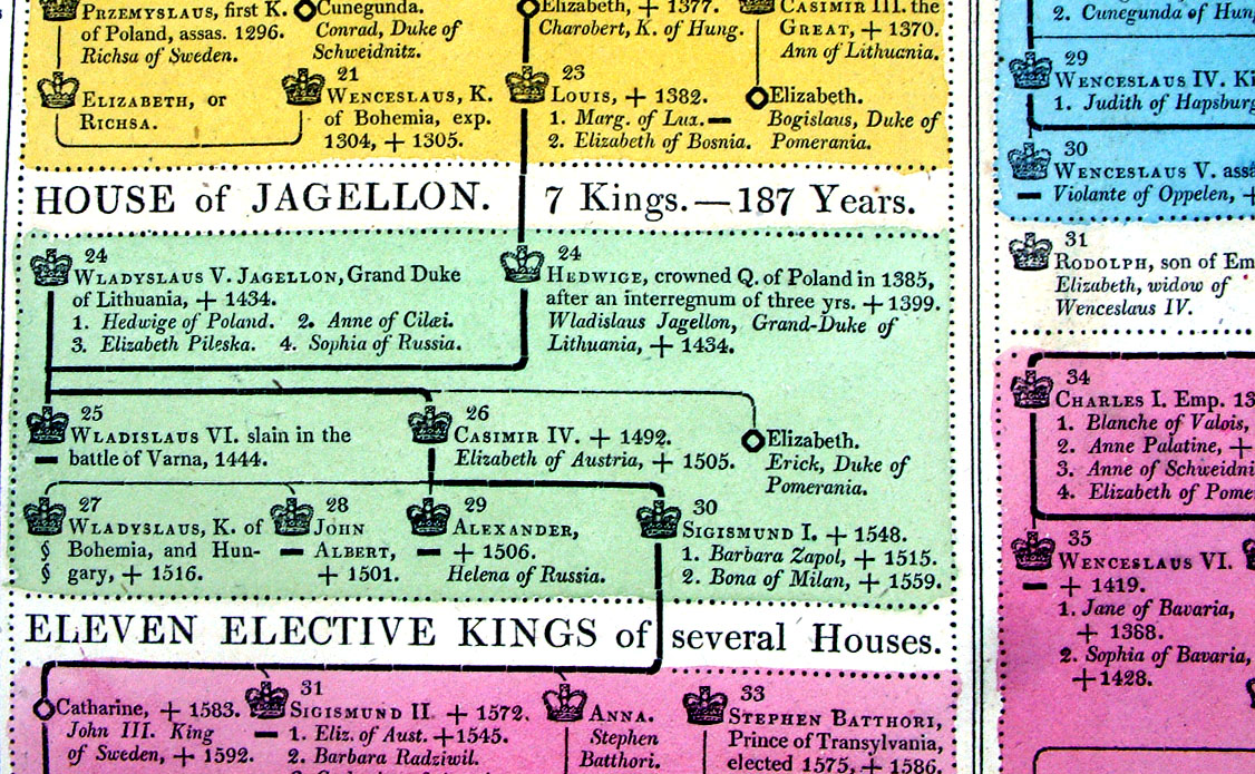
Genealogical, Historical and Chronological Map of Poland from the 9th Century: and of Bohemia and Hungary From Lavoisne's Genealogical, Historical, Chronological and Geographical Atlas 1827 - Title Page Hand coloured at time of publication. Page size: 530 x 420 mm, centre fold. Ref LHM058 £24.00 (+P&P) Detail Key to Symbols in Chart click image for enlargement |
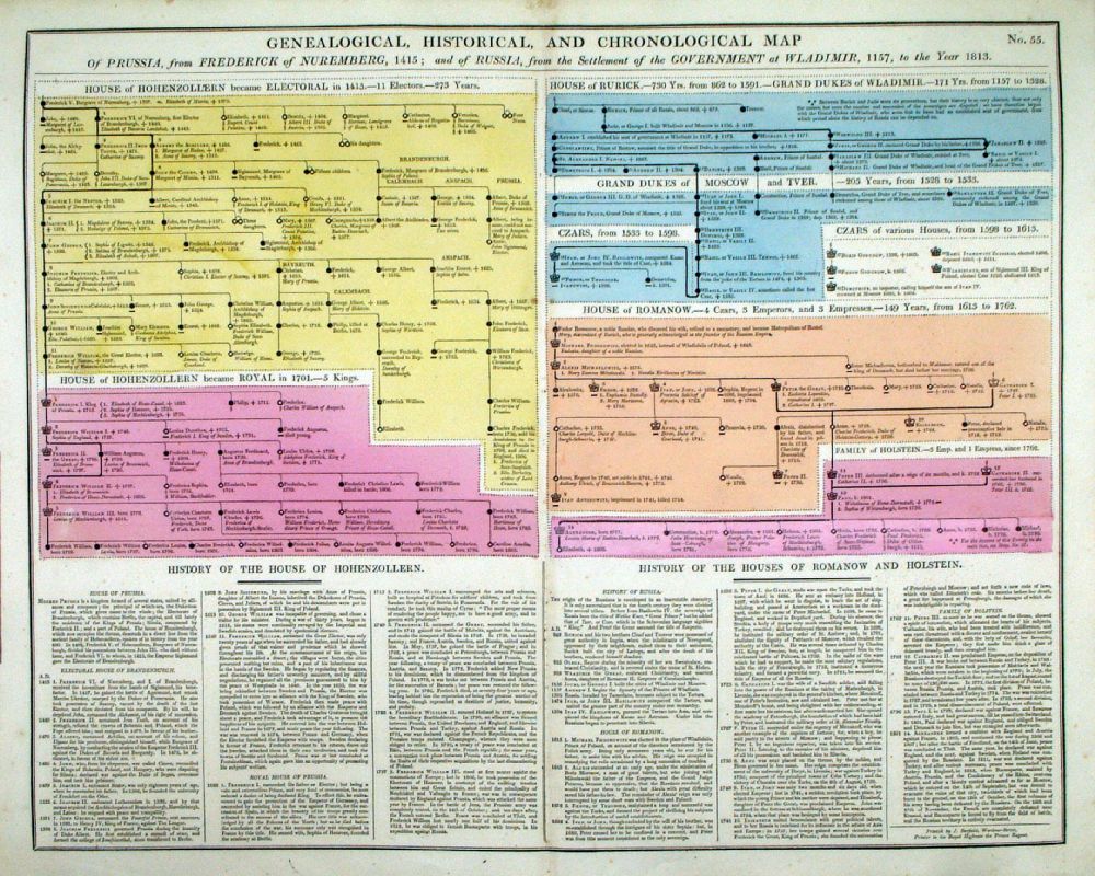 |
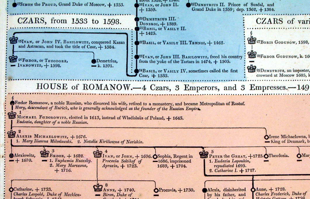
Genealogical, Historical and Chronological Map of Prussia from 1415; and of Russia from 1157 to the year 1813 From Lavoisne's Genealogical, Historical, Chronological and Geographical Atlas 1827 - Title Page Hand coloured at time of publication. Page size: 530 x 420 mm, centre fold. Ref LHM060 £24.00 (+P&P) Detail Key to Symbols in Chart click image for enlargement |
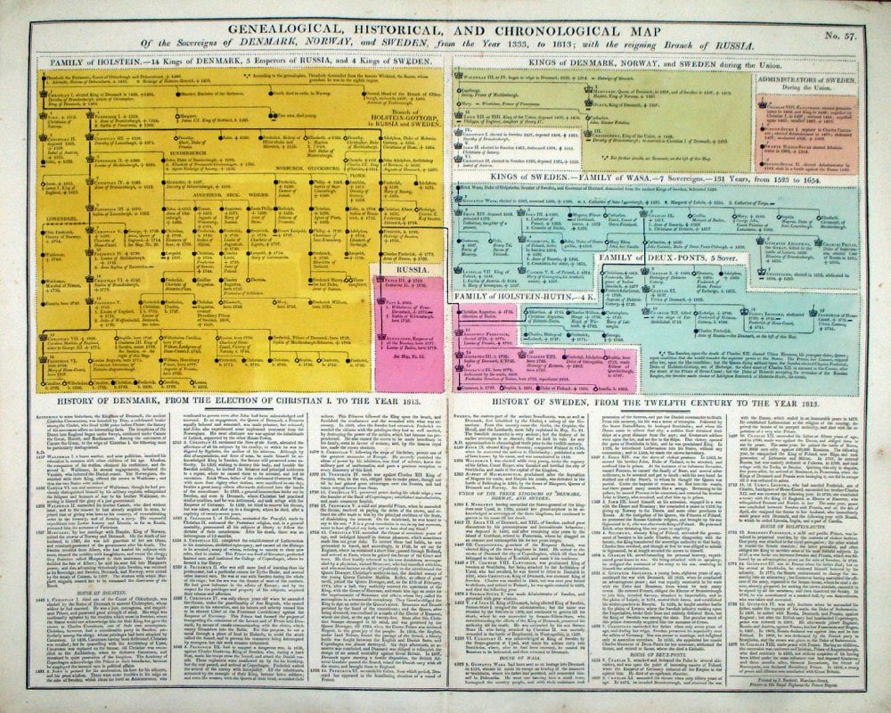 |
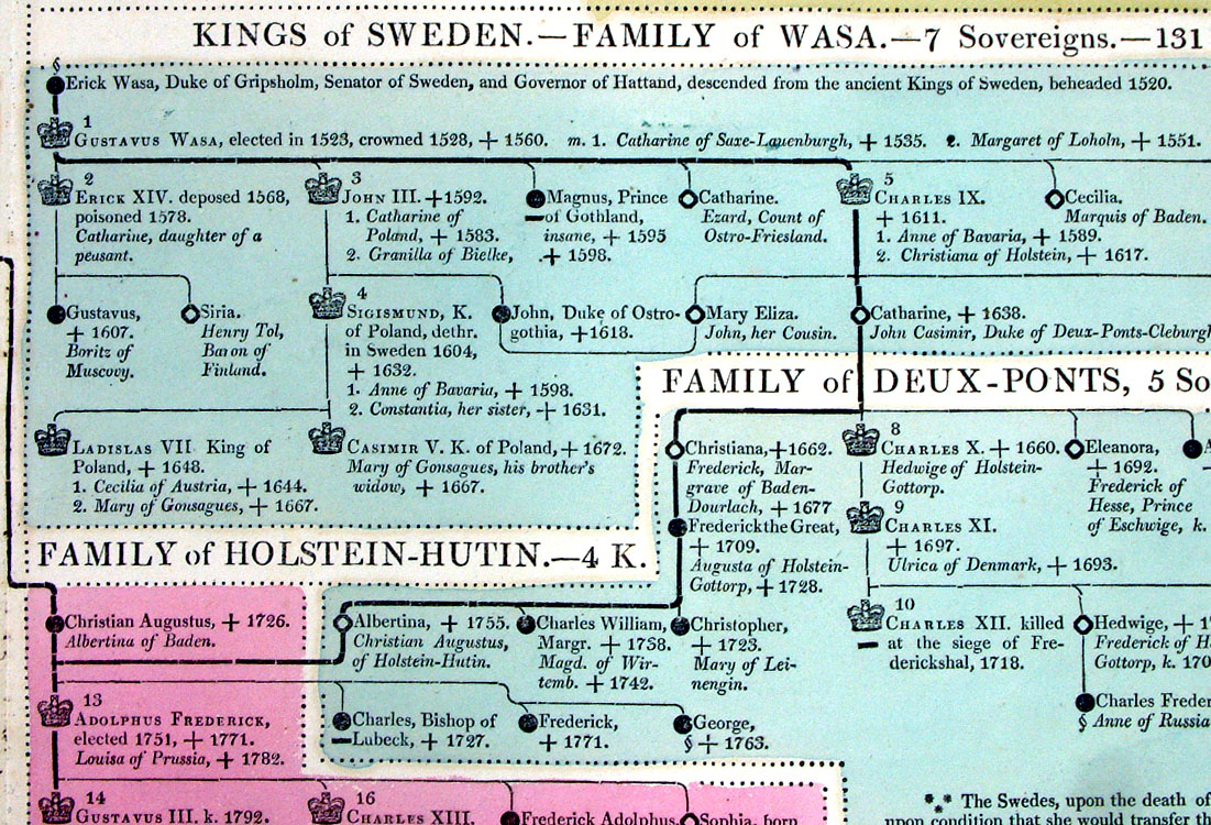
Genealogical, Historical and Chronological Map of the Sovereigns of Denmark, Norway and Sweden from 1333 to 1803 From Lavoisne's Genealogical, Historical, Chronological and Geographical Atlas 1827 - Title Page Hand coloured at time of publication. Page size: 530 x 420 mm, centre fold. Ref LHM062 £24.00 (+P&P) Detail Key to Symbols in Chart click image for enlargement |
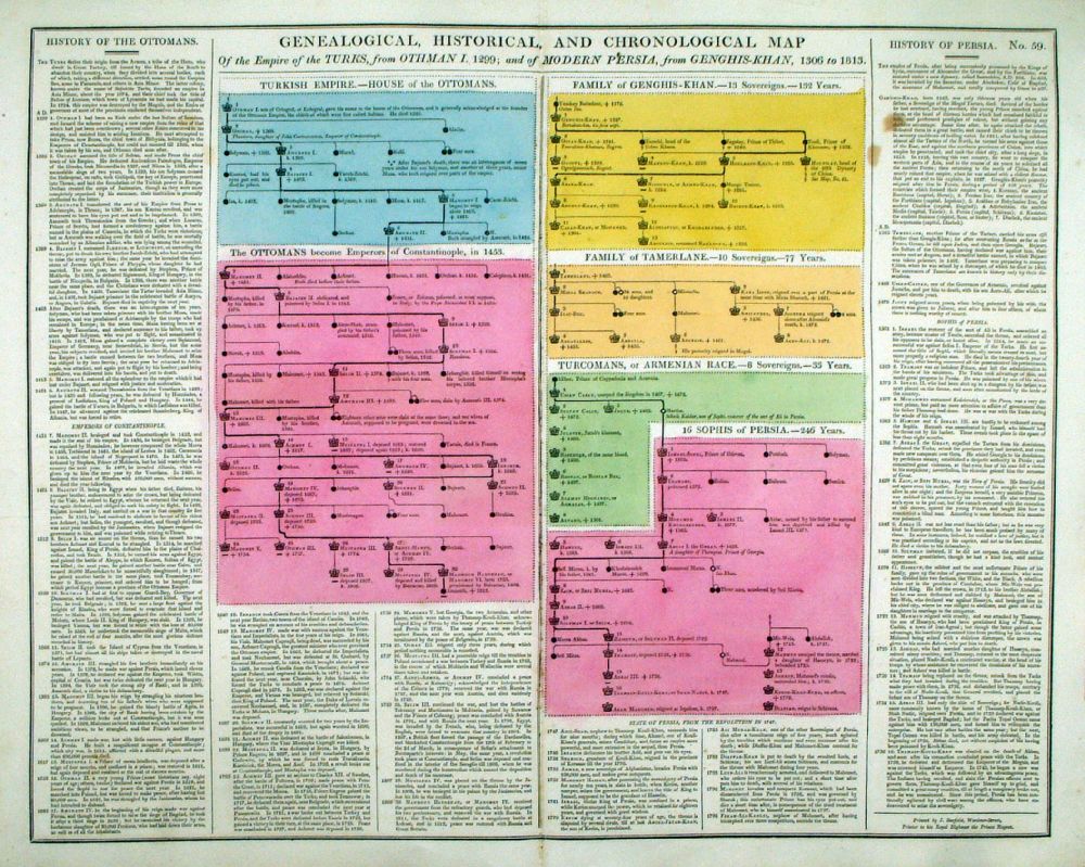 |
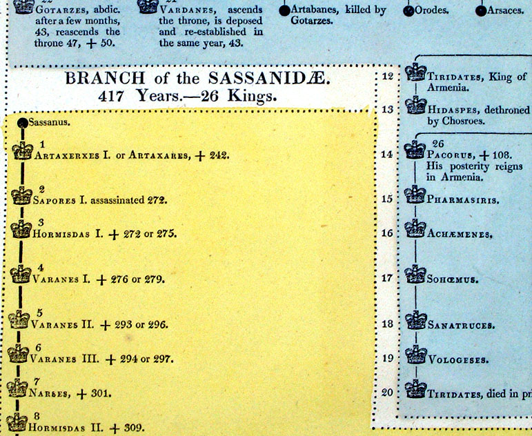
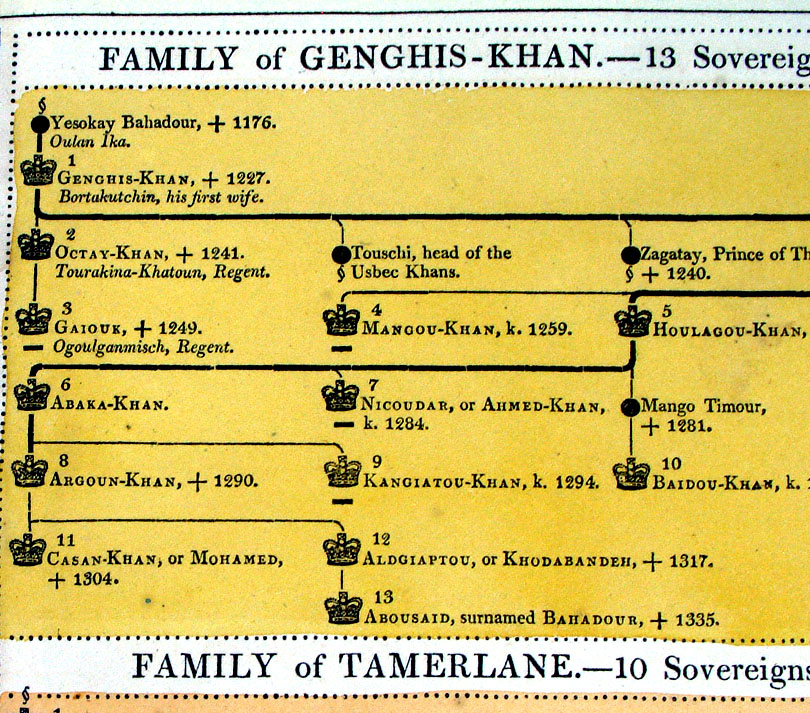
Genealogical, Historical and
Chronological Map of the Empire of the Turks, 1299; and of Modern Persia
from Genghis Khan 1306, to 1813. From Lavoisne's Genealogical, Historical, Chronological and Geographical Atlas 1827 - Title Page Hand coloured at time of publication. Page size: 530 x 420 mm, centre fold. Ref LHM064 £24.00 (+P&P) Detail Key to Symbols in Chart click image for enlargement |
| Discounts available for multiple purchases of tables from Lavoisne's Genealogical, Historical, Chronological and Geographical Atlas 1827 |
|
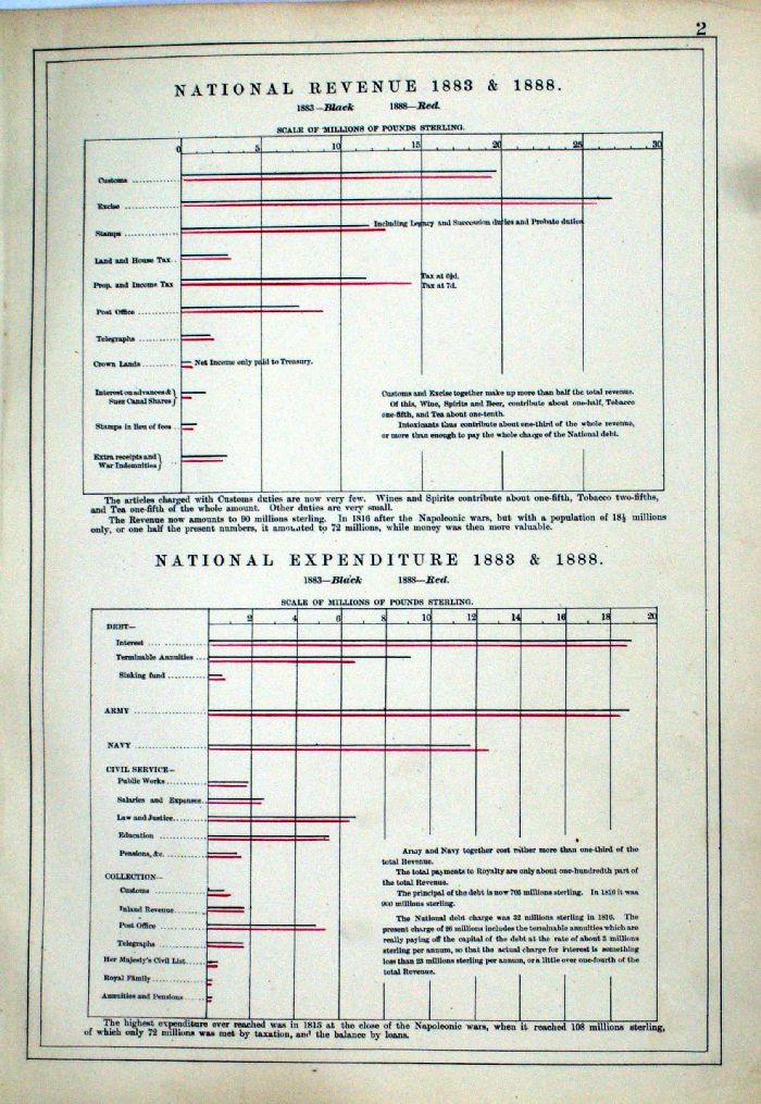 |
National Revenue 1883 & 1888 National Expenditure 1883 & 1888 From the New Large Scale Atlas of the British Isles by G.W. Bacon 1892 size: 240 x 330 mm Ref LHP002 £18.00 (+P&P) click image for enlargement |
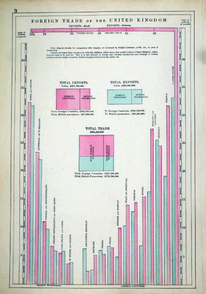 |
Foreign Trade of the United Kingdom Imports - Red; Exports - Green Interesting example of the Y axis rotating through 90 degrees. From the New Large Scale Atlas of the British Isles by G.W. Bacon 1892 Page size: 240 x 330 mm Ref LHP003 £18.00 (+P&P) click image for enlargement |
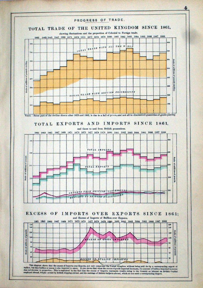 |
Progress of Trade Total Trade of the United Kingdom Since 1861 Total Exports and Imports Since 1861 Excess of Imports over Exports since 1861, and Excess of Imports of Bullion Over Exports. From the New Large Scale Atlas of the British Isles by G.W. Bacon 1892 Page size: 240 x 330 mm Ref LHP004 £18.00 (+P&P) click image for enlargement |
| LHP001 to LHP004 £45.00 for all 4 charts. |
|
| All Genuine Antiquarian Prints - No Reproductions or Modern Copies |
mc MC