Pembury History

Localities - Possible Windmills  in Pembury
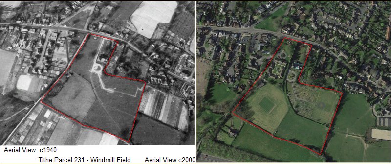
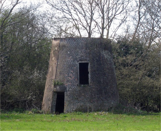
In August 2023 we were contacted by Rob Cumming, an author of books on windmills. He came with some evidence of there being a windmill in Lower Green around 1831.
What we have listed below is the 1831 advertisement, a lot of circumstantial evidence, and some speculative guesswork.
Currently there is no positive identification of the location of this windmill.

Before venturing forth with any additional sluething or investigation please consider these suggestions -

The location suggests 'adjoining good Turnpike road'.  It would be preferable to consider 'adjoining'  as 'close by' rather than literally 'attached to'.
The sale suggests 3 acres of land adjoining the mill.  This may not be 3 acres where the land plots are all immediate neighbours.

Recent speculation dismisses some possible sites in favour of others because of preferential landscape location on higher ground or hill profiles.
At any time in recent history all the countryside was owned and managed. The siters of windmills may not have had the luxury of choosing their ideal spot. 
They were not in a position to wander the countryside, spot a piece of open hillside and gleefully announce "We'll put it there".
It's a fallacy for today's observers to look for such ideal sites in the landscape as contenders for results in our kind of investigations.
As in the 21st Century you can only buy, rent or use land that is available to you at the time.


A Windmill in Pembury


Below is a copy of the advertisement for the sale of the windmill that appeared in Kent newspapers, 3 times over 5 months.  Not a quick sale.
Below the advertisement are Rob Cumming's comments.


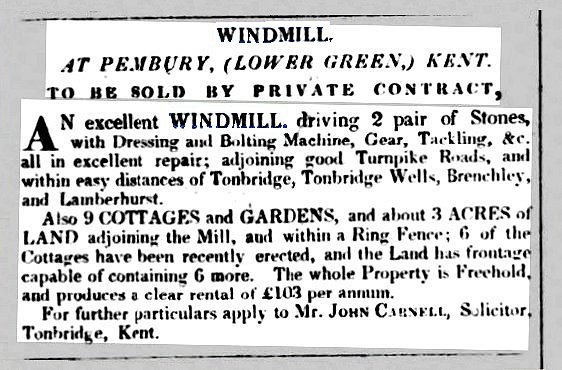
Maidstone Journal and Kentish Advertiser - Tues 26 April 1831
South Eastern Gazette -  Tues 30 May 1831
Maidstone Journal and Kentish Advertiser - Tues  2 August 1831


Hi Tony

Congratulations on the excellent Pembury History site which I've only just found.

I've just had a scan of the mills section, as I've written the odd book on Kent Windmills.  I'm trying to do Kent in sections as the much lauded book by William Coles-Finch, written in 1933 missed so much in terms of mills and information.  I wrote this lot on the watermills about 30 years ago, and haven't really touched it since:

"PEMBURY, Spring Grove Mill. TQ632431.  Tributary of R. Medway.  Traces only.  Spring Grove Mill was a corn mill which ceased operating under Edwin Coppard around 1880, but it probably survived into this century as there are local reminiscences of it.  It had been demolished by 1939 however; today only the impressive mill pond, mill house and fall for an overshot wheel, together with some foundations remain.

PEMBURY, Herrings Mill. TQ644424.  Tributary of R. Medway. Site only. This site was probably only established as a mill in the first half of the nineteenth century; it ceased work between 1862 and 1868 and remained derelict perhaps into this century as it is remembered by an elderly resident.   Water extraction probably ended the mills working life, and the miller may well have received compensation.  The site is now woodland and forms part of a sewage works."

The windmill bit interests me though.  I can say I have no reference to a mill at Windmill Field.

I do however have a number of newspaper references to a windmill at Lower Green.  I suspect its presence was very brief, and it was probably built after the 1819 OS map survey, and gone before the 1840 tithe map.  Various newspaper adverts advertise it for sale in 1831.  I suspect the owner/builder became more interested in building houses at Lower Green than a fairly new working windmill, and I strongly suspect the mill was sold for removal, probably to another parish locally, presumably the land being more valuable for building.  The practice of moving windmills was very common in the nineteenth century, much like moving a business.

Anyway, attached a couple of newspaper references.  I suspect that the site of it was on the plots marked 220 and 309, where it was replaced by housing.

Hope this helps, and happy for you to put it up, and/or share with the people researching this subject.


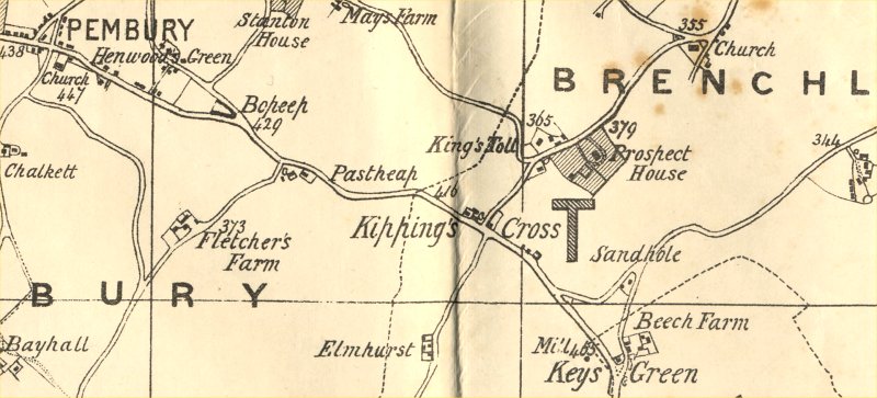
Plot 309 is in Cornford Lane near Mouseden farm and does not relate to Lower Green.
Plot 220 is Brickhurst Field to the south-west of Brickhurst Farm, remote from Turnpike Roads and Lower Green.


Below are copies of the Lower Green portions of the 1840 Tithe map
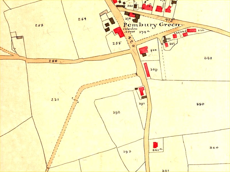
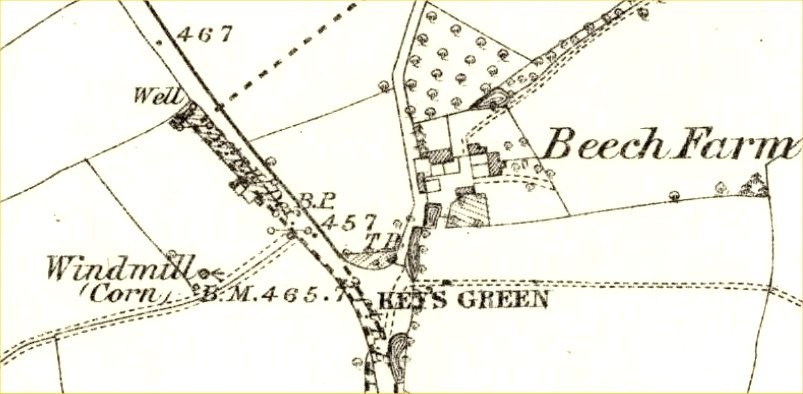
This survey would have been conducted around 1838, some 7 years after the advertisement for sale.


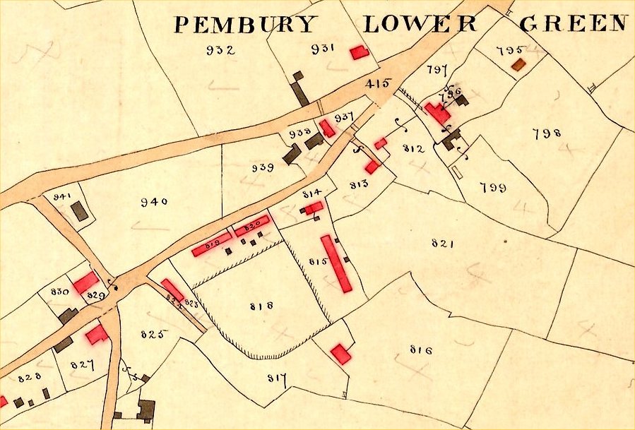
Above:  Southern / Western part of Lower Green at Romford Road and Beagleswood.
The area '415' is the junction of Lower Green Road and Henwood Green Road.
The double lines across the roads indicate the toll gates for paying road taxes.
Both roads needed gates to avoid a cheating detour via Romford Road.
To help assess the size of 3 acres here are some of the plot sizes on the above map.
Plot 821 - 2 acres      Plot 940 -  1 acre       Plot 798 - 1 acre      Plot 818 - 0.8 Acre     Plot 825 - 0.5 Acre     Plot 819/820  - 0.3 Acre
Plot 818 is shown fenced or protected, maybe raised, and is the only contender on the Tithe map for  "... within a Ring Fence". 

For reference purposes plots 819 & 820 (12 houses) were known as Slate Row.    815 (10 houses) was known as Red Row.
Plot 813 is occupied by Waterfield House Surgery.  The building 823 is 3 dwellings.
Red buildings are inhabited.   Black or grey buildings are unihabited (churches, barns, sheds, stables, etc).


Below :  Northern /  Eastern part of Lower Green at Church Road


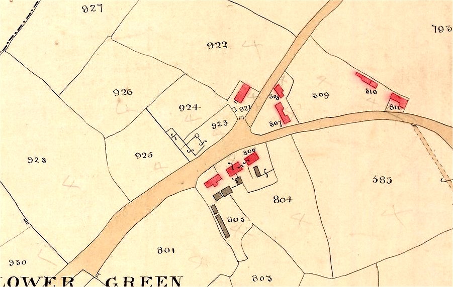
The 1831 sale of 3 acres does not specify that it is one plot or that any multiple plots totaling 3 acres are adjoining neighbours.
Buildings shown in red are habitable.  Buildings shown in grey or black are unihabitable (sheds, churches, workshops, barns, etc)
Plot 801 - 2 acres       Plot 926 - 1 acre       Plot 922 - 2 acres


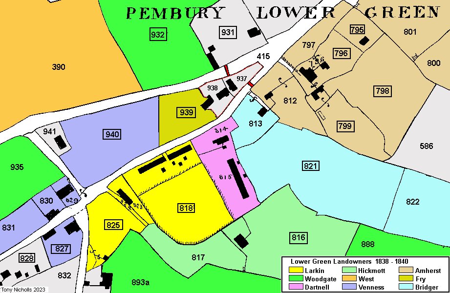
The map above gives an indication of the landowners of plots c1838 - 1840.
If the windmill plot(s) was sold sometime after 1831 clues to its ownership might be taken from the 1838 landowners.
If the windmill plots were NOT sold the owner may have demolished the windmill for better use of the land.
If the windmill plots were sold but the windmill was NOT needed it may have been demolished.
We cannot tell from the available data if the 1831 sale was successful.


Plots 937 and 938 were owned by The Road Trusts.    937 was the gate house for collecting road taxes.  Toll gates shown in red.


The following data has been gathered by Jane Grooms.
This is a result of searches for Pembury Debts, Deaths, Sales and Purchases in the years around 1831.
It is hoped that something may spark a useful line of investigation into this windmill.


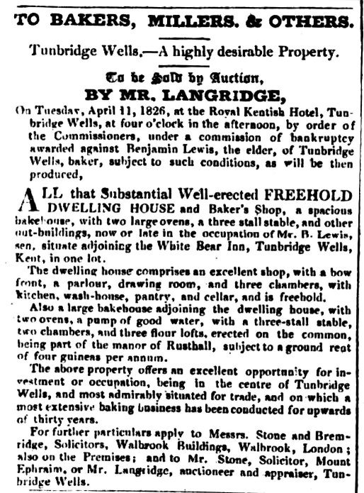
Brighton Gazette    6 April  1826


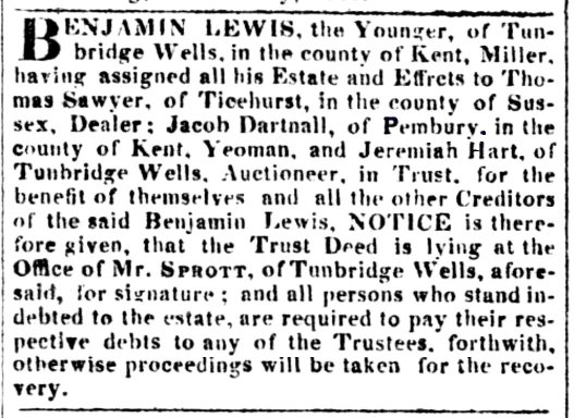
Sussex Advertiser   16 Jan 1826


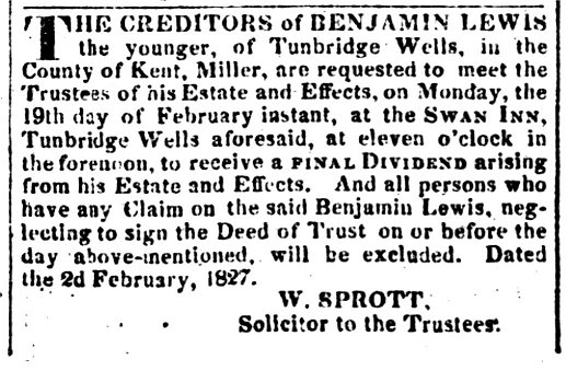
Sussex Advetiser  5 Feb 1827


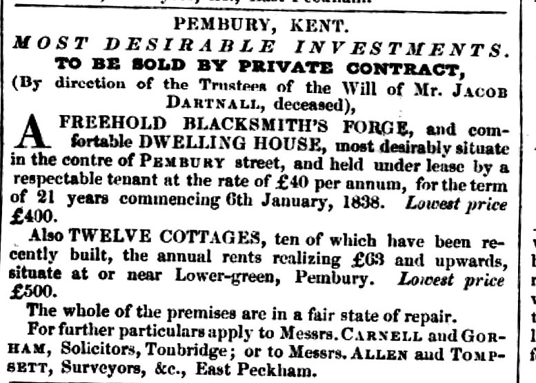
Maidstone Gazette    19 April 1842


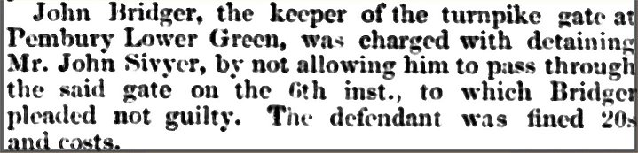
Maidstone Journal and Kentish Advertiser  3 Oct 1843


Jane Grooms has added this speculation -

Observation of articles referring to Benjamin Lewis, miller and Jacob Dartnall

In 1826, Benjamin Lewis (the younger) of Tunbridge Wells, miller, transferred his property to trustees including Jacob Dartnall of Pembury (a yeoman) who were also beneficiaries along with other creditors of Benjamin Lewis (the younger).
In the same year, Benjamin Lewis, the elder, who owned a bakery in Tunbridge Wells, became bankrupt. There is a possibility that Benjamin Lewis, the elder, is the father of Benjamin Lewis, the younger, and the two legal proceedings are connected.
In 1827, there is a meeting of creditors to settle the debts of Benjamin Lewis, the younger. The windmill which existed in Pembury, Lower Green, was advertised for sale in 1831 a few years after these events. These articles are interesting  because a Jacob Dartnall owned plots 814 and 815a on the Tithe map as indicated on the Tithe Schedule of 1840. Assuming this is the same Jacob Dartnall who was a trustee and beneficiary of the trust relating to Benjamin Lewis (the
younger) plus also a creditor, was this business connection related to the land in Pembury where the windmill at Lower Green might have been?  The key is the fact that Benjamin was a miller. Jacob Dartnall died in 1842 and reference is made to cottages which seem likely to be those shown on the plots he owned on the Tithe map.

Jane Grooms, August 2023


Jane Grooms has added this further speculation -

What area of land could be the land and property described in the Windmill Article of 1831?
NOTE: ALL PLOTS REFER TO THE TITHE MAP SURVEYED IN 1838 AND PUBLISHED IN 1840.

As spotted by Tony Nicholls, the only contender for an area “within a ring fence” is plot 818.
Plot 818 along with plots 819, 820, 823, 824 and 825 were in the ownership of Thomas Larkin with Thomas Hallett occupying all plots except plot 824, the “Roadway” and plots 818, 825 “Meadows” as described in the Tithe Schedule of 1840. It is my contention that these plots owned by Thomas Larkin in circa 1840 represent the land and property for sale in the Windmill Article of 1831.

If my contention is correct, the Windmill article of 1831 can be explained as follows:

The Windmill Article refers to nine cottages, “adjoining the mill, and within a ring fence; six
of the Cottages have been recently erected.

Plot 823 – three cottages
If six cottages have been “recently erected”, that means three cottages on the land for sale in question are older as “Nine COTTAGES and Gardens” are for sale along with the windmill and land. Plot 823 on the Tithe Map contains three cottages which are older than the two groups of cottages on Plots 819 and 820 on the Tithe Map. As of 2023, these three cottages are known as 138 Henwood Green Road (Henwood Cottage), 140 Henwood Green Road and 142 Henwood Green Road (Damson Cottage). The “Roadway” on Plot 824 still exists in front of the three cottages as of 2023.

The article goes on to state “the land has a frontage capable of containing six more.”

Plots 819 and 820 – six cottages on each plot
It is unknown whether the cottages on plots 819 and 820 were built at the same time but my contention is that one set of six could have been built in about 1831 and the second set after the sale of the property in 1831 which would fit the description in the article. As of 2023, plot 820 still contains six cottages but plot 820 contains six cottages plus more modern houses attached at either side. On the 1841 Census, these twelve cottages are described as “Larkin Row”. Thomas Hallett (occupier) is a Butcher and lives at number 7.

Which Plot could the Windmill have been on?
I think the “Roadway” on Plot 824 and the older three cottages on Plot 823 are significant. On the one hand, the Windmill could have been within the “ring fence” on Plot 818 behind the three cottages on Plot 823. However, if the Windmill Article of 1831 is to be taken literally, the “ring fence” appears to be related to the area of the cottages not the Windmill.
It follows, could the Windmill have been on Plot 825? This plot has the advantage of being next to the Roadway at 824 and is a junction point. As of 2023, Plot 825 is where fast food take away exists on the corner of Romford Road and Henwood Green Road..

In conclusion, the above is my opinion. If research emerges to prove or disprove these contentions, it will be updated accordingly.
                                                                                                Jane Grooms (October 2023)


During the compilation of this page various assumptions and presumptions were expressed about windmills.
Rob Cumming has since been in contact to clarify and correct some of these wayward statements (all removed).
Many thanks to Rob for these later contributions  -

Just to correct you on a couple of things:

    Kent windmills were almost exclusively for corn grinding/flour production.  Out of the 500+ that existed, I think 6 were sawmills, one was used for oil production, a handful for pumping water;  the sales adverts show that this was a corn mill, with the machinery listed in the advert confirming this.

    You really do need to emphasise that the mill was probably sold for removal, and it might be worth speculating as to where, which would be within a ten-mile radius of Pembury.  Windmills were expensive machines, but very moveable.  The mill at Lower Green was relatively new, so very sellable.  Steam power was very much in its infancy and not widely used in mills for another 30-40 years.  Very unlikely the mill was demolished at a loss;  it could I guess have been burned down for its insurance value, but this would have attracted newspaper attention probably.  Most likely to have been sold at a knock down price and moved to a parish nearby.  I have recently proved the move of a windmill at Southborough to Tonbridge in the 1830s, and there are at least 80 recorded windmill moves in the county as it is a surprisingly easy thing to do, for a wooden post mill or smock mill.  The late 1820s and early 1830s were a time of severe depression, and I would suspect that, as with other Kentish mills, the owner struggled to find paying and honourable tenants, and eventually was forced to cut his losses and resort to house-building.

    When looking at maps, I suggested the plots 220 and 309.  I got this as marked on the road from the 1868 OS map, as I didn't have the Tithe map to hand.  This actually corresponds well with other suggestions online that it is in the vicinity of plots 819 and 820 on the Tithe where the cottages were built, so I think we are probably thinking along the same lines on that one.

Regards
            Rob Cumming


Any further developments, corrections or edits will be posted here.            Tony Nicholls  Aug 2023


Notes on Windmill Field  (Hastings Road)

Noted by Kathryn Franklin from the 1840 Tithe Schedule.

Above –  section of the 1840 Tithe Map showing parcel 231 named as Windmill Field in the Tithe Schedule

Below – how Windmill Field fits into the modern landscape – recent aerial photos.


Windmill Field covers St Peter’s Church, The War Memorial, the modern burial ground and the cricket ground.
The field shape can still be recognised from the 1840 map.  Property plots do not change much over the years.
Plot 389 is the Alms House block, and opposite that is the start of “The Old Coach Road”, cutting right across plot 231.
The Old Coach Road is now the access road to St Peter’s Church and the burial ground.
The Old Coach Road came into existence in 1813 when the Marquis of Camden created a direct route to his Bayham Estate near Lamberhurst.
There is no evidence to show that existing paths did not already exist from the Almshouses into Windmill Field then leading south after a sharp bend.

The 1840 Tithe Schedule lists Parcel 231 as  name:  Windmill Field,   acreage: 8-3-38,   owner: Camden,    tenant: Edward Pawley,   use: meadow.

John Ogilby’s road maps of 1676 give great detail on these kind of landmarks. They were vital signs that travelers were on the right road and verification of where they were on the road.  Ogilby’s London to Rye map, passing through Pembury, does not show a windmill. Another old map that could indicate such a structure is Edward Hasted’s map of 1783 from his History of Kent.  This does not show a windmill.  See the ‘Maps’ section of this web site for these maps and others.

Although there is great anticipation that some future discovery will confirm the site of an old windmill here, it is possible that this was just a good vantage point for viewing the windmills at Tunbridge Wells or Kippings Cross.

It is also possible that the windmill existed here long before the 1670s and the field name is all that remains.
There is one element of speculation, and it is pure speculation -
The Tithe Map of 1840 shows the Old Coach Road (established in 1815) running from Hastings Road across Windmill Field and taking a sharp bend toward the far corner.
Perhaps the coach road was following an old established path. Maybe that path was leading to something in the middle of the field.
Bends and kinks in modern roads often have their origins in reaching or avoiding long lost landmarks, buildings or obstacles.

Further comments from Kathryn Franklin refer to estate documents she has seen at Maidstone. Old estate maps (pre-1800) do not show paths or tracks south of Hastings Road in this part of Pembury.  In 1811 Lord Camden persuaded James Skinner Hartridge, owner of Fletcher's Farm, to sell him a narrow strip of land giving him continuous access from Pembury to Dundale Road. An estate map dated 1813 shows the road.
 

Below the windmill at Kippings Cross.      Not strictly Pembury, but included here for local knowledge.


Above:  Pelton map of c1880 showing the windmill just south of Kippings Cross at Keys Green – base still visible from the A21 c2010


Above:  OS map of c1868 showing the windmill (corn) just south of Kippings Cross at Keys Green.


The Keys Green windmill base in recent years


The nearest Tunbridge Wells windmill was the Calverley Windmill close to Windmill Street.


The following links, found by Jane Grooms, gives more general information on the practices of moving, relocating or destroying old windmills.

https://tringlocalhistorymuseum.org.uk/morehistory/Windmills/c_chapter_14.htm

http://www.goudhurstlocalhistorysociety.org/windmills/


Tony Nicholls 2023


Localities - Windmills
                     
Pembury History


IMPORTANT !!!     This needs your help.  All contributions will be credited.  If you have any further information or corrections please contact me –
Tony Nicholls      email:     pemburyhistory@gmail.com