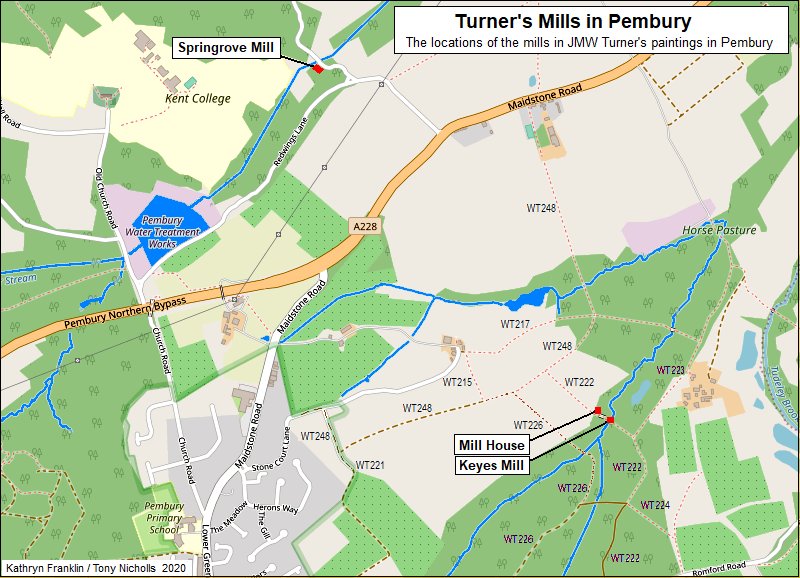
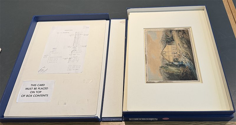
Localities
- Old Mills in Pembury
There have been two working water mills in Pembury,
both of them painted by J.M.W. Turner. This
page is for the local history of the mill sites, not
for any comment The content of this page has been assembled from
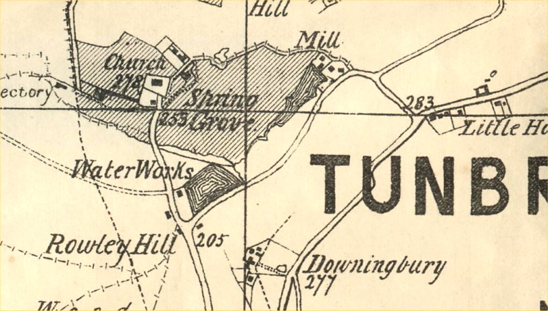
many sources and some information may be duplicated. The map below identifies the location of the mills, followed by various descriptions and references.
Also known as Pembury Mill or Hawkwell Mill Above – Spring Grove Mill at it appears on the 1840
Tithe Map – Note orientation is
North roughly to the right.
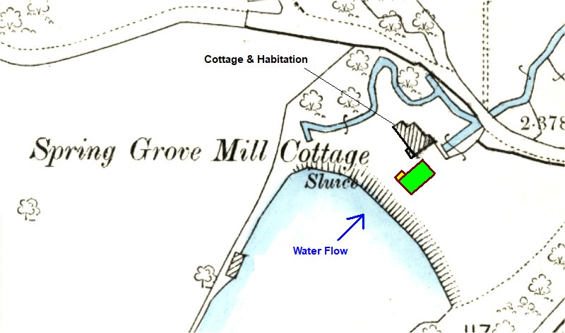
Above: An edited OS map indicating the
locations of the mill building and the mill house
(cottage).
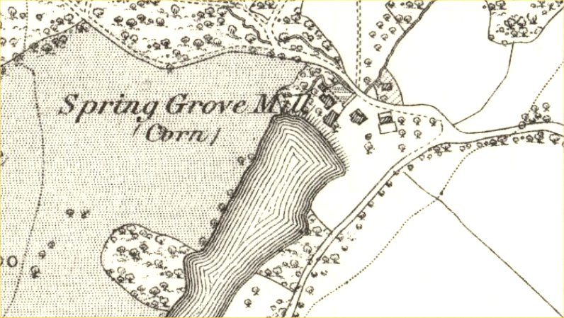
Above: Pelton Map of c1880 showing Spring Grove Mill
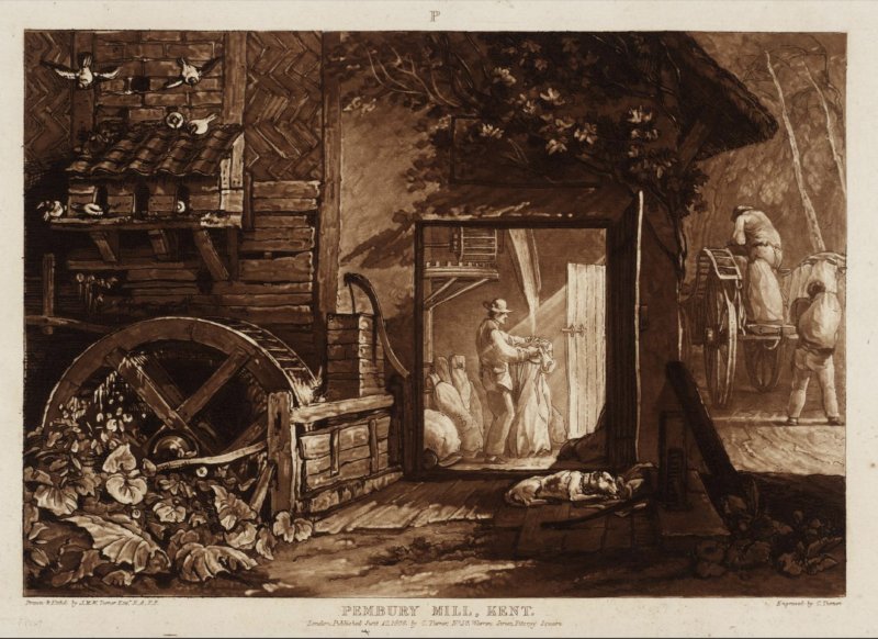
Pembury Mill,
Kent etching 1808
J.M.W Turner Tate, London
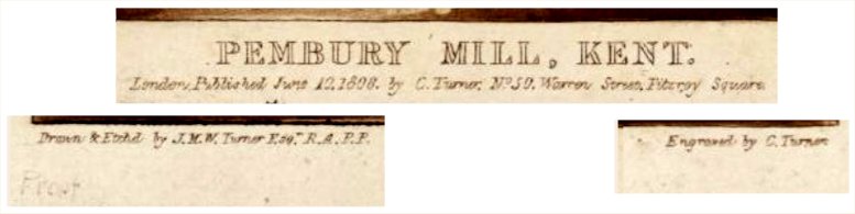 Details of the inscriptions show it was a 'Proof' copy - that is, prior to mass production or general publication. p001a Drawn & Etched by J.M.W. Turner Esq, R.A.P.P. London, Published June 10 1808 by C. Turner No 50 Warren Street, Fitzroy Square Engraved by C. Turner This implies that C.Turner engraved the copper plate and J.M.W Turner oversaw the acid etching process. The Capital P at the top-centre of the print signifies its landscape category as explained by Dr Selby Whittingham - I think P at the top would denote one of the categories of landscape into which the Liber Studiorum prints were divided - in this case P = Pastoral as opposed to EP variously given as Epic or Elegant Pastoral. The drawing shows the
miller inside the mill and the gearing. Outside
there is a water wheel
 p001b These defects in the copper plate can be seen on images p001 & p002 confirming that they were taken from the same copper plate.
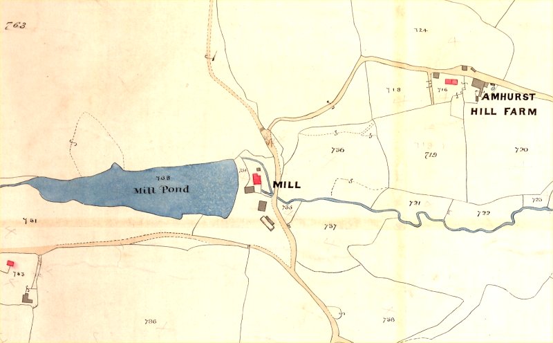
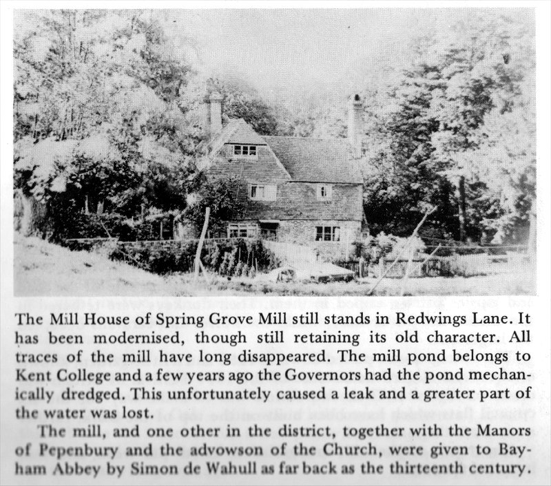
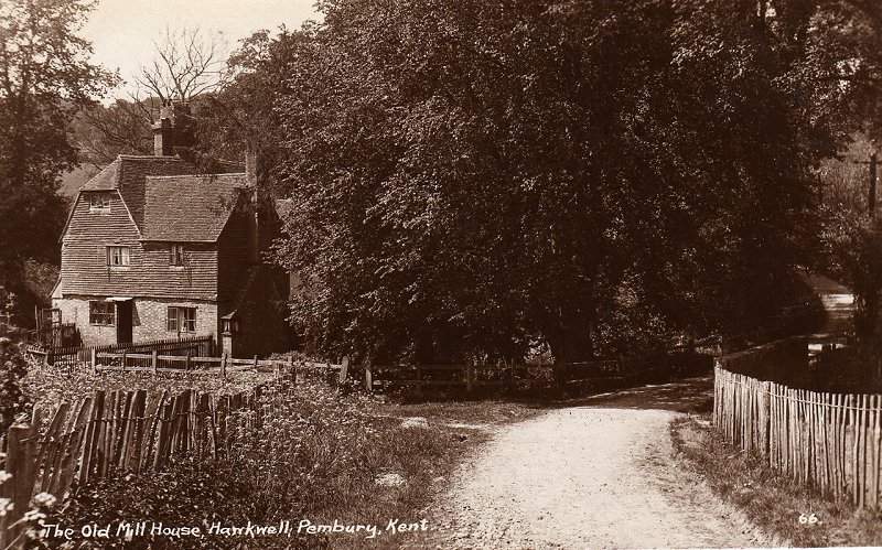 p003 Postcard of Old Mill House, Hawkwell (Amhurst Bank Road, off Redwings Lane)
Extract from Mary
Standen’s Pembury in the Past
1984 (page15)
|
--------------------------------------
Keyes Mill
---------------------------------------
|
The maps below give
varying interpretations of the Keyes Mill (sometimes
Herring's Mill) and they are not consistent.
Do not try and interpret these maps as some kind of
evolutionary progression of development. Maps
lie. They may mislead.
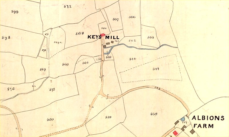
m006
Above – A
section of the 1840 Pembury Tithe Map showing Keyes
Mill and Albans Farm – note unconventional
spellings.
Stephen Sawyer owner of plots 559 to 572 and
579a. John Homewood recorded as the
occupier / tenant.
Note – IMPORTANT – North is roughly to the right, not up.
Below – enlarged section of same map showing Keyes Mill (larger, but no greater detail)
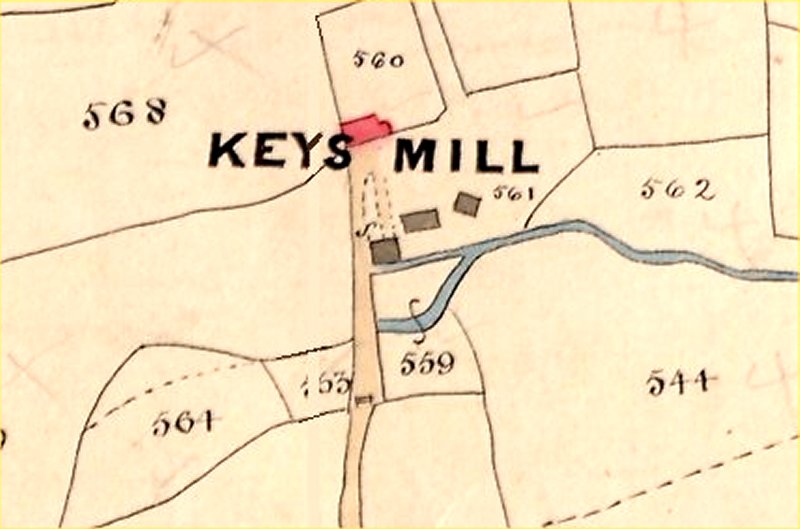
m007
Note the mill access
road is gated between parcels 563 and 559.
Red colouring indicates inhabited buildings.
Grey colouring indicates non-inhabited buildings
such as sheds, barns, and outhouses.
Parcel 560 is indicated on later maps. See
maps below.
Note there is no indication of the feeder stream or
mill pond through parcel 569 (adjacent to 564 &
563).
Note – earlier versions of this page indicated
parcel 563 as 153 – an error due to a fold in the
map when photographed.
m008
Above: Lower & Straker map of 1845 showing Herrings Mill.
m009
Above: Colbran map of 1850 showing Herrings
Mill
 m010
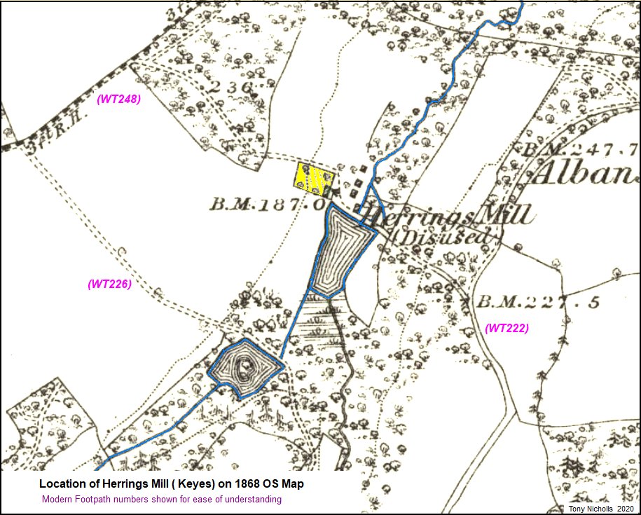
m010
Above – 1868 OS map
showing the disused Herrings Mill.
Colour added to enhance key features.
The yellow enclosure indicates the likely mill house
compound. This is shown as parcel 560 on
the 1840 Tithe map.
Water flow is south to north with the upper pond on
path WT226.
This map does show 4 other buildings/structures in
the centre ground north of the lower mill
pond. Greater clarity lower down this page.
Flow is then to the lower pond (on path WT222)
directly feeding the mill. Turner’s
painting indicates a view uphill looking south.
Although this 1868 map shows the mill disused it is understood that the mill stopped functioning in 1885. See map notes below.
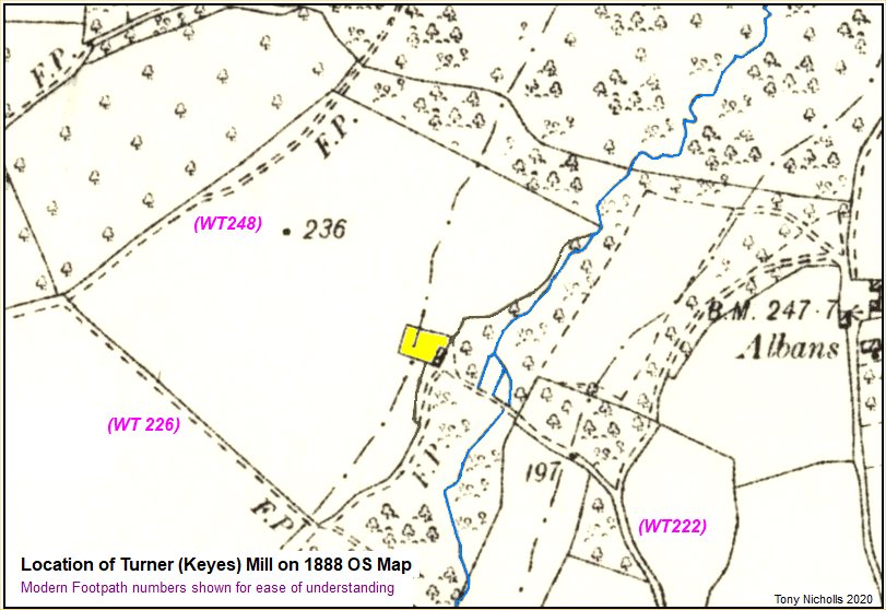
m011
Above – 1888 OS map
showing the disused mill site.
Colour added to enhance key features.
The yellow enclosure indicates the mill house
compound. Note the absence of mill ponds since
1868.
m012
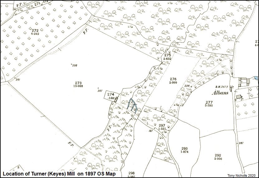
Above – OS map surveyed in 1895, published in 1897 Similar in detail to previous 1888 map.
m013
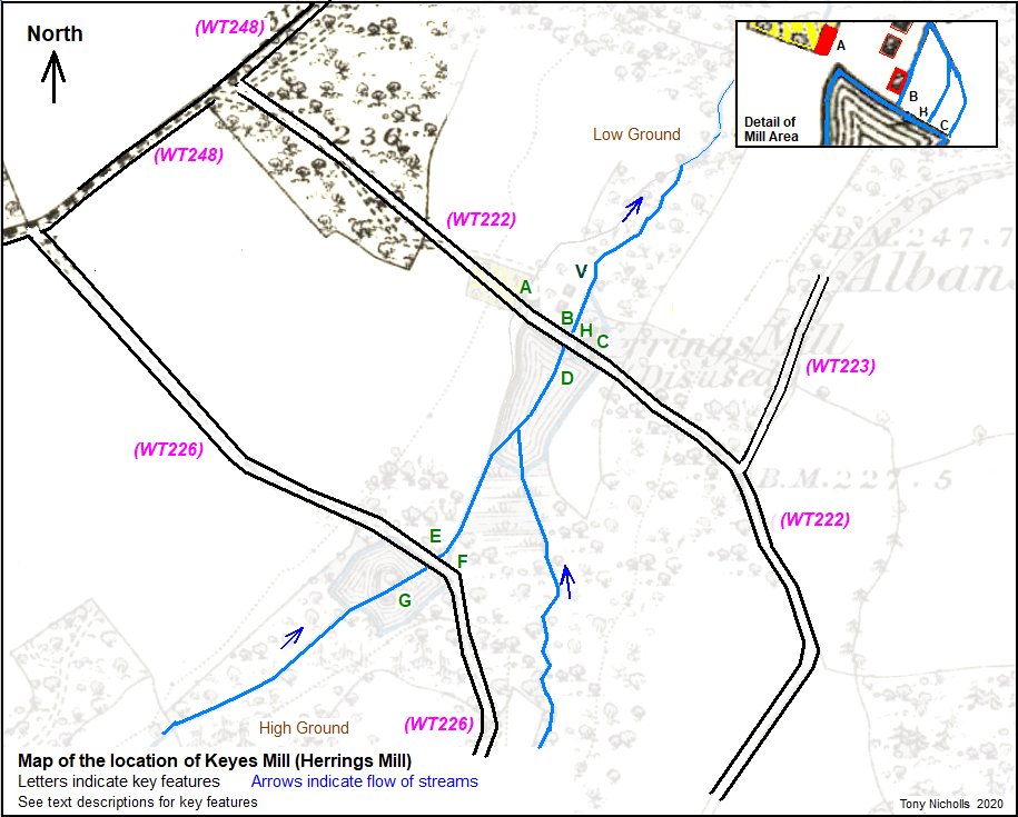
Above – another
variation of the Keyes Mill location map indicating
key features discussed here.
This map includes a detail of the other outbuildings
or structures for greater clarity.
It is also adorned with reference letters to help
identify key features and aid the descriptive text
and photos.
A
– site of the mill house – on the 1868 OS map
and the 1888 OS map shown in yellow enclosure.
B – site of the
water mill
C – site of culvert or
sluice channel and water diverter.
D – site of lower mill
pond
E – footpath Bridge on
WT226
F – location of a
culvert or sluice hole passing under the
footpath/through the dam to the upper mill pond
site.
G – upper mill pond.
H – site of brickwork.
V – view point of Keyes
Mill as in the two Turner paintings – from
downstream facing south (uphill).
Map key references provided by Jane Grooms.
Jane Grooms has also made the following discoveries and assumptions –
The 1840 Tithe Map is
coloured to indicate inhabited buildings as red, and
uninhabited buildings as grey or buff.
The Tithe Schedule describes land parcel 560 as
“House and Buildings” and parcel 561 as “Mill and
Road”.
This points to the red building in parcel 560 (or
the yellow coloured enclosure) as the mill house and
the grey building at the centre of the lower mill
pond (at location key ‘B’) as the mill building.
This assumption points to the 1868 and 1888 maps
showing just the mill house and not the mill.
It also makes sense of the mill being sited on a
water course that is present on all maps.
All the above OS maps
are oriented north to the top and south to the
bottom. The flow of water is roughly from
south to north.
All descriptions will refer north or south even if
the accuracy indicates slightly NE or SW.
Online map references –
https://maps.nls.uk/view/102343618
Turner in
Pembury from David Doré
on Vimeo.
(April 2015)
David Doré was an independent film maker and
resident of Pembury.
He frequently made films of local interest for the
community.
Keyes Mill 1796 J.M.W
Turner (Picture from David
Doré)
p006

Keyes Mill early 1800s J.M.W
Turner (Picture from Jane Grooms
with permission from V&A
Museum)
p007

Keyes Mill early 1800s J.M.W Turner (Photographed by Jane Grooms at the V&A Museum April 2024) p007a
Keyes Mill as stored at the V & A Museum (Photographed by Jane Grooms at the V&A Museum April 2024) p007b
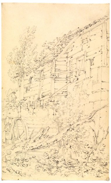
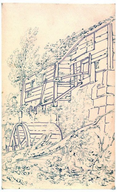
Turner Sketches Housed in the Virginia Museum of Fine Arts, Richmond VA, USA
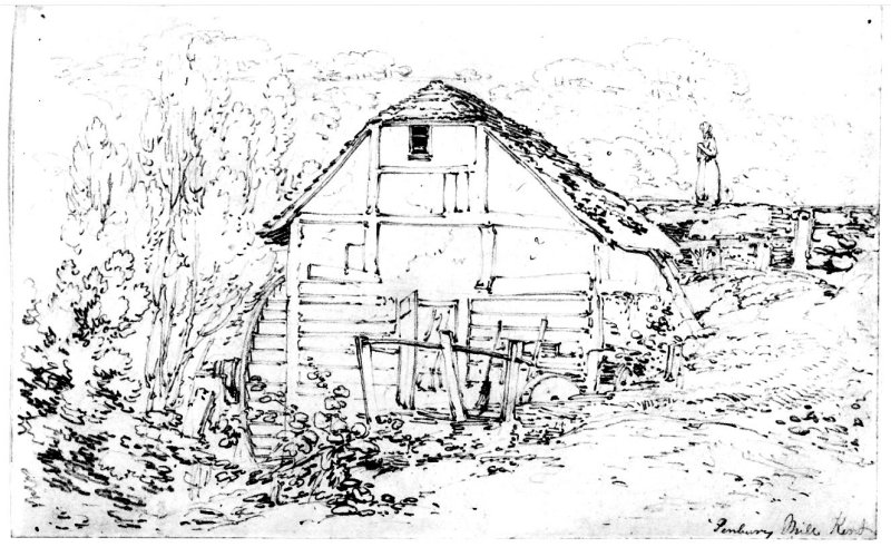
Front View Pembury Mill, Kent p008
p009
|
|
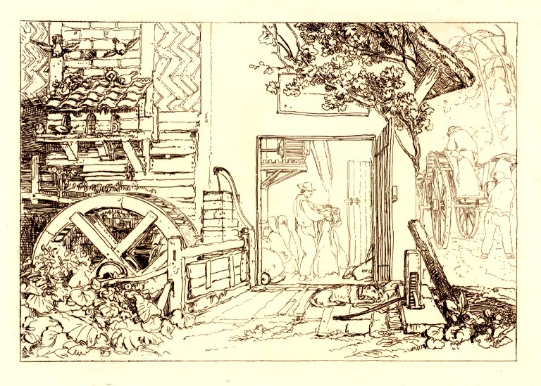
| Side View of Mill
Left: as sketched. Right: enhanced to visually clarify the mechanisms |
Extract from Mary
Standen’s Pembury in the Past
1984 (page 15)
Below a misleading article by Mary Standen
writing about Keyes Mill but showing the etching
of Spring Grove Mill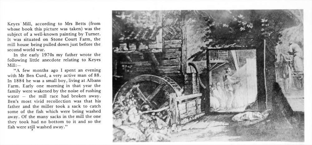
P010
(1) Keyes Mill House demolished just before the second world war (1938 or 1939). Mill House – not Mill. Mill may have long gone.
(2) Mill race broken in 1884. The above illustration is of 'Pembury Mill' or 'Spring Grove Mill', not 'Keyes'.
Jane Grooms 2020 –
THE SEARCH FOR KEYES MILL March to August 2020
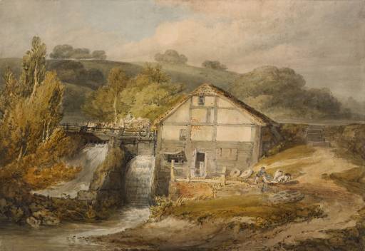
JMW Turner created many pictures of watermills,
three of which are thought to have been based on
watermills in Pembury; Keyes Mill (also known as
Herrings Mill) in Snipe Wood and Spring Grove Mill
in Redwings Lane.
The two watercolours are believed to be of Keyes
Mill. One watercolour entitled ‘Pembury
Mill’ held at the Victoria and Albert Museum,
1795/6, shows a mill with one mill race to the
side of the building. The second watercolour
entitled ‘A Watermill’, 1795/6, held at the
British Museum shows the same building but with
two mill races to the side and other differences.
The third picture, an etching, is called ‘Pembury
Mill, Kent’ published in 1808 and is held at the
Tate.
Springrove mill building still exists but little
remains of the Keyes Mill buildings. Keyes Mill
House is thought to have been demolished just
before the second world war and the Keyes
watermill was probably not in use many years
before then.
I had often thought how interesting it would be to
find the location of Keyes watermill and to
imagine where JMW Turner would have stood to paint
his watercolour of the mill and to see if the
existing landscape could reveal which of the two
watercolours is a more accurate depiction of the
mill. The following is a summary of my research
and findings:
THE MAPS
There is an Ordinance Survey Map of 1813-19 which shows ‘Herrings Mill Wood’.
The Tithe Map signed in 1844 shows ‘Keys Mill’ with one building in red and other buildings in grey. According to the National Archives, red buildings are habited and grey buildings are uninhabited. The Tithe Award Schedule shows :
plot 559 as ‘Waste’
plot 560 as ‘House & Buildings’
plot 561 as ‘Mill & Road’
plot 569 and 569a as ‘Pond & Waste’
plot 570 as Upper Pond
plot 571 as ‘Waste & Roadway’
It follows that the red building on the Tithe Map
is a house in which the miller and his family are
likely to have lived. The mill building painted by
Turner is probably the grey building shown by the
water on the Tithe Map in plot 561.
The Tithe Award Schedule records Stephen Sawyer as
the owner of plots 559 to 572 and 579a. John
Homewood is recorded as the occupier.
The 1841 census of England and Wales shows a John
Homewood living at ‘Keys Mill’ with six children.
His wife is not mentioned. In the 1851 census,
John is recorded as a ‘master miller’ at Brenchley
Windmill.
A Stephen Sawyer married Mary Veness in 1815 in Pembury. The first witness is stated as Benjamin Veness. A Benjamin Veness is mentioned on the Tithe Award schedule as owning various shops in Pembury but it may not be the same person. In the 1841 census, Stephen and Mary Sawyer were living at 1 Cumberland Gardens, Tunbridge Wells along with servants and Abigail Veness (mother in law?). In the 1851 census, Mary Sawyer is recorded as a widow. A Stephen Sawyer died in 1848 and is buried at the Holy Trinity Church, Tunbridge Wells. If this is the same Stephen Sawyer who was the owner of Keyes Mill, perhaps this explains why John Homewood went on to work at Brenchley Windmill after Stephen Sawyer’s death. It is interesting that John Homewood had a son called Stephen who also became a miller and was still living with his father at Brenchley ‘flour mill’ in 1861.
The Ordinance Survey map of 1868 shows Herrings Mill as ‘Disused’. Caution has to be taken in making assumptions that the mill was disused by 1868 because maps were often updated after printing without changing the date of the map. However, some time between 1861 and 1871, the occupier of the mill house at Keyes Mill, Nicholas Styles, no longer had the occupation of ‘miller’ (see my research into the occupiers of Keyes Mill from 1840). The fact that the mill became disused in the 1860’s is also supported by the waterworks that occurred to divert water away from the streams (see newspaper article below). There is a story of a gentleman, Ben Curd who remembered a ‘mill race’ breaking in 1884 when he was a young boy living at Albans Farm (see extract from Mary Standen’s book). The landscape suggests a breach of the dam occurred at some time but it seems unlikely that the mill was in use in 1884. The lower and upper mill ponds of Keyes Mill can be seen clearly on the 1868 map as well as water channels connecting the two. The Lower Mill Pond is the larger of the two and is downstream of the Upper Mill Pond. The Upper Mill Pond appears to have a circular island in the middle with a square on the island possibly a building.
It is interesting that on the 1813-19 Ordinance Survey map, the mill is called Herrings Mill then on the Tithe map it is known as ‘Keys Mill’ then on the 1868 map it is called Herrings Mill again. Perhaps the latter Ordinance Survey map just used the text from earlier Ordinance Survey maps but this needs further investigation.
WHAT REMAINS OF KEYES MILL TODAY?
It is still possible to see remains of Keyes Mill. On footpath WT226, a stone culvert exists (Fig 1 & Fig 2) which carried water from the Upper Mill Pond through the Pond Bay (dam). WT226 runs across the top of the Pond Bay at this location.
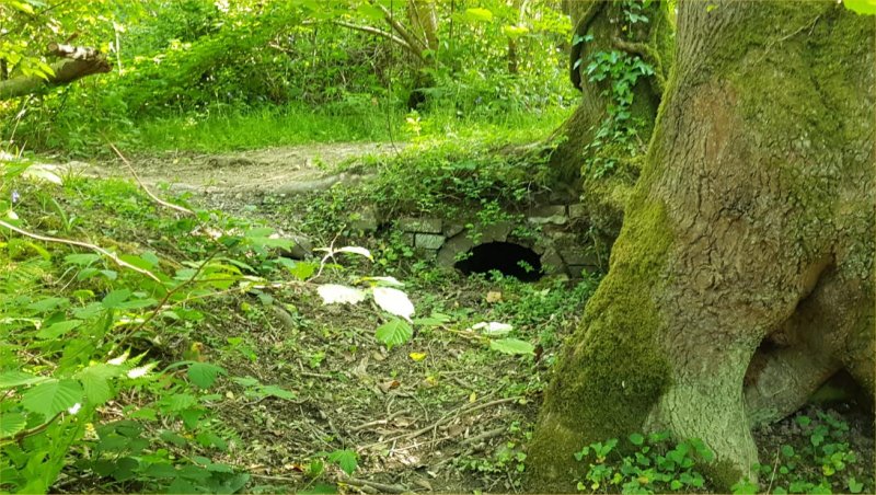
Fig
1
p011
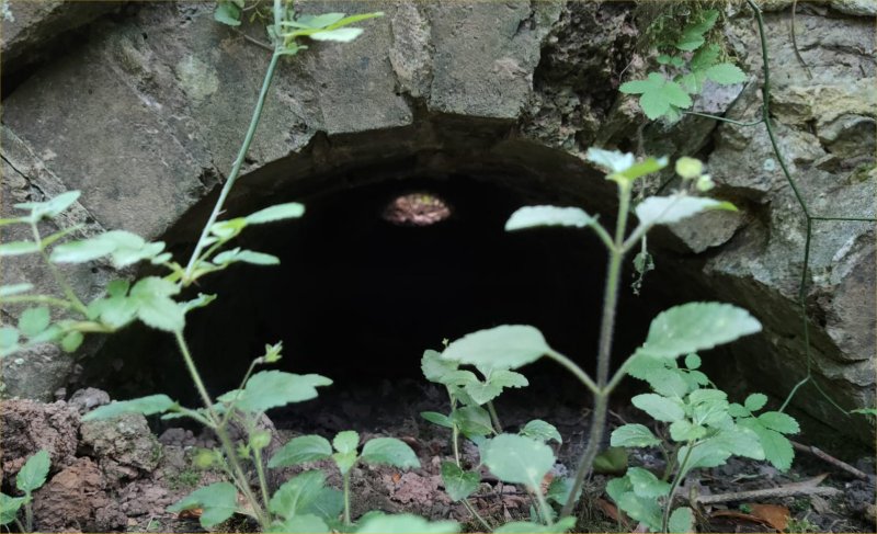
Fig 2
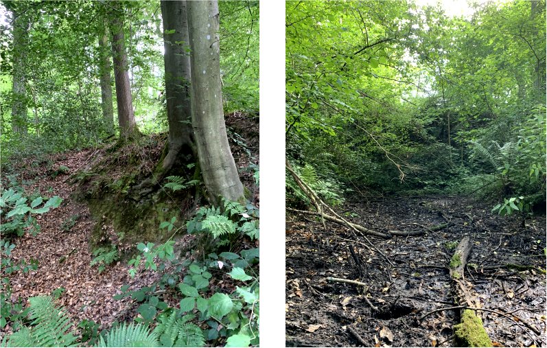
On footpath WT222, near the wooden footbridge, a Pond Bay runs to the North along-side the footpath. To the South of the footpath would have been the Lower Mill Pond. A brick culvert exists (Fig 3) which passes through the Pond Bay and carried excess water from the Lower Mill Pond and downwards past the mill and into a stream. This side water channel is now a boggy area where water collects (Fig 4). The current stream is a breach of the old Pond Bay and so is not in the same location as the water channels shown on the Tithe map but is approximately in the middle.
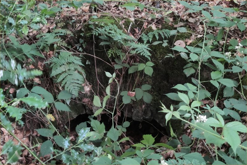
Fig 3
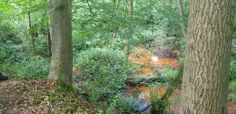
Fig 4
Brickwork (Fig 5) can be seen on the downward side of the Pond Bay near the stone culvert but no building is shown on the maps so further investigation needs to be made as to what this could have been.
Fig
5
Fig 6
To the east of the current stream, on the downward side of the Pond Bay more significant brickwork exists (Fig 7) together with rubble and evidence of the location of a wheel race (Fig 6). I believe this is the location of the Keyes watermill building. The wheel race would have been as high as the Pond Bay and water from the Lower Mill Pond would have flowed over the top of the Pond Bay to power the waterwheel.
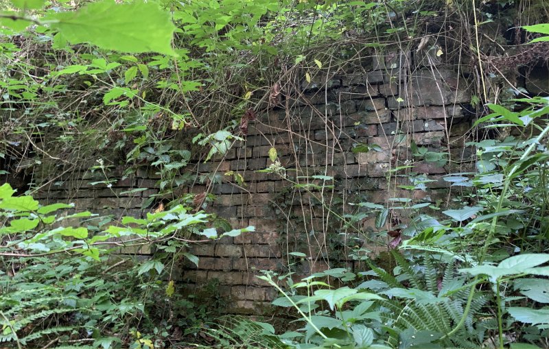
Fig 7
There is a flat area higher above the site of the
watermill building where I believe the red
building on the Tithe map would have been and is
likely to have been the mill house where the
miller and his family lived.
I believe the watercolour at the Victoria and
Albert Museum entitled ‘Pembury Mill’ is the more
accurate depiction of Keyes Mill when considering
the water marked on the maps and the current
landscape. Snipe Wood is privately owned and
a Historical Environment Record exists for the
area. Both stone culverts can be seen from the
public footpaths.
Thank you to David Brown for his invaluable help in understanding the landscape and to Tony Nicholls for providing images of relevant maps and advice on their dating and features.
Jane Grooms
p012
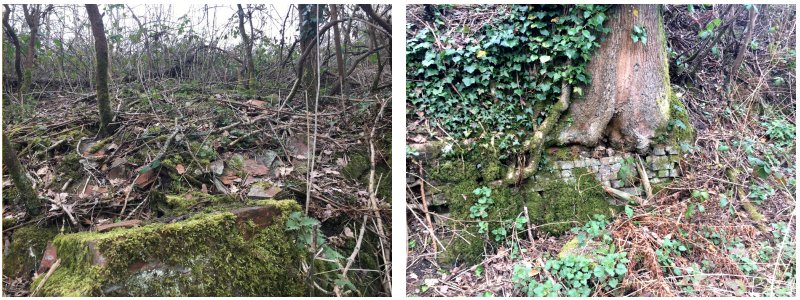
Additional pictures of the mill house remains
taken by Jane Grooms in March 2021.
They show a brick wall and terracotta tiles in the
location of the Mill House.
p013
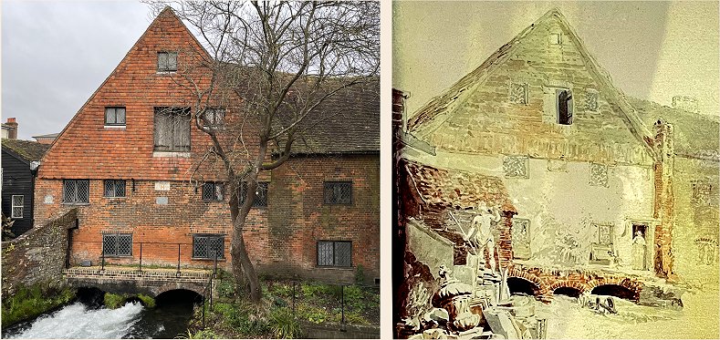
This is NOT Pembury, but a mill in Winchester painted by Turner in 1795
Newspaper Cuttings
related to the Keyes Mill
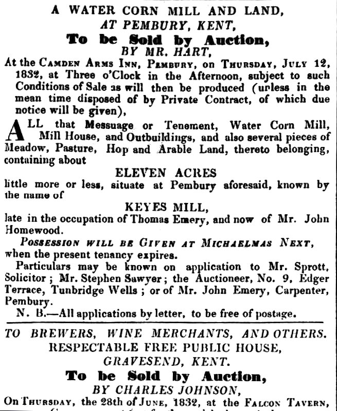
Above – from the Maidstone Gazette and Kentish
Courier 1832 – the auction of Keyes
Mill. Submitted by Jane Grooms
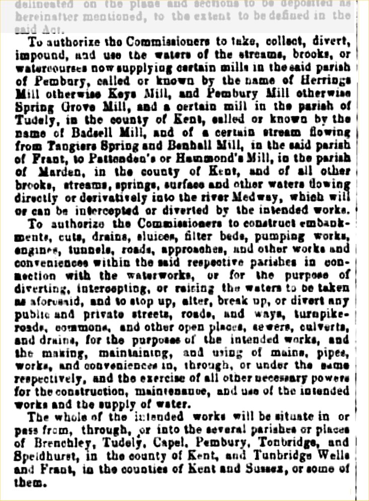
Above – newspaper cutting from 1864 proposing
stream diversion and water extraction for the
reservoir.
Submitted by Jane Grooms and Jennifer Beviere.
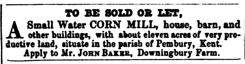
The advertisement above appeared twice in the
South Eastern Gazette on the 5 February 1856
and the 12 February 1856:
Notes by Jane Grooms:
"house, barn and other buildings" in Pembury. The mill is believed to be Keyes Mill/Herrings Mill because:
to Sarah Veness whose sister, Mary Veness was married to Stephen Sawyer.
Stephen Sawyer owned Keyes Mill circa 1840 but Stephen died in 1848.
It is probable that when Stephen Sawyer died, Keyes Mill came under the care of John Baker as a family member.
This is a part of an article from Pembury Village News issue 122 (June 2005) page 23 Full copy available from the PVN archive.
Why did we change the name of the farm?
The access to the farm had been altered in the1980s, separating Herring Mill Farmhouse from Herrings Mill Farm. In 1995 Herrings Mill farm and Three Towns Farm were merged together and the name of the farm for the farming community and postal purposes became Herring Mill Farm. The separation of Herring Mill Farmhouse and Herring Mill Farm had, by the time we bought the farm in2003, started to cause a lot of confusion.Herrings Mill Farm is not actually shown on the Ordnance Survey map but Three Towns Farm is, as is Herring Mill House on Bramble Reed Lane. This didn’t help for people trying to deliver things to the farm! Often the Herring Mill farmhouse would have to redirect delivery men back up Romford road.Some of them would end up half way up their garden before they could be stopped!! So we decided, as we moved in, to change the name of the farm to make it clear going forward that the farm entrance wasn’t next to Herring Mill farmhouse. Once we had decided to do this we had to think of a name.We wanted to follow farming tradition and use a family name – “Bentinck” is a family name and therefore has strong connections for all of us.
--------------
General articles covering Spring Grove
Mill and Keyes Mill
--------------
|
Expert Opinion
In December 2023 we were contacted by Dr Selby
Whittingham, an expert on JMW Turner. He noted that
this web page contained Turner related information
not previously known to him or the V&A Museum.
This 'Gazetteer" document by Dr Whittingham contains a wealth of information on Tonbridge, Pembury and district.
Appendix 8 on page 57 contains information on the Pembury Mills.
Many thanks to Dr Whittingham for sharing this information with us, and allowing us to display his Gazetteer.
Turner's Connection with Pembury
Jane GroomsJoseph Mallord William Turner (JMW Turner), the well known artist, is known to have created watercolours and drawings of water mills in Pembury. He was born in 1775 and died in 1851. He created lots of paintings and drawings of water mills but why did he choose to visit Pembury?
JMW Turner’s mother was Mary Mallord Marshall. Her sister was Sarah Marshall who married the Reverend Henry Harpur (1732-1790). The Reverend Henry Harpur became vicar of the Tonbridge parish church from 1756. It follows that JMW Turner’s aunt and uncle lived in Tonbridge. One of their sons, William Harpur (1767-1819) became an employee/gamekeeper for William Woodgate who owned properties in Pembury including Spring Grove Mill. It is thought that JMW Turner painted/drew Spring Grove Mill and Keyes Mill on visits to the Harpur family.
It is interesting to note that the Reverend Henry Harpur oversaw the first curacy of George Austen, Jane Austen’s father. Also, Henry Harpur (born circa 1791), the Reverend Henry Harpur’s grandson became a close friend and professional adviser to JMW Turner despite their age difference and dealt with the estate of JMW Turner.
Thank you to Dr Selby Whittingham for his assistance in the discovery of JMW Turner’s family connection to Pembury.
Further notes by Dr Whittingham (15 Jan 2024) -
catalogue points out he made separate trips to places near London apart from those and we know he went to Knockholt near Sevenoaks etc. If my assumption is correct, Turner in 1793 would have called/stayed at Little Hawkwell, conveniently placed for sketching Keys Mill.
We found Ashby first mentioned at the mill in 1821, as before that no occupant was given, so he might have been there earlier.
The watercolour for the Spring Grove Mill is a little more free than Turner's etching and the mezzotint. The waggon on the right must be on a path to Redwings Lane, basically unchanged? This should give a clue to the orientation. As should the light. Unfortunately we don't have Turner's pencil drawing on which all would have been based and that would not have given the direction of light. Luke Herrmann presumed the time was late afternoon/evening. The 1783 drawings are scattered for some reason and not in the Turner Bequest at the Tate. They include a drawing of Tablehurst Mill near the source of the Medway towards E Grinstead. Evidently Turner, starting from Tonbridge area worked his way up the river to there making a series of drawings. Maybe he drew Spring Grove Mill at the same time or it could have been later.
The British Museum has no details of the provenance of its version of Pembury Mill except the names of the people who gave it. The V&A version was claimed to have belonged to the same family since 1825.
The mill at Groombridge preserves a lot of the old machinery but not the wheel. Turner's De Garston descendants (from Pembury) know it. I have never been there however.
Re Keys Mill Mary Standen made enquiries about who had the painting of the mill house, but one informant's husband had recently died and she did not like to press the enquiry (c.1990).
The fact that Turner made two watercolours of Keys suggests he had a commission or persons in mind, and I suggest that the most likely ones would be members of the Harpur family, two marrying in 1795 and 1796.
He was referring to Spring Grove Mill and was comparing the first edition OS map (m003) with the second edition and advised the following:
Usually a watermill building would be separate from the miller's house, although close by. So where the later map refers to 'mill cottage' and only one building remains, this suggests the remaining building is the house. Next to this on the earlier map is another building......On the later map, you see a channel of water where this building previously stood. This seems to me to make it likely that this was the mill building......
From the Turner etching, it looks like the [water] ran alongside. The projection on the left of the building on the map could represent the waterwheel as this is sometimes how waterwheels were shown.
Kathryn Franklin 2020 –
Corn mills have always been important in Pembury as even as early as the 13th century the Colpeppers were in dispute over two and millers appear in Pembury records from time to time throughout the centuries. Streams are numerous but the water flow in the past must have been much greater than it is today now that the area is used as a significant catchment area for Southern Water.
In Turner’s time at the turn of the 19th century there were still two mills in the parish, but unlikely to be the same two as 500 years earlier. He painted one once and the other one twice. All three of his paintings have the title ‘Pembury Mill’ which is confusing as you do not have to be an art expert to realise they are of two different buildings.
One, in Redwings Lane, still exists but it is now a private house and much altered. At some time the course of the stream has been moved from the front of the building, where the wheel can be seen in the picture, to the back. The pond-bay still exists. This is the more famous picture, with a lady in the door-way, that sometimes appears in books on Turner. It was painted in 1795 and is held at Tate Britain.
The other two pictures were painted in 1805 and 1807 respectively and, allowing for artistic license, they are clearly of the same building and painted from more or less the same position. One is held at the British Museum and the other at the National Gallery. It’s location is now on footpath WT222 in the woods between Stonecourt and Albans. There is some remaining brickwork if you look carefully and, if ground conditions are right, you can even get to where Turner must have positioned himself. The mill went out of use c1885, but the nearby house continued to be lived in until the early 1920s.
Additional note:
There is sometimes confusion caused
because the Turner Mill (k/a Keys
Mill) was sometimes also known as Herrings
Mill but there was another Herrings Mill not
far away in Matfield. (Mr Herring occupied
land in both Pembury & Brenchley
(Matfield) in the 16th century!)
Notes from “Walk Along and Around the Tunbridge Wells Circular” book (forwarded by Jane Grooms)
The Site of Keyes Mill – “A watermill stood here until 1939, and was painted twice by Turner in 1795 and 1796.”
“The causeway formed a dam between the upper and lower mill ponds.” Do we assume the causeway to be the WT226 footbridge?
See Mary
Standen item higher in this page where she
describes the mill house (not the mill)
demolished just before
WW2.
Misleading history!
Millers in Pembury from Commercial Directories
Pigot’s Directory 1840 – Millers – Richard Ashby (Spring Grove), John Homewood (Keyes) , (Stephen Tolhurst – corn dealer – not miller)
Post Office Directory 1855 – Frederick Ashby miller. (no location)
Melvilles Directory 1858 – Richard Ashby miller & farmer. (no location, assumed Spring Grove from 1840 Pigot’s)
Post Office Directory 1878 – Edwin Coppard, miller Spring Grove Mill
Kelly’s Directory
1882, 1886, 1889, 1889, 1903, …….
– no
millers in any edition. Assume
Pembury is absent of millers & working
mills?
Several of
these later directories list corn merchants
in Pembury. Directories at this
page – References
Chronology Tables for the Occupancy, Ownership and Workings of the Water Mills
Tables prepared by Jane Grooms
Link to Spring Grove Mill Table Link to Keyes Mill Table
Richard Ashby,
Miller at Spring Grove
An additional note that may contribute to the demise of water mills in Pembury. During the 19th century the residents of Pembury extracted more and more water from the land, causing a possible drop in the water table and the flow of water into the streams. Old maps show the increasing annotation of “W” and “P” symbols. These indicate wells and pumps for extracting water. The map below shows a portion of the High Street in the 1890s.
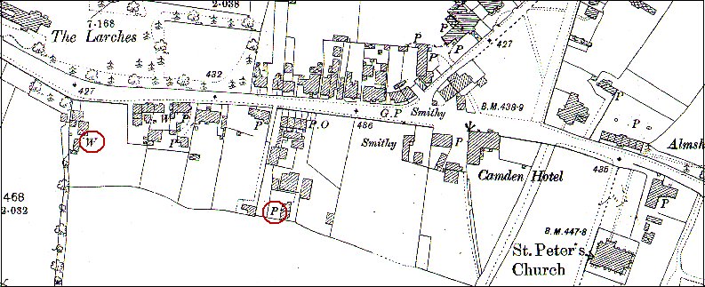
One well and one pump have been circled, but the
maps of Lower Green, Henwood Green, Hastings
Road,. . . all have them.
Notes
on Ordnance Survey (OS) map dating.
National Library of Scotland Mills Research Project
A Windmill in Pembury
In August 2023 we were contacted by Rob Cumming, an author of books on windmills. He came with some evidence of there being a windmill in Lower Green around 1831.This has now been moved to another page - Possible Windmills in Pembury
Tony Nicholls 2020, 2024
|
|
Pembury History
|
|
  |
|
IMPORTANT !!! This needs your help. All contributions will be credited. If you have any further information or corrections please contact me –
Tony Nicholls email: pemburyhistory@gmail.com